Blog Image

PannageMan

About this blog

An occasional blog about commons, village greens and rights of way. New posts will be tweeted at @PannageMan. Any views expressed here entirely my own. Full index to blogs: http://www.craddocks.co.uk/pannageman/index.htm.

Directions for all

Rights of Way Posted on Sat, 22 July 2017 17:25
Jouldings Lane: PannageMan’s sister crossing Jouldings Ford

Sch.14 to the Wildlife and Countryside Act 1981 sets out the procedure for applying for, and the determination of, applications to a surveying authority for a definitive map modification order to amend the definitive map and statement — for example, to add a path not currently recorded, or to delete a path which is said to be wrongly included. An applicant must apply under s.53(5) of the 1981 Act in a form compliant with para.1 of Sch.14, serve notice on the landowners and occupiers affected (para.2(1)), and then certify to the authority that the applicant has served the notices (para.2(3)).

Having done this, para.3(1) of Sch.14 provides that:

‘As soon as reasonably practicable after receiving a certificate under paragraph 2(3), the authority shall—(a) investigate the matters stated in the application; and (b) after consulting with every local authority whose area includes the land to which the application relates, decide whether to make or not to make the order to which the application relates.’

There is no particular time limit imposed on the authority to carry out the investigation and determination, but para.3(2) provides that, if the authority has not determined the application within 12 months of the para.2(3) certificate, the applicant may make representations to the Secretary of State, and the Secretary of State may direct the authority to determine the application within a specified time.

Any applicant making such representations (see the guidance) is informed that:

‘The Secretary of State in considering whether, in response to such a request, to direct an authority to determine an application for an order within a specified period, will take into account any statement made by the authority setting out its priorities for bringing and keeping the definitive map up to date, the reasonableness of such priorities, any actions already taken by the authority or expressed intentions of further action on the application in question, the circumstances of the case and any views expressed by the applicant.’

This is the formula set out in Circular (remember those?) 1/09, para.4.9. For many years, indeed as long as anyone can remember, the Secretary of State would compare the applicant’s case against the circumstances of the particular surveying authority, conclude that the authority was performing satisfactorily against its commitments, and decline to make a direction. This was so, even where, according to the authority’s own assessment, the application was already some years old, and was not due to be considered for many more years.

All this changed several years ago, when, for reasons never explained or announced (but nonetheless welcome from applicants’ point of view), the Secretary of State began to tire of surveying authorities’ excuses, and started to give directions after all. The volte face was all the more startling, because before long, directions were being given even where the delay was quite modest.

PannageMan sought directions in relation to two applications which he made for paths near the Hampshire/Berkshire border, at Jouldings Lane and Riseley Common Lane, in May and December 2013 (Jouldings Lane straddled the boundary with Wokingham Borough Council, but Hampshire had the more substantial interest). Concerned that Hampshire County Council was quoting an eight-year lead time to determination, he wrote to the Secretary of State in June 2016 asking for directions.

The Secretary of State’s decisions finally arrived today, with directions to Hampshire County Council to determine the Riseley Common Lane application within six months, and to both Hampshire County Council and Wokingham Borough Council the Jouldings Lane application within eight months. By present day standards, this is no surprise. But what does surprise PannageMan is the sheer lack of quarter now given surveying authorities.

In his decision letters on behalf of the Secretary of State, the inspector, Michael Lowe, duly recites the relevant words from Circular 1/09, and notes that both applications are ranked well down Hampshire’s list of applications (53rd and 49th respectively out of 68). He then reiterates the expectation that applications will be determined within 12 months (helpfully quoting from the words of the Minister in moving amendments to the then Wildlife and Countryside Bill that suggest that para.3(2) was intended to enable the Secretary of State to administer a swift administrative boot to any authorities that failed to adhere to the target 12 months), notes that PannageMan has been waiting for more than two years already, and finds that the council’s statement of priorities cannot be reasonable under normal circumstances if it does not deliver determinations within 12 months.

So there you have it. The Secretary of State now appears to have moved all the way to a policy under which, if an application has not been determined within 12 months, a direction may be expected to follow, and never mind what the authority has to say. What would happen if the other 66 applicants (or at least, those who have been waiting more than 12 months) in Hampshire also sought directions is anyone’s guess — we can be quite sure that there would be insufficient resources to deliver the casework in the time that the council would be given. But North Somerset Council was directed to determine 20 applications over a period of 21 months, which for a small unitary council suggests an heroic rate of activity.

More’s the pity that, under reforms enacted through the Deregulation Act 2015, the responsibility for delivering that ‘swift boot’ will be transferred to the magistrates’ courts. Instead of making representations to the Secretary of State (online if desired), an aggrieved applicant will need to apply to the magistrates’ court for a hearing, and convince the magistrates that the authority should be directed to determine the outstanding application. Who will want to do that — even before considering the £720 court fee, and the possibility of an award of the authority’s costs against the applicant (think £5,000 upwards)? Meanwhile, landowners, under those same reforms, will get a new right to appeal against the failure of a highway authority to determine an application to divert a public path — an appeal which will lie to the Secretary of State, not the courts.

But for now, applicants who are on a long waiting list for determination are advised to consider the para.3(2) route. And for those who risk being ‘queue-jumped’ because of ‘directions for all’? They should go down that route too.


A diverting story

Rights of Way Posted on Sun, 11 December 2016 15:23

The diversion of public highways, and particularly public paths, is commonplace. Path diversions are generally made by administrative order under s.119 of the Highways Act 1980, or s.257 of the Town and Country Planning Act 1990: the procedure is relatively inexpensive, and usually successful (if success is equated with the order being confirmed). Even before s.42 of the National Parks and Access to the Countryside Act 1949 first conferred such administrative powers on highway authorities, it had always been possible to divert a highway (of any description) by an order of the magistrates’ court (and still is, under s.116 of the Highways Act 1980). So it is that many highways which exist today have been diverted at some point in their history. Sometimes, that diversion may have taken place so long ago that no record exists of the diversion, and no available map is sufficiently old to show its former alignment (but perhaps a slightly sunken track by an old hedgerow may suggest the original way today). More often, in relation to public paths, the highway authority will have diverted the way after the definitive map and statement was drawn up in the 1950s.

But what if a path, recorded on the definitive map as a public footpath, and diverted under s.119 of the 1980 Act, turns out after the event to host ‘higher’ rights than those recorded? What is the effect of the order on those rights which were latent at the time of the order, but unrecognised?

Surprising to report, there seems to be no authority on the question. In Brand & Brand v Philip Lund (Consultants) Ltd, an action which successfully proved (at least between the parties) that Ramscote Lane in the Chilterns was a public carriageway, HH Judge Paul Baker QC notes that:

‘an order was made diverting the track so that it now runs round the edge of the wood. The order was made under the Highways Act 1959 section 111, which is now the Highways Act 1980 section 119. …By adopting the plan in the statement of claim, Lund Consultants appear to accept the efficacy of this order as regards the route of any vehicular way it may be able to establish. I have had no argument on that particular point.’

At that time, s.119 conferred powers to divert only a footpath or a bridleway, and indeed, the order made by the council referred to a bridleway. However, in discussion between the bench and counsel after judgment was handed down, it was realised that, if an order was to be made declaring a vehicular right of way along Ramscote Lane, it was necessary to decide whether the right of way existed along the original way, or the replacement way following the diversion. The judge concludes that:

‘the common-sense of this is that, once there has been a diversion, whatever rights there were over the road are diverted. Just a quick look at the relevant section of the Highways Act would seem to show nothing that precluded that view.’

It seems that counsel for Lund was denied an opportunity to make further representations on that point later at a resumed hearing later in the day, but as his client got his declaration of a vehicular right of way over the replacement way, he might not have been too disappointed about that (although the width of it was tight: 6ft at one point). So the vires of the diversion order was not seriously challenged by any of the parties. Which is a pity. For, so far as I am aware, this is the only reported case even to touch on the question. In due course, following the trial, the ‘bridleway’ became shown on the definitive map as a byway open to all traffic throughout: you can see here where the byway now follows the edge of the wood where it formerly passed through adjacent fields.

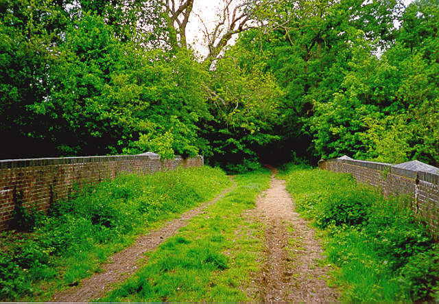
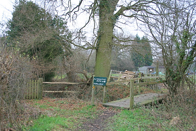
Public footpath along Tenchleys Lane, near Limpsfield Chart, Surrey.

The public footpath formerly followed the course of the Lane through the gate to left and through the garden of Tenchleys Barn. Following a recent diversion, it now follows what, at the time this photograph was taken, was marked as an ‘alternative path’. What if Tenchleys Lane were now proven to be a bridleway? In fact, an attempt to demonstrate just that failed in 2015 (see Pannageman’s report).

For any way with unrecorded higher rights diverted by order so as to expressly address only the recorded rights, there must be at least five conceivable outcomes (in this exploration, I refer to the original way as such, and the diverted way as the replacement way):

  1. The order is effective, and unrecorded rights are lost. The order stops up the original way (of whatever status), and creates the replacement way of the status set out in the order.
  2. The order is effective, and the replacement way is of the status of the unrecorded rights. The order stops up the original way (of whatever status), and creates the replacement way of the same status commensurate with the unrecorded rights formerly embodied in the original way.
  3. The order is effective, but unrecorded rights are preserved. The order stops up the original way only so far as provided in the order, but the higher unrecorded rights are retained along the original way. The order creates the replacement way of the status set out in the order.
  4. The order is effective, but only so as to create the replacement way. The order does not stop up the original way, and creates the replacement way of the status set out in the order.
  5. The order is ineffective. The original way continues to subsist, and the replacement way has no legal status (unless, perhaps, it has been in use for so long that it is deemed to have been dedicated).

None of these options is a particularly attractive one to apply to every possible case, which is why it is hard to formulate principles which can be universally applied. That is not to say that a court should or would adopt principles tailored to the particular circumstances — it ought to be possible to discern some general principles which would apply in every like case. But the approach which a court might apply in a case which comes before it might well be influenced by the circumstances — even though the legal principles, enunciated in that case, but applied in a similar case with different circumstances, might produce unfortunate results.

Let’s illustrate these circumstances with three examples, each of which contemplates the diversion of a footpath subsequently discovered, thanks to historic evidence, to be (or at least, to have been) a bridleway. First, consider a way which is diverted out of a cross-field alignment so that the replacement way runs along the farm drive. In these circumstances, there is no practical reason why the replacement way, a farm drive, should not serve as a bridleway instead of a footpath.

What if the original footpath were diverted to pass through a new housing estate, so that the replacement way were designated with a width of one metre, and were enclosed by two metre high panel fencing on both sides? In these circumstances, the redesignation of the replacement way as a bridleway would be highly unsatisfactory, being of insufficient width to pass two horses. Yet the original way might now be lost under the housing development, and incapable of being resurrected. Practicality (from the landowner’s perspective) desires that the higher, bridleway, rights, should have been extinguished without replacement.

For our third example, imagine a footpath which is diverted out of a farm yard and onto an elaborate detour around the farm buildings, on a narrow alignment with a width of less than one metre, and several stiled crossings of farm access routes. As in the second example, the replacement way is entirely unsuited to use as a bridleway: it is indeed physically impossible to use it as such, and there is no warrant to dismantle the stiles which are lawfully set out as limitations in the diversion order. But, much as the farmer might regret the resurrection of the original way through the farm yard, it is still physically practicable to pass that way, even if it is not particularly welcome to the farmer.

So a court could hardly help but be influenced by the circumstances of a case which comes before it. What of the legal principles which it should apply?

In every case, an order has been made that purports to divert a way which is not as it is described. That constitutes one inevitable defect in the order, which is a failure of description, but there is a second possible defect, which is an absence of powers. If a public path diversion order is made by a local authority under s.119 of the Highways Act 1980, the authority has a power to divert by order any public footpath, bridleway or restricted byway (the last owing to amendment of s.119 by SI 2006/1177, r.2 and the Schedule) in accordance with the requirements of the 1980 Act. What if the original way turns out to have been a carriageway over which rights for mechanically propelled vehicles endure (in effect, what might properly be recorded as a byway open to all traffic)? The authority has no power to divert such a carriageway. The order may have been duly advertised, processed and confirmed, but it remains that the order purports to do what the authority has no power to do. Will a court, advised of the error long after the date of confirmation, leave such an order undisturbed notwithstanding that it was, and remains, blatantly ultra vires? In R (Andrews) v Secretary of State for the Environment, Food and Rural Affairs (generally referred to as Andrews 1), the High Court was eager to rescind an unlawful award of a public path in an inclosure award made nearly two centuries earlier, on the ground that the inclosure commissioners had no power to make the award. That decision was subsequently overturned, over twenty years later, in Andrews 2 (see Pannageman’s final comment on the case), but only on the ground that the commissioners did have the necessary powers: the Court of Appeal left undisturbed the finding of the original court that it was proper to revisit the question of powers after such a long elapse of time. Would an ultra vires public path order be equally vulnerable to rescission? Para.4 of Sch.2 to the 1980 Act (applied by para.5 of Sch.6) provides that, after the expiry of the six week period for statutory challenge, an order may not, ‘be questioned in any legal proceedings whatever’ — but there was a similar ouster clause in Andrews 1. It must be said that the question of the ultra vires exercise of powers by public bodies could, and does, fill a substantial part of a legal text book, Andrews 1 cannot be considered, by a long way, the final word on the subject, and I do not intend to explore the point further here. But it is a vexed question surely because, whatever the circumstances, it is unattractive to apply the same rules in every one of a substantial number of highly diverse cases.

Usually, however, a public path diversion order will not have purported to extinguish rights for mechanically propelled vehicles. Far more likely is that the rights addressed in the order are within the scope of s.119 (i.e. the original footpath is subsequently discovered to be a historic bridleway or restricted byway, or the original bridleway is subsequently discovered to be a historic restricted byway), but the order is defective in adverting to the original way as only a footpath or bridleway (as the case may be). In such a case, the order is defective, in that it purports to extinguish something inferior to the true status of the original way, and to set out a new way which is equally inferior. But this time, there is no doubt that the authority had a power to divert the way according to its proper status, even though it did not properly exercise the powers, nor invite objections on that basis. And while the order is defective, the legislation seems to make the position clear: s.119(1)(b) provides that the council may, by order, ‘extinguish, as from such date as may be specified…, the public right of way over so much of the path or way as appears to the council requisite as aforesaid.’ This provision does not provide for the extinguishment of whatever is specified in the order (be it a footpath, bridleway or restricted byway), but the extinguishment of the ‘public right of way’. A court might find the comprehensive scope of that provision seductive in determining the effect of the order on previously undiscovered higher rights.

But there is no compensating solace in s.119(1)(a). This enables the council, by order, to ‘create, as from such date as may be specified in the order, any such new footpath or bridleway as appears to the council requisite for effecting the diversion’. There is no flex in those words to infer that, despite the authority’s error in specifying the creation of a footpath, the legislation has actually operated to create a bridleway (or a restricted byway, as the case may be). My belief, albeit on fairly meagre provision, and in the absence of a compelling set of practical considerations to direct the court to a different conclusion, is that, provided that the order could lawfully stop up the original way, it will be taken to have done so — and that the replacement way will be precisely as specified in the order, and no more.

Of course, different legal mechanisms may lead to different outcomes. If the way was diverted by order of the magistrates’ court under s.116 of the 1980 Act, the magistrates had undoubted power to divert and stop up any highway, and I would conclude that, even if the original way was described only as a footpath or bridleway, but was subsequently established to be a carriageway for all vehicles, the order will be taken to be effective in the terms described in the order.

But that is to decide only between the first two of the conceivable alternatives set out earlier in this blog. What of the other three? In my view, they are conceivable alternatives — but barely so. Alternative three contemplates the designation of the original way as a class of highway unknown to the common law: a bridleway over which there exist no rights on foot, or a restricted byway over which there exist no rights on foot, and perhaps no rights on horseback or on cycle (depending on the terms of the diversion order). Such highways are not entirely alien: motorways and some roads subject to traffic regulations orders are prohibited to ‘inferior’ classes of traffic — but these highways have been so designated for coherent reasons. I find it impossible to imagine how a bridleway available to horse riders but unavailable to pedestrians could make sense. If, however, one conceives that the original way endures without any restriction on the classes of traffic which may use it, then that is alternative four… .

Alternative four is superficially more attractive from a public interest perspective: the original way is found to endure, as does the replacement way. But it has little support from the legislation, nor from logic. The landowner will suffer a ‘triple whammy’: once the error has been identified, not only is the original way resurrected long after it was purported to be extinguished by order, but it is now found to carry higher rights than previously manifest — and the landowner is also lumbered by the replacement way too (it will be small solace that the replacement way has only the status set out in the order).

Alternative five might be equally acceptable to the public: the order is deemed to be of no effect whatsoever. Given that the order was defective (we assume here it was not wholly ultra vires), that might not seem unreasonable — but flaws in the procedural process do not necessarily void the action taken by a public body. And in terms of practical realities, it is perhaps the outcome least likely to make sense, in that the original way may long since have been developed on the assumption that it has ceased to exist, and the public will have used the replacement way as if they had a right to do so. Indeed, throwing open the replacement way for public use might be taken to amount to common law dedication of a right of way, were it not that in the ordinary course of events, the order expressly creates the right of way. In Powell and Irani v the Secretary of State for Environment, Food and Rural Affairs and Doncaster Borough Council (reported by Pannageman), the court found that a way which had been used by the public long after it had been diverted elsewhere, had come into being through presumed dedication, even though the landowner might have assumed he had no power to interfere with use of the way because it was still shown incorrectly on its original alignment on the definitive map. So alternative five might, in many cases, be indistinguishable from alternative four: both may lead, after a sufficiently long interval, to the establishment of public rights over both the original and replacement ways.

If this analysis turns out to be correct, it has significant implications for research to identify and record, on the definitive map and statement, under-recorded rights of way. For if the candidate right of way was previously diverted with only the status then apparent, it may be that any application to ‘upgrade’ the way cannot succeed, at least in respect of the original way stopped up. Given how widespread is the diversion of public rights of way, this may be a significant impediment to such research.


Restoring the record in East Kent

Rights of Way Posted on Fri, 11 November 2016 11:32

Those who have ventured from the Pannageman blog into the web pages mentioned in About the author opposite may have stumbled upon the ‘Applications‘ suite of pages. This reflects a personal interest in rights of way research, and catalogues a number of applications, and draft applications, to add to the official record various unrecorded public rights of way, and in one case, common land, largely focused on East Kent. I’m sometimes asked what inspired me to embark on research in this area, given that I live in Surrey. So here goes.

I’ve always been fascinated by Britain’s rights of way network, and a keen walker and rider. But rights of way research — researching, documenting and applying for the recording of public paths which escaped the creation of the definitive map of rights of way in the 1950s — is a more recent interest. I first got involved in identifying the historic character of a route in Fetcham, Surrey, which I and others from our livery stables had ridden for years, but had lately attracted criticism from some locals because of its recorded status as footpath. Research in the late 1990s demonstrated that the ‘footpath’ was an old road, part of Kennel Lane, which had been eclipsed by development of housing, and escaped being tarred in the industrious period between the two World Wars when most public roads were visited by the tar painting gang. The county council compromised by obtaining an order from the magistrates’ court to stop up the road subject to bridleway rights, and today, the route is recorded as a public bridleway.

Unsealed former carriage road bridge on Kennel Lane, Fetcham

Fast forward to the present decade, and I embarked on some research on the Hampshire and Berkshire border, near Bramshill, to identify two restricted byways (carriageways over which rights for mechanically propelled vehicles have been extinguished) in an area where my sister lives, and which I have frequented on many walks and a few rides over the years. Two applications for these restricted byways to be recorded on the definitive map were made in 2013: these and subsequent applications can be viewed here.

In 2013, a friend who had been walking in East Kent ventured down the minor road to sequestered Knowlton village to view St Clement’s church, a redundant church under the care of the Churches Conservation Trust. The Ordnance Survey Explorer map at that time (and still, at the time of writing), showed the continuation of Knowlton Lane past the church as a ‘yellow road’ for about 100 metres — usually a good indication of public status, but the visitor was confronted by a sign which read ‘Private: No public right of way’. Knowing that I’d be interested in the contrast between map and reality, he passed on the details.

It didn’t take me long, even from desk-top research, to conclude that there was something missing from the map. A little east from Knowlton, beyond the end of that ‘yellow road’, the Explorer map shows a public footpath, beginning at the parish boundary, east towards Thornton Lane; moreover, the Ordnance Survey marks the way ‘Black Lane’ — as it has ever since the first large scale map was published in 1872. Enquiries to the county council revealed that, when the definitive map was drawn up in the early 1950s, there was confusion about whether the way between St Clement’s church and the parish boundary was a public road, which did not need to be recorded on the definitive map, and the parish of Goodnestone did not claim it. Over the years since then, research has shown that Black Lane is an old road or bridle-road of some significance, frequently referred to in the C18 as the main route between Canterbury and Deal. An application for Black Lane to be recorded on the definitive map was made in 2015, with 39 pieces of evidence (though some of the C18 maps are distinctly unhelpful).

At that time, I concentrated on researching the background to Black Lane (and the background is voluminous: the tally of 39 has now reached beyond 50). But the nature of rights of way research is that one thing leads to another. As one trawls the archives, it is impossible not to notice clear indications that the status of other ways has been under-recorded (typically, roads or bridleways as footpaths), or that such ways have been omitted altogether. As an example, the tithe map of Eastry, across which Black Lane runs, shows Black Lane as a distinct track or road. But it also marked two other ways as ‘bridleway’ — one of which is not recorded on the definitive map at all, and one of which is recorded only as a footpath. Such evidence is not conclusive of the status of a way as a public bridleway: it might be argued that the tithe map was not drafted with the purpose of identifying public paths, or that the bridleway was no more than a private right of way (though private bridleways are a rare thing outside inclosure awards). It does, however, inspire further research in pursuit of corroboration.

Black Lane, Knowlton, between Thornton Lane and the dismantled East Kent Light Railway. Of the 2,930m applied for, this short stretch is the only (barely) accessible part — on foot.

Over several years, I have acquired perhaps 25GB of maps, documents and registers covering the former Eastry rural district council’s area, from visits to the Kent County Archives, the National Archives, the British Library and the Canterbury Cathedral Archives. All four have been hugely helpful, and I am also grateful to the British Horse Society’s Kent area for reimbursing my expenses in gathering the data, and Phil Wadey’s and Sarah Bucks’ Restoring the Record for guidance. The consequence is that it is now possible to form a preliminary view on the historic case for any particular way in that area, on the basis of desk-top research drawing on data already accumulated. These data are never the full story: it is often possible to identify further historic documents specific to a particular parish or manor. An estate plan or parish map may provide key evidence, and this will still require additional visits to the archives. But the key building blocks for an application are in place. I have made four applications for ways in East Kent at the time of writing. Three more are in the pipeline, and others may follow.

I was asked by a friend whether I thought about the landowners whose land these ways cross. All of the ways applied for to date cross agricultural or grazing land: in my view, acquiring land brings with it responsibilities as well as benefits. Land has always been subject to often hidden obligations: both private and public rights of way, other easements, rights to light, rights of common and other profità prendre, even the obligation to maintain the chancel of the church or to maintain a public road. These obligations have been pared away over recent years: some of them must now be registered by the beneficiary against the registered title to the land, while the scope to enforce unregistered easements is now somewhat more restricted than previously. But public rights of way, even those not recorded in the definitive map, are not entirely hidden: a cursory look at historic large scale Ordnance Survey maps (now available on-line) will reveal many apparently public paths which, if sufficient other evidence exists, may be the subject of a future application. Consultants are available who will carry out more detailed research for a fee, in anticipation of a prospective purchase. To date, none of my applications has intruded on ‘private space’: a home or its immediate grounds — but even if one does in future, new powers available to local authorities under the Deregulation Act 2015 will enable authorities to negotiate with landowner to agree a diversion order (known as a modification consent order) as part of the recording process.

Why were these paths not recorded on the definitive map? The Dover Express and East Kent News for 4 August 1950 records a parish meeting in Adisham to discuss the parish survey to inform the new definitive map. The report says that:

‘A large map of the Parish was closely scrutinised, showing 13 footpaths and 12 bridle roads. Each path and bridle road was dealt with individually, and, of 13 paths, it was agreed that 7 were necessary, 2 necessary for part of their length and that 4 no longer had any useful purpose. Of the 12 bridle roads, 7 were considered to be still serving a use [sic] purpose, 2 for part of their length and 3 were considered of no use whatever.’

It remains to be seen whether, in fact, those 3 or 5 bridleways ‘considered of no use’ in 1950 were indeed excluded from the definitive map. What was considered useless in 1950 is not necessarily useless today (and vice versa). But the sentiments of the meeting are not likely to have been unique to Adisham.

Research is now up against a deadline. At the end of 2025, most unrecorded public footpaths and bridleways will be extinguished under Part II of the Countryside and Rights of Way Act 2000 (CROW). Were it not for the CROW cut-off, it might be that many unrecorded paths would have been quietly forgotten. But the cut-off, sought by the landowning and farming bodies as a quid pro quo for the right of access granted by Part I of CROW, gives new impetus to identifying these unrecorded routes. And there are only nine years left.


Andrews 2: the end of the (bridle) road

Rights of Way Posted on Mon, 06 July 2015 20:26

Early last year, I first wrote (Andrews twenty years on: inclosure awarded paths revived?) about Andrews 2, in anticipation of an application to the High Court in relation to a claim to record a public bridleway near Chelworth in Wiltshire. For fuller details of the challenge, please read the earlier blog. But in summary, the application was brought by John Andrews, a member of the Ramblers’, against the Secretary of State for the Environment, Food and Rural Affairs, to test a High Court judgment from 1993, which said that inclosure commissioners had no powers to award public paths under the General Inclosure Act 1801.

The majority of rights of way in the English countryside are recorded on definitive maps held by local (‘surveying’) authorities. But many are not, and these risk being extinguished in 2026 under Part II of the Countryside & Rights of Way Act 2000 (CROW) unless recorded before then. Of the various historical sources which may be employed to demonstrate the existence of a public path, inclosure awards are among the first tier, for an award is an early form of secondary legislation, and generally conclusive of what it contains. And since the purpose of inclosure was to parcel up common land into fields and assign those fields to the former interests in the common, then the extinguishment of highways across the commons and their replacement by more rationally organised routes across the new inclosed fields was integral to the task.

So it is that inclosure awards are fertile sources of evidence about public rights of way. Most of these ways are familiar to the local path user and landowner: they are recorded on the definitive map and apparent on the ground. Having been awarded during the inclosures, they may very well follow logical alignments across the fieldscape, running along what are now green lanes between fields, striking out across fields in straight lines, and heading directly for a termination on a local road on an alignment which pays regard to both agricultural economy and parishioners’ convenience. But some escaped the definitive map: perhaps the way had become little used by the 1950s, the path was thought to be private or even a public road, or it was simply an oversight. These are the ones which, even now, may be claimed for the definitive map, prior to the CROW cut-off in 2026, solely on the basis of the award, providing that there is no evidence of any subsequent diversion or stopping up order which may have extinguished the awarded route.

The 1993 judgment was a serious impediment to those claiming such paths, because it found that paths set out under inclosure awards made under local Acts incorporating the 1801 Act were generally ultra vires: that is, the commissioners, who drew up the awards, had no powers to create such paths. The 1801 Act was incorporated in virtually every inclosure Act obtained between 1801 and 1845 (at which date was enacted the Inclosure Act 1845, which substituted a new process for Government oversight of inclosure), so rights of way researchers reviewing an award of this era would need to seek other documentary or user evidence of an awarded path to support any claim.

Conversely, the 1993 judgment was a boon to landowners, because at a stroke, it swept aside half a century of inclosure awarded public paths, unless evidence could be found which demonstrated, aside from the award, that the path was indeed a public right of way. The 1993 ruling was, however, somewhat arbitrary in its effect, since no such flaw was generally present in earlier inclosure awards (i.e. those made under Acts procured before 1801) or later (those made under the Inclosure Act 1845).

Mr Andrews’ application therefore sought to reverse the effect of the 1993 judgment, and was first heard in the Administrative Court of the High Court, where the judge was bound to have strong regard to the findings of the court in 1993. And indeed, and without causing great surprise to any party, the application was rejected in a comprehensive judgment of 141 paragraphs. You can read about the judgment in my second and third blogs.

It seems that defeat in the High Court was anticipated as quite probable, and an appeal to the Court of Appeal was always on the cards. Mr Andrews’ application was supported by the Ramblers’, and was presented to the court at both first instance and on appeal by George Laurence QC and Edwin Simpson. Moreover, Mr Andrews had concluded an own-costs deal with the Secretary of State, which meant that both parties agreed to bear their own costs ‘all the way’, so that if Mr Andrews finally lost his application, he (and the Ramblers’) would not have to pay the costs of the other party, and vice versa. This arrangement is suggestive that the Secretary of State saw her role very properly as upholding the law established by the 1993 judgment, unless and until the courts, following full argument before them, concluded that it had been wrongly decided.

A two day hearing was held in the Court of Appeal in early June before the Master of the Rolls, Lord Dyson, and Gloster LJ and Sales LJ. Messrs Laurence and Simpson again appeared for Mr Andrews and Jonathan Moffett for the Secretary of State. There were four grounds of appeal:

  • that s.10 of the 1801 Act did on a simple question of construction of its language, confer a power to set out public paths;
  • that the 1801 Act should be construed as having inevitably intended to confer such a power;
  • that the 1801 Act was, in the years after enactment, routinely construed as having conferred such a power (the doctrine of contemporanea expositio);
  • that an award made under the 1801 Act was binding in its effect, and even if ultra vires, could not now be challenged at such a remove.

All these grounds were argued before the High Court, as they were before the Court of Appeal, and are explained in the judgment of the High Court. In the Court of Appeal, Mr Laurence also advanced two further grounds:

  • that if s.10 of the 1801 Act did not enable the award of public paths, then s.8 did, and the requirement in s.8 that any highway awarded under that section should be at least 30 feet wide was ‘directory’ (in other words, it was an instruction which, if not complied with, did not fatally flaw the award);
  • that even if the award was capable of being challenged, the considerable passage of time now rendered it inappropriate to interfere with it (citing Micklethwait v Vincent decided in the Court of Appeal in 1893).

In the event, the court gave a judgment clearly in favour of Mr Andrews on the first two grounds (consolidated as the ‘first issue’ in the judgment), and therefore found it unnecessary to deal with the remaining grounds.

The first ground was about interpretation of s.10 of the 1801 Act, which follows s.8 about public carriage roads. This provides: “That such Commissioner or Commissioners shall, and he or they is and are hereby empowered and required to set out and appoint such private Roads, Bridleways, Footways, Ditches, Drains, Watercourses, Watering Places, Quarries, Bridges, Gates, Stiles, Mounds, Fences, Banks, Bounds, and Land Marks, in, over, upon, and through or by the Sides of the Allotments to be made and set out in pursuance of such Act…”. Does ‘private’ (which I have italicised) qualify just ‘Roads’ (as Mr Laurence contended, so that the commissioner had a power under s.10 to award public Bridleways and Footways) or the whole list including Bridleways and Footways (as Mr Moffett contended, so that the power extended only to private ones)?

In its single judgment given by the whole court, the court notes (para.30) in its analysis of the first ground: “We start by observing that the 1801 Act is not drafted with the degree of accuracy and consistency of language that is found in modern statutes.” This sets the agenda for the judgment: in contrast with the judgment at first instance, and in 1993, the court is signalling that the principles of judicial interpretation applied to a modern statute are not necessarily appropriate to a two centuries old enactment drafted in an entirely different era, when the draughtsman may have had very different motivations and principles. The judgment recognises that the Act was prepared long before the Office of Parliamentary Counsel first started to impose common standards of legislative drafting. And it adopts Mr Laurence’s analysis of s.8, which contains a mishmash of different expressions to refer to the same concept of public carriage roads, even within the same section, suggesting that the draughtsman saw little need to adopt consistent language. As the court says (para.32), “This is not a promising basis on which to mount a linguistic argument as to the meaning of section 10 of the 1801 Act.” The judgment explains (para.33) that it may adopt a ‘purposive interpretation’ to reflect the intention of Parliament where a literal interpretation produces a result which is inconsistent with the statutory purpose or makes no sense or is anomalous or illogical, and concludes that a purposive interpretation is all the more appropriate in a statute which is couched in language which is less consistent and more imprecise than that generally found in modern statutes. However, the court concludes that “it is not necessary to find that a particular interpretation would be perverse or absurd before it can be rejected as one that Parliament cannot have intended. That is to set the bar too high.” It therefore rejects the precept on which the lower court proceeded (that a purposive approach will be applied only if, otherwise, “the interpretation contended for is ‘absurd’ or ‘perverse’).

The court goes on to explain (para.35) that practice adopted in enabling inclosures prior to 1801 “provides strong support for the appellant’s case that section 10 should be interpreted as having conferred the power to set out and appoint new public bridleways and footpaths”, and reviews how the 1801 Act is likely to have been founded in such practice. It observes that the purpose of the Act was primarily to consolidate provisions previously contained in local inclosure Acts, rather than to “to change the law, practice or procedures” (para.36), notes research which showed that most such pre-1801 Acts did confer powers to set out public paths, and concludes (para.38) that, “It seems unlikely that Parliament would not have intended to give commissioners the power which they had previously exercised repeatedly pursuant to local Acts to set out and appoint public bridleways and footpaths.” The court notes the defendant’s argument that the 1801 Act did not include some provisions frequently found in local Acts (though I would note, as an aside, none appears quite as essential to the usual process of inclosure), but is unpersuaded. It concludes (para.41) that Parliament would have intended to confer powers in relation to public paths (“It is most unlikely that it did not intend to do so”) because:

  • the 1801 Act was intended to embrace the key powers usually needed for inclosure;
  • “public bridleways and footpaths were crucially important in the late 18th and early 19th centuries for those who wished to travel on foot or on horseback (the majority of the population)”;
  • the 1801 Act conferred powers to set out public carriage roads and private paths: why not public paths too?

In short, the court says (para.42), “unless the statutory language compels us to interpret section 10 as applying only to private bridleways and footpaths, a purposive interpretation leads to the contrary conclusion.”

The court, having justified the adoption of a purposive approach, then somewhat revisits its arguments to explain three compelling reasons why a purposive interpretation must lead to the conclusion that Parliament intended to confer powers in relation to public paths.

  • “Public bridleways and footpaths would have had a far greater public importance than private ones and potentially the same public importance in practical terms as public carriageways. …There would inevitably be a need in almost all cases for provision to be made in relation to public bridleways and footpaths.” (para.44) In PannageMan’s view, the court strays a little (para.45), when it questions “that it is difficult to identify any strong public interest in a public official like a commissioner setting out private roads and footpaths on private enclosed land at all. It might be asked: why not leave it to the owners of the newly enclosed land to decide whether and where to create private paths and roads?” The purpose of creating such private routes was because the route conferred an easement for one allottee over land allotted to another: if the award failed to set out such easements, then the first allottee risked having no or inadequate access to the allotted land, and no means to compel the second allottee to rectify the position. Be that as it may, the court nevertheless concludes that Parliament cannot sensibly have intended to confer powers to confer private paths, but not public ones.
  • The court also picks up on a bizarre consequence of the original judgment in Andrews and conceded by the defendant in the present case: that if the inclosure commissioner had no power to set out new public paths, then he had no power to extinguish existing paths. The defendant had also accepted that an inclosure commissioner could include existing public paths in the award (in effect, for information), on their original alignment, because there was nothing to say that he could not. As the court observes (para.47), “it would be very odd if the award and map, which were intended to be definitive, in fact could not be treated as definitive in relation to existing public bridleways and footpaths stipulated in the award and shown on the map, because (on Mr Moffett’s argument) those would always be vulnerable to inquiry into the pre-existing facts to determine whether or not a public right of way existed before the inclosure award was made.”
  • And thirdly, the court accepts that redrawing the network of public paths was essential to inclosure (para.48): “There was likely to be a strong need in many cases to redraw the network of footpath and bridleway public rights of way in a locality so that it would be coherent in the new landscape which was being created.” It was accepted that the commissioner had a power to divert existing public paths, but it made no sense to provide for diversion, but not the extinguishment of a path and its replacement by another.

And so the court concludes (para.50) “that section 10 should be interpreted as giving commissioners the power to create new public bridleways and footpaths unless the language of the section cannot bear that meaning.” The judgment reverts to the words of s.10, quoted above. In court, both parties conceded that the natural interpretation of s.10 was that ‘private’ qualifies the whole list, but Mr Laurence sought to show there were grounds to adopt a different construction. He invited the court to compare the clause to one in a Will: if a Will provides for the disposal of male horses to A, and female horses, pigs and cattle to B, it is unlikely that the testator means that B should get only the female pigs and cattle, but not the male ones (for which no specific provision is made): this attracted some laughter in the court, but when Mr Moffett later sought to underpin the natural construction of s.10, there was a chorus of reminders from the justices about Mr Laurence’s ‘Will’. And so it is in the judgment: the court notes the ‘linguistic imperfections’ in the 1801 Act, and observes (para.56) that, “Since section 8 dealt with public roads, that naturally left private roads as a separate item requiring provision in the context of the standard powers to be created by the 1801 Act. When viewed in that light, it is reasonable to think that the draftsman intended to use the word ‘private’ to qualify only roads rather than to qualify all the items in the list.” The court also draws attention to some supporting arguments advanced by Mr Laurence — although none of these were clinchers, and all were adequately answered by Mr Moffett. Perhaps the most convincing is that ‘private’ must qualify all the words in the list in s.10, or just ‘Roads’: the researcher’s evidence suggested that all of these features could be either public or private, and, just as it was unconvincing that Parliament intended to confer powers to set out only private paths, so it was also unlikely that everything else in the list should also be set out as private — and that if a commissioner wished to award a public watering place for example, special powers would need to be sought in the local Act.

Early nineteenth century case law dealing with these matters was found to be unhelpful and provided ‘little assistance’. And so the court decides that Andrews was wrongly decided, as was Andrews 2 at first instance, and judgment is found for the appellant. In due course, the Secretary of State will have to reconsider Mr Andrews’ claim to record the Crudwell bridleway, and decide whether to direct the local surveying authority to make a definitive map modification order. Or perhaps the surveying authority will accept the inevitable, and decide to proceed with Mr Andrews’ claim without further prompting.

The Secretary of State has yet to decide whether to seek leave to appeal: though if she does, the clear, confident reasoning of the court does not suggest that leave will lightly be granted. There is also the theoretical possibility of amending legislation, to restore the position to that decided in Andrews. That would be decidedly tricky, since there is now no logical reason why paths awarded under the 1801 Act should be treated any differently to those awarded under later or earlier legislation. And CROW is likely to extinguish most such unrecorded inclosure paths in 2026.

The decision of the Court of Appeal will be salutary in enabling, and revitalising, claims for the recording of rights of way, awarded in post-1801 inclosures, on the definitive map and statement. The High Court was told that there were “between 500–1,000 other public rights of way across private land might be capable of being established in other parts of England and Wales if the Claimant’s argument succeeds”. Such claims probably now need to be brought before the CROW cut-off in 2026. It is perhaps a pity that the court did not adjudicate on Mr Laurence’s other grounds of appeal, in particular that inclosure awards must be considered settled law so long after the event, for there will continue to be awards, made under other legislation, where the powers of the inclosure commissioners remain contested. But in spite of that, the Ramblers will be pleased with the outcome, as will other user organisations with a similar agenda.

Reported in The Guardian, The Independent, Grough, BBC News, Western Daily Press.

PostScript: PannageMan understands that there will no appeal. The law is as it is stated in Andrews 2.


‘Other routes with public access’

Rights of Way Posted on Sun, 07 June 2015 22:12

Introduction

If one was to compile a list of post-war initiatives to promote public access to the countryside, what might appear? Certainly, any list should include:

  • the definitive map of public rights of way (under Part IV of the National Parks & Access to the Countryside Act 1949);
  • the depiction of definitive public rights of way on Ordnance Survey maps (from 1960, apparently on the initiative of the Ramblers’ Association)
  • the right of access to open country and registered common land (conferred by Part I of the Countryside & Rights of Way Act 2000)
  • the power for local authorities to provide country parks, the signposting of public paths, and the right to ride cycles on public bridleways (under the Countryside Act 1968)

Perhaps too, recognition should be given to the efforts of access organisations, and particularly the Ramblers’, to secure better recognition by local authorities of their responsibilities to maintain and promote their public rights of way networks.

But there is one more candidate for inclusion: ORPA. No, not the killer whale, but ‘Other Routes with Public Access’, a symbol used by the Ordnance Survey (OS) on its leisure mapping since about the turn of the present century to represent selected public highways which are not public rights of way on the definitive map and statement. The idea for ORPA seems, again, to have originated with the Ramblers’ Association. (Ironically, ORPA is also an initialism of the Off Road Promoters Association, which has a particular interest in these routes.)

ORPA symbols

Here are the ORPA symbols used on the OS’ 1:50,000 and 1:25:000 maps:

What are ORPA? The OS uses the following text in its key: “The exact nature of the rights on these routes and the restrictions may be checked with the local highway authority”. Which is mystifying and unhelpful but consistent with the OS’ practice of minimising its responsibility for the existence of a right of way along any route shown on its maps.

The list of streets

The provenance of ORPA is the list of publicly maintainable streets held by every local highway authority under s.36(6) of the Highways Act 1980: this sparsely worded provision simply requires that, “The council of every county, metropolitan district and London borough and the Common Council shall cause to be made, and shall keep corrected up to date, a list of the streets within their area which are highways maintainable at the public expense.” Subs.(7) goes on to provide that the authority must keep the list available for public inspection at its own office, and the relevant part at the office of any district council (if there is one). And ‘street’ is given the meaning assigned to it in s.48(1) of the New Roads and Street Works Act 1991, which is to say: “any highway, road, lane, footway, alley or passage, any square or court, and any land laid out as a way whether it is for the time being formed as a way or not.” Although this definition has a rather Dickensian feel to it in its reference to ‘passage’, ‘square’ or ‘court’ (similar language can be found in the definition of a ‘street’ in s.3 of the Town Police Clauses Act 1847), there seems to be little doubt that the list of streets must identify any public way, whether in the countryside or in town, which the highway authority is obliged to maintain. And this includes not only the main roads in the authority’s area (but not trunk roads nor motorways: these are maintained by Highways England), but also most residential roads, country lanes, byways open to all traffic, restricted byways, public bridleways and footpaths, just so long as they are publicly maintainable. Whether any particular way is in fact publicly maintainable will be a matter of provenance and history: for example, any public road in existence before the Highway Act 1835 is publicly maintainable, and most public rights of way are — but there are exceptions, including footpaths added to the definitive map of rights of way since 1949 on the basis of long use.

It follows that the list of streets should have a vital role in the highway authority’s functions: it tells the authority, and the public, which highways the authority must maintain, and by implication, those ways (some of which will nevertheless be public highways) which it does not maintain. In practice, the role of the list of streets has been eclipsed for two reasons: first, because highway authorities focus on maintaining the ‘street works register’ required under s.53 of the New Roads and Street Works Act 1991, which must show every street for which the highway authority is the ‘street authority’ (r.4(5) of the Street Works (Registers, Notices, Directions and Designations) (England) Regulations 2007), and the highway authority is the street authority for every publicly maintainable highway, s.49(1)(a). And secondly, because few highway authorities include all publicly maintainable rights of way in their list, even though it seems they should.

How ORPA were identified

Nevertheless, it is the list of streets which provides the provenance of ORPA. The OS has explained to me (in a letter of 2008) that “ORPA were collected [from highway authorities] as a one off exercise approximately ten years ago. Field surveyors visited the local authority highways department and selected from the local authority list of streets with the objective of linking gaps in the existing rights of way network. The list is not comprehensive, for example ORPAs are not shown in urban areas. Currently there is no mechanism in place to update them.” The implication is that it was the OS which selected, from routes shown in the list of streets, those ways which were appropriate to be depicted as ORPA. Remember that most entries in the list relate to the conventional tarred roads in the authority’s area: so the OS was not interested in showing as ORPA roads which were already coloured on its 1:25,000 and 1:50,000 maps, nor in marking ORPA along residential roads which might be assumed to be part of the ordinary highway network. What the OS was targeting was those highways, mainly in rural areas, which were included in the list of streets, but which if they appeared on the OS map at all, did so as ‘white roads’, and where the map user might at best be uncertain about whether there were any public right of way, and at worst, might well assume that there were none, or have no reason to suppose that any existed at all. Uncertainty about public rights was compounded by the untarred character of many of these highways, so that they might be green lanes, or cross field tracks, but with little or no evidence of their legal status. In practice, the public status of some of these ways was transparent: perhaps they were included as part of a National Trail, or they were the only means of access to the start of one or more public paths (although it is not inevitable that a public path begins on another public way). Alternatively, tell-tales of public status might have been discernable to the experienced user: perhaps traces of a tarred surface put down in the 1920s and not maintained since the Second World War, or a highway authority ‘Unsuitable for Motor Vehicles’ sign, which, in the perverse language of bureaucracy, can be roughly translated as ‘Public road which we must maintain for motor vehicles, but don’t’:

Unsuitable for motors: The Drift, off Denton Lane, Harston, Leics © Alan Murray-Rust and licensed for reuse under this Creative Commons Licence

The consensus seems to be that it was the OS which decided what to depict as ORPA, and what to exclude, given access to the entire list of streets. It may be that in some highway authority’s areas, a more prescriptive approach was taken, where the highway authority provided ‘advice’ on what it wanted to be shown, and what it wanted excluded. In many areas, it remains unclear why some ‘white roads’ have been marked as ORPA, and others (known to be included in the list of streets) have not. For example, in Surrey, which has relatively few unsealed public roads, many were either overlooked or excluded from the original survey, but have now been recognised for inclusion in the next edition of the relevant OS maps. In deciding what to show, the OS appears to have adopted some basic rules:

  • ‘coloured’ roads are never shown as ORPA (colouring in practice means the road is either a public road, or in the odd few exceptions, open to the public, though possibly tolled: see the OS statement here)
  • selectivity is exercised even over what is otherwise eligible (e.g. whether to depict ORPA along an isolated residential road)
  • ORPA is not shown where the route is on the definitive map and is therefore shown as a public right of way (even if ORPA implies there may be higher rights)

This last point means that some ORPA are shown as discontinuous, alternating with say a public footpath where the definitive map public right of way lies alternately inside and outside the boundaries of the green lane.

What rights are implied by ORPA?

This bring us to the question of what exactly can be inferred from a route being marked as ORPA? The inclusion of a way in the list of streets technically confirms only that the highway authority accepts that it has a duty to maintain the way (and even then, mistakes are sometimes made, so that ways are wrongly included in the list, and significant numbers of ancient ways may be omitted from the list — not to mention all those rights of way wrongly excluded in most local authority areas). Inclusion does not of itself confirm the status of a way, although it is a safe assumption that if a way is publicly maintainable, it must be at least a public footpath. In practice, most county highway authority’s lists of streets comprise three classes of publicly maintainable ways:

  • main roads which have long been the maintenance responsibility of the county council
  • local roads, responsibility for maintenance of which was formally transferred to county councils under s.30 of the Local Government Act 1929 (as noted in my blog on Bradley Lane or Bradley Path?)
  • urban paths and alleyways, which are typically tarred, and have traditionally been maintained as part of the urban street network

This is a broad simplification: practice varied across county councils, and in urban boroughs, what is contained in the list may be a complete inventory of known public rights of way. Indeed, some boroughs were wholly excluded from the requirement to draw up definitive maps of public rights of way until s.55(3) of the Wildlife and Countryside Act 1981 was brought into force, and even now, lack comprehensive definitive maps for their areas. Bradford is the most egregious example, but in compensation, its list of streets contains details of most of the public rights of way within the former city borough, and the OS has brought that information to life by showing the extensive network as ORPA (see for example this photo of a bridge over a beck near Thornton, Bradford, which is marked on the OS map as ORPA, but which is apparently no more than a footpath). In a typical rural county area, there is a pretty strong likelihood that any way depicted as ORPA and therefore shown in the list of streets is an old vehicular highway — but likelihood is not proof, and from time to time, definitive map modification orders are made for such ways which achieve no more than bridleway status (Bradley Lane is one such example).

Updating ORPA

The OS considers the collection of list of streets data to have been a one-off exercise, and has no plans to review or update the data. In the author’s experience, the OS will make changes only on instructions from the highway authority, and is reluctant to act on any third party intervention, although user groups have secured increased coverage in some areas (such as Norfolk). I infer the OS position currently to be that:

  • new routes must be validated by the highway authority (the OS says it no longer holds the original survey data, so it is unable to validate nominations against those data), including confirmation that the authority considers the route suitable for depiction, so that the OS has assigned editorial discretion to the authority
  • the OS will consider adding only routes which are in the list of streets

This means that, where the highway authority is not pro-actively taking an interest in the ORPA data, and engaging with the OS (and given that in most authorities, unsurfaced roads are still managed by the highways team rather than the rights of way team, there’s precious little resource or zeal for these routes), the ORPA data are sterilised, with perhaps the odd route dropping off the map when somebody complains to the authority, and the authority takes the line of least resistance by calling for it to be quietly removed from the OS map (such action of course technically having no impact on public rights).

The OS will not consider adding privately maintainable public highways as ORPA, nor public highways not maintained by anyone, even though these fit the description of ‘other routes with public access’. In a 2010 report to a committee of Devon County Council concerning a network of lanes south of Honiton which had been subject to a ‘cessor’ order (i.e. the court had ordered that the lanes should cease to be publicly maintainable), it states that the matter was concluded with the “Town Council resolving to ask the County Council to request the Ordnance Survey to depict this section as available for public use. Ordnance Survey was contacted accordingly, and the route appears marked accordingly on its most recent mapping” (see streetmap). However, whatever the past policy, it appears that the OS will not now do this — though why not is unclear.

The future for ORPA and the CROW Act 2000

Many unsurfaced roads in the countryside have been affected by Part 6 of the Natural Environment and Rural Communities Act 2006 (NERC2006), which extinguishes rights for mechanically propelled vehicles over certain public carriageways. Generally speaking, NERC2006 will not have extinguished rights over list of streets routes, because s.67(2)(b) specifically exempts from extinguishment ways which were included in the list at the date of commencement. (Ways which were both included in the list and shown on the definitive map are not automatically exempted, but these will not be shown on the OS map as ORPA.)

There is also the question of whether these ORPA are threatened by the extinguishment of rights of way in 2026 (or later if delayed by regulations) under Part II of the Countryside and Rights of Way Act 2000 (CROW2000). The short answer is generally no: first, because carriageways are not affected by Part II, and secondly because there is an expectation, endorsed by the stakeholder working group on rights of way, that routes on the list of streets (and therefore underpinning almost all ORPA) in 2026 will be preserved from extinguishment even if they are not carriageways, on the grounds that they are duly recorded, even if not on the definitive map and statement.

The longer, more careful answer, is probably not in most cases. Some hesitancy is called for because in some circumstances, ways now shown as ORPA will (on currently understood criteria) be eligible for extinguishment because:

  • a way shown as ORPA on the OS map is erased from the list of streets by 2026 (whether by due process or otherwise), and also is not a carriageway
  • a way shown as ORPA on the OS map was not sourced from the list of streets, and is privately maintainable, or not maintainable at all (see the Devon example above), and also is not a carriageway
  • there may be no comprehensive exemption of list of streets routes in regulations and the way shown as ORPA on the OS map is also not a carriageway
  • amending legislation is passed to extend the CROW2000 provision to unrecorded carriageways, and any of the above applies irrespective of whether the way is a carriageway

Some of these outcomes could occur de facto on the basis of a particular way shown as ORPA on the OS map being assumed to be a public footpath or bridleway, and not a carriageway, and it being asserted that public rights have been extinguished. Since there is no automatic administrative or judicial process to confirm whether a right of way has been extinguished under Part II of CROW2000, this may be a significant practical difficulty. Indeed, under s.54A of the Wildlife & Countryside Act 1981 (inserted by para.4 of Sch.5 to CROW2000), no carriageway may be added after 2026 to the definitive map and statement (or any later date substituted by regulations) as a byway open to all traffic, so even if a way is considered to be a carriageway, there will be no accessible mechanism available to users to demonstrate that the way is a carriageway, still less any means to preserve a public record of that status for perpetuity in a definitive map and statement.

Conclusion The inclusion of ORPA on OS leisure mapping has promoted substantially improved access to the countryside in areas where untarred roads are a significant part of access opportunities — and it has demonstrated how widespread such access can be, and how poorly was publicised information about this access previously. It must be said that the OS’ diffidence about the rights available over ORPA leaves some map users bemused about precisely what rights exist — but then that largely reflects the uncertainty inherent in the data. Just by way of illustration, consider how widespread are the ORPA in this area of Stokeinteignhead in South Devon. Pre-ORPA, any visitor to the area would have struggled to determine whether this extensive network of charming but unsignposted untarred lanes were public or private. Now, the OS map confirms that these delightful lanes, such as this one, can be enjoyed by all:

Unsealed public road to Lower Rocombe near Stokeinteignhead, Devon (photo by the author)


« PreviousNext »