Blog Image

PannageMan

About this blog

An occasional blog about commons, village greens and rights of way. New posts will be tweeted at @PannageMan. Any views expressed here entirely my own. Full index to blogs: http://www.craddocks.co.uk/pannageman/index.htm.

Statutory exceptions to CROW path extinguishment

Rights of Way Posted on Wed, 17 January 2024 16:24
Wide-arched railway bridge under railway line, with grassy track leading to arch, and cultivated fields beyond
Railway bridge near Martin, Kent accommodating potential unrecorded highway: is this a tunnel which could avoid the way being extinguished in 2031?

A. Introduction

A.1. ‘Path extinguishment day’ is set for 1 January 2031. That’s the date on which the provisions to extinguish unrecorded historical (i.e. pre-1949) rights of way take effect. The provisions are contained in Part II of the Countryside and Rights of Way Act 2000 (hereafter, the 2000 Act).  Section 56(1) provides (following amendment by r.2 of the Countryside and Rights of Way Act 2000 (Substitution of Cut-off Date Relating to Rights of Way) (England) Regulations 2023 (SI 2023/1126)) for that date to be set back to 2031 from New Year 2026.

A.2. Section 53 of the 2000 Act defines what, in general terms, is extinguished. The key effect (in subs.(1)) is to extinguish a highway which was a footpath or bridleway before 1 January 1949, which continues to be a footpath or bridleway in 2031, and which is unrecorded. Unrecorded means that the highway is not recorded in a definitive map and statement.

A.3. It’s worth pausing here to note what is omitted from the legislation but frequently not understood: in general terms, historical public roads are not extinguished, whether recorded or not. If a way was a public cart road in 1949, then it endures the 2031 extinguishment, even if not shown on the definitive map and statement. That perhaps primarily is because, were it otherwise, a majority of public roads would be at risk of extinguishment. But it also promotes the curious likelihood that landowners, faced with claims after 2031 to record historical rights of way on the definitive map and statement, will seek to produce evidence (perhaps from hitherto undisclosed archives) that what is claimed as a public road was actually (in pre-1949 history) a footpath or bridleway by reputation, and therefore extinguished in 2031 under s.53. Of course, their incentive is to flourish those records only after 2031, when the evidence they contain is no longer of any use to those claiming footpaths or bridleways.

A.4. However, subs.(3) articulates a further extinguishing provision. Briefly, a highway which is recorded in the definitive map and statement as of a particular status will have any unrecorded pre-1949 higher rights extinguished — but leaving the recorded status intact. Thus (see subs.(4)):

  • any rights to ride (a horse or cycle), drive animals, or to drive a vehicle, over a footpath;
  • any rights to drive vehicles over a bridleway;
  • any rights to drive mechanically-propelled vehicles over a restricted byway.

A.5. For example, if an old green lane, set out in a nineteenth century inclosure award as a public carriage road, is recorded in the definitive map and statement as a footpath, then all rights to ride or drive along it will be extinguished in 2031 — notwithstanding that it is a historical public road and would not be extinguished if it were not shown in the definitive map and statement at all. It seems it is better for a road not to have been recorded at all, than for it to have been recorded erroneously.

A.6. There is a power, in s.54(1)(d) and (5)(c) and s.56(2)(b), for the Secretary of State to prescribe, in regulations, exceptions to extinguishment. It is widely expected that regulations will be made, in the next few years (and in any event before end 2030), to address exceptions in two key categories:

  • highways which are entered in a list of publicly-maintainable streets held under s.36(6) of the Highways Act 1980 (hereafter, the 1980 Act);
  • highways which are the subject of undetermined pre-2031 applications to make a definitive map modification order, or such orders which themselves remain undetermined by 2031.

A.7. Both these exceptions were the subject of an assurance informally issued by Defra in October 2023. It is surprising that these exceptions were not specified in the 2000 Act, although there is a strong hint in s.56(2)(b) that regulations should be made in relation to the latter.

A.8. Defra also at that time said that highways in urban areas would be excepted in regulations, but the details of how an urban highway would be identified, and what provision would be made for trans-boundary highways (part in and part out) were not only not clarified, but are not currently the subject of any consensus.

A.9. Defra added that the Secretary of State had decided not to prescribe an exception for pre-1949 highways in continuing regular use. Such an exception was recommended by the Stakeholder Working Group on rights of way (albeit the definition of such ways had not been addressed), and widely expected and relied upon by stakeholders generally. As the decision is likely to have a very substantial practical effect in extinguishing footpaths, and bridleways, which, although not recorded, remain in regular use to this day, a reversal of the decision between now and 2031 cannot be ruled out.

A.10. Defra further said that it had not come to any conclusion on whether any unrecorded width of a highway otherwise recorded in the definitive statement should be extinguished. You can see further discussion of this issue in my blog, Extinguishing effect on widths of paths under Part II of the Countryside and Rights of Way Act 2000.

A.11. Notwithstanding that the 2000 Act does not directly set out exceptions in what appear to be the most high-profile cases, s.54 nevertheless does include a number of express exceptions. Some of them are quite surprising in their unexpected and potentially radical effect.

A.12. Unfortunately, s.54 is a remarkably impenetrable piece of drafting. What does it do? I have sought to explain the exceptions below. I address them, broadly speaking, in the order in which they appear in s.54, not in terms of their importance.

A.13. Bear in mind that these exceptions are relevant only if the excepted highway is not recorded on the definitive map and statement on path extinguishment day. And bear in mind too that the extinguishing effect of s.53 applies only to ways which are pre-1949 in origin. None of these exceptions is of any use if there is insufficient evidence that the way is indeed a highway: it is not enough to show that a way is excepted from extinguishment — one also must prove, on the balance of probabilities, that it is a highway.

A.14. Examples are illustrated by ways already recorded on the definitive map and statement because they are easy to identify: clearly, such ways are not generally at risk and therefore will not in practice benefit from the exception, save in relation to the extinguishment of unrecorded higher rights.

A.15. What follows is my personal opinion. I am not a lawyer: if you need legal advice, you should seek it. But if you see something which you think is wrong, please comment, and I will take another look.

B. Inner London

B.1. It is a highway in the former administrative county of London, including any continuation of the same path outside that area.

B.2. The former administrative county of London is what is now known as inner London, and prior to the reform of London government in 1965, was the area of the county of London (save that North Woolwich, formerly within the county of London, is not within inner London). In short, path extinguishment day does not operate in inner London and North Woolwich.

B.3. This applies too to any right of way over a highway in inner London. So, for example, restricted byway rights over a way recorded as a footpath on the definitive map and statement for an inner London borough are excepted from extinguishment.

Footpath on slightly raised bank with woodland to right and left, and mature standards along left hand bank. Winter.
Green Lane, Chessington: currently recorded as only a footpath. This is ‘outer’ Greater London, and any higher rights are at risk of extinguishment in 2031

See subs.1(b) and 5(b).

C. Wet-weather paths

C.1. It is a footpath or bridleway which runs alongside a road, not being part of that road.

C.2. This isn’t about pavements (which usually are part of the same highway). Chiefly, it’s about ‘wet-weather paths’, which form on the other side of the hedge, wall or fence bounding a road, and traditionally were established to enable pedestrians (invariably — seldom horse riders) to escape the mud, dirt and traffic in the road, and walk alongside the road in the field. Many of these wet weather paths are recorded on the definitive map and statement, but many more are not and often can be identified on older Ordnance Survey County Series maps. Indeed, it’s not unusual to find both the green lane and the wet-weather path adjacent are unrecorded, or that only the green lane is recorded but as a footpath, or even that the green lane is unrecorded and only the wet-weather path is recorded.

C.3. Similar adjacent paths can be found in other circumstances: for example, where a ‘pavement’ has been created inside an adjoining field (but this usually will be post-1949 in origin); where the road follows a watercourse, or regularly is flooded; or where the road passes through a ford and an alternative but nearly-adjacent route is provided for pedestrians.

Sherbourne, or Albury Street, Surrey: this field-side pavement alongside the carriageway would be protected from extinguishment, even though not recorded on the definitive map and statement

C.4. Some roads have pavements or footways which become separated from the carriageway, either by being raised up on causeways or above any cutting through which the carriageway passes, or by briefly becoming separated from the carriageway (perhaps taking a shorter route around a bend). If these ways are part of the same highway, they will be unaffected anyway; if they technically are separate from the carriageway, they should be preserved by the exception.

C.5. It is not only the footpath or bridleway which runs alongside a road which is excepted, but a continuation of the same footpath or bridleway to connect with another highway (which is not itself extinguished). For example, a footpath which leaves and then initially runs alongside a road, cuts off a double bend in the road, and rejoins the road further on, will be excepted. So will a footpath which leaves and then initially runs alongside a road, before heading off to join another road, or another footpath. All that is required for the exception to apply is that there is some part of the footpath or bridleway at the side of a road.

C.6. What sometimes can happen is that a footpath leaves and then initially runs alongside a road, then has a connection back to the road at the point where it strikes out across the fields to another highway (for the use of those who wanted to pick up the footpath from further down the road). It seems that the continuation of the same footpath beyond the connection back to the road is not excepted. That is because subs.(3)(a) excepts only a footpath which extends from the excepted part (i.e. adjacent to the road) ‘to, but not beyond, a retained highway’. Because the excepted part itself connects with a retained highway at both ends, i.e. at the start, and at the connection back to the road, nothing beyond it is excepted. In practice, it may well be difficult to determine from historical records whether there was such a connection back to the road.

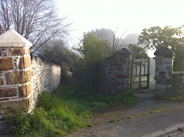
C.7. It is not unusual to find a green lane, which itself is an unrecorded public road, which also benefits from an adjacent, unrecorded, wet weather path. Neither the green lane nor the wet weather path will be extinguished: the green lane because it is a public carriageway, and the wet weather path because it is at the side of a road.

Footpath through edge of woodland with steep drop just visible to left
Footpath next to Ride Lane: the byway can just be seen in the holloway on the left
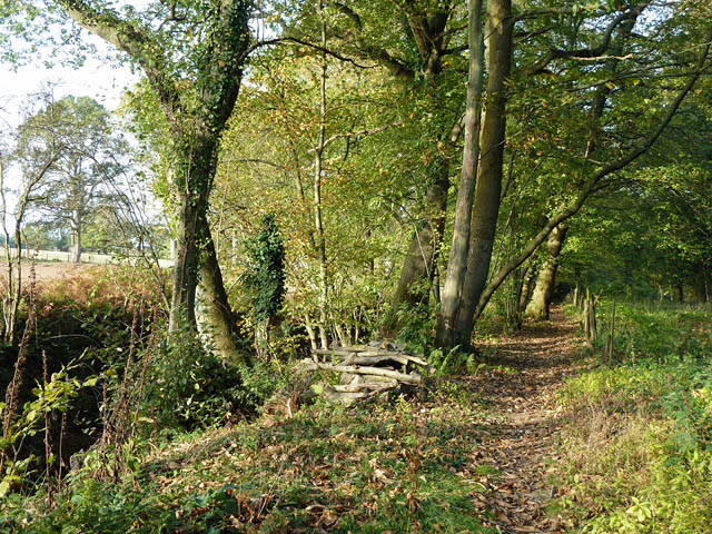
Photo © Robin Webster (cc-by-sa/2.0)

C.8. This example at Ride Lane, Farley Green, Surrey, shows a wet weather path on the east side of an old holloway.

C.9. Would this bridleway at Beech Lane, Effingham, Surrey, be excepted although it is displaced from the carriageway by up to 20 metres? As at least part of it is truly at the side of the carriageway, it appears the answer is yes.

See subs.(1)(c)(i), (3)(a)(ii), (3)(b) and (4).

D. Inter-carriageway paths

D.1. It is a footpath or bridleway which runs between two separate strands of the same carriageway.

D.2. Some dual carriageways divide into two separate strands separated by more than a central reservation: this can happen where road improvements were carried out in the twentieth century so that one carriageway (in one direction) retained the original alignment, and a new carriageway (in the opposing direction) took an improved and separate alignment. A footpath or bridleway connecting the two is excepted.

D.3. It is not only the footpath or bridleway which runs between the two strands of the same carriageway which is excepted, but a continuation of the same footpath or bridleway to connect with another highway (which is not itself extinguished). For example, a footpath which starts from the original strand of the carriageway, crosses to the more-recently constructed strand, and then continues to join another footpath, will be excepted.

D.4. This example on the Worthing Road near Southwater, West Sussex would be excepted, along with the continuation west to Hartsgravel Bridge. The easterly strand of the road is the original turnpike line, the westerly strand later constructed for northbound traffic.

D.5. If there were a continuation east to the nearby Bar Lane, this too would be excepted. And indeed, older maps do show such a continuation, which is unrecorded. It is not clear whether such a continuation will in this case be excepted because the footpath between the two strands of the same carriageway is already recorded on the definitive map and statement. In my view, the more likely answer is not, because s.53 does not apply to the footpath which lies between the two strands of the Worthing Road carriageway (see s.53(1)(b)), and therefore there is nothing to trigger the exception. But the alternative cannot be ruled out, because if the intention is to preserve the entirety of the way, then it might be seen as immaterial that any part of it is already recorded, if another part remains vulnerable to extinguishment.

D.6. There is an argument that the continuation of the same footpath or bridleway either side of the two strands of the same carriageway is not excepted. That is because subs.(3)(a) excepts only a footpath or bridleway which extends from the excepted part (i.e. between the two strands of the same carriageway) ‘to, but not beyond, a retained highway’. The argument might be that either the path does not extend from the excepted part at all, because the continuation is on the other side of the carriageway, or that because the excepted part itself connects with a retained highway (i.e. each of the two strands of the carriageway), nothing beyond it can be excepted. However, because subs.(3)(a) has express application to such a case (see subs.(3)(a)(ii)), it seems proper to construe the provision as intending to have some excepting effect in appropriate cases, rather than being entirely sterile.

See subs.(1)(c)(ii), (3)(a)(ii), (3)(b) and (4).

E. Modern diverted paths

E.1. It is a footpath or bridleway which was diverted, widened or extended by order or other instrument after 1 January 1949.

E.2. The modern suite of powers to divert and extinguish footpaths and bridleways first was conferred in ss.42 and 43 of the National Parks and Access to the Countryside Act 1949 (these came into force at the end of 1949): they now are re-enacted in ss.118 and 119 of the 1980 Act.

E.3. However, there are a range of other provisions, some of which predate 1949, by which footpaths or bridleways can be diverted by order. One of these is s.116 of the 1980 Act, which enables a highway to be diverted by order of the magistrates’ court.

E.4. The 1949 Act also conferred new powers in ss.39 and 40 for local authorities to create footpaths and bridleways by agreement or compulsorily by order: they now are re-enacted in ss.25 and 26 of the 1980 Act. And parish councils have long had powers to create new highways by agreement (originally in s.8(1)(g) of the Local Government Act 1894, now contained in s.30 of the 1980 Act). Of course, paths created using powers conferred after 1949 will not be at risk of extinguishment.

E.5. If a footpath or bridleway has been diverted, widened or extended by any of these mechanisms since 1 January 1949, then it will be excepted from extinguishment.

E.6. It will be unusual that a footpath or bridleway has been affected by one of these mechanisms and not recorded on the definitive map and statement.

E.7. It is not only the footpath or bridleway which has been diverted, widened or extended which is excepted, but a continuation of the same footpath or bridleway to connect with another highway (which is not itself extinguished). For example, a bridleway between village A and village B, connecting intermediately with no other highway, was diverted by order in 1950 so that a small part of it went round the edge of a field instead of straight across. The bridleway was not added to the definitive map and statement. The whole of that way is excepted from extinguishment.

E.8. However, in our example, if that bridleway, between the diverted part and village A, intersected with a footpath which was recorded on the definitive map and statement, then the part from village A as far as the intersection would not be excepted and would be extinguished—even though that would isolate the excepted part for horse riders and cyclists.

See subs.(2)(a), (3)(a)(ii), (3)(b) and (4).

F. Stopped up bridle rights

F.1. It is a footpath over which bridle rights were extinguished by order after 1 January 1949.

F.2. This will have happened very seldom (and still more seldom that the footpath then failed to be recorded on the definitive map and statement).

F.3. It is not obvious which mechanisms could be used to stop up only bridle rights over a bridleway, so as to leave a footpath. It could be done by Act of Parliament (and there may be some bridle crossings of railways where this was done). It probably could be done by a magistrates’ court under s.116 of the 1980 Act. It might perhaps be done under s.247 or s.257 of the Town and Country Planning Act 1990. Combined orders to stop up a bridleway under s.118 of the 1980 Act and create a footpath under s.26 would appear not to satisfy the requirement of this provision in subs.(2)(b), because the path was not one which ‘became a footpath…by the stopping up of a bridleway’ but by the creation of a footpath—but the footpath would in any case be post-1949 in origin and not subject to extinguishment.

F.4. It is not only the footpath over which bridle rights have been stopped up which is excepted, but a continuation of the same footpath or bridleway to connect with another highway (which is not itself extinguished). Thus, if bridle rights were stopped up over part of the length of a bridleway by an order of the magistrates court in 1964, reserving a footpath over the former bridleway, then the entirety of the bridleway is excepted from extinguishment as far, in each direction from the stopped-up part, as the first junction with a highway which is not extinguished.

F.5. Where a road was stopped up from 1949 or later with reservation of a footpath or bridleway, no exception is given or needed, because the footpath or bridleway was not a footpath or bridleway pre-1949 (see s.53(1)(a)).

See subs.(2)(b), (3)(a)(i), (3)(b) and (4).

G. Bridle rights acquired over footpaths

G.1. It is a footpath over which bridle rights have been acquired since 1 January 1949.

G.2. The Defra Secretary of State has, as noted in para.A.9. above , said that she (as the Secretary of State then was) does not intend to comply with the recommendation of the Stakeholder Working Group, that pre-1949 unrecorded rights of way in continuing use should be excepted from extinguishment.

G.3. But this provision will have very similar effect in certain circumstances. Where a pre-1949 footpath has been used by horse riders, as of right, for a period of at least 20 years since 1949, sufficient to establish bridle rights over the footpath, then the footpath, now having the status of a bridleway, is not extinguished.

G.4. It is not only the pre-1949 footpath, now bridleway, which is excepted, but a continuation of the same footpath to connect with another highway (which is not itself extinguished). For example, a pre-1949 footpath between village A and village B leading across common B, is unrecorded. Horse riders have used part of the footpath, where it crosses common B, for more than 20 years as of right, and that part now has the status of a bridleway. The whole of that way (part now bridleway, part footpath) is excepted from extinguishment.

G.5. The position may be different if the use of the common by horse riders has established other bridleways on the common connecting with the footpath (now bridleway). In that case, it may be that only the part of the footpath which is now a bridleway is excepted, and the remaining part is extinguished. That is because subs.(3)(a) excepts only a bridleway which extends from the excepted part (i.e. the footpath now bridleway) ‘to, but not beyond, a retained highway’. The argument might be that because the excepted part itself connects with a retained highway, i.e. the other bridleways established on the common, nothing beyond it can be excepted.

G.6. Nevertheless, this exception may have quite powerful effect where pre-1949 footpaths are unrecorded, but have been in continuing use both on foot and on horseback. But note that this exception applies only to bridle rights acquired from 1949, over a pre-1949 footpath which is not shown in the definitive map and statement.

G.7. Where bridle rights have been acquired from 1949 over a pre-1949 footpath which is shown in the definitive map and statement, those higher rights will not be extinguished, because there is no provision to that effect contained in s.53.

G.8. In effect, therefore, bridle rights acquired from 1949 over a pre-1949 footpath are not extinguished, regardless of whether the way is or is not included in the definitive map and statement as a footpath.

G.9. It is all the odder, therefore, that where there are unrecorded bridle rights, established before 1 January 1949, over a way recorded in the definitive map and statement as a footpath, those rights will be extinguished by s.53(4)(a).

G.10. Note the double evidential burden here: one will need to prove not only that the way is a pre-1949 footpath, but that user evidence shows that bridle rights have been acquired over it. In practice however, if one proves the user evidence as a bridleway, it may not matter much, or at all, to show that there was a historical footpath. (The landowner might wish to try to show that there was a pre-1949 bridleway which had been extinguished.)

G.11. The exception also will apply where bridle rights have been created over a pre-1949 footpath, whether by express dedication or by means of a creation order. Neither scenario is very likely. Suppose, for example, that there is an agreement to create a bridleway along a green lane, leading to express dedication at common law. The way is not put on the definitive map and statement (perhaps because the surveying authority is leery about treating express dedication as a legal event which would allow it to make a legal-event modification order). It turns out subsequently that the green lane is an unrecorded pre-1949 footpath. This exception ensures that, although the way is not recorded, whether as footpath or bridleway, and is pre-1949 in origin, it is not extinguished. (Note that the pre-1949 footpath does not become a post-1949 bridleway, not subject to extinguishment under s.53, owing to the dedication. That is because in general s.53 applies to pre-1949 footpaths and bridleways which are, at the cut-off date, unrecorded footpaths or bridleways. The instrument of dedication has upgraded the footpath to bridleway, but it would still fall within the scope of s.53 extinguishment were it not for the statutory exception.)

See subs.(2)(c), (3)(a)(i), (3)(b) and (4).

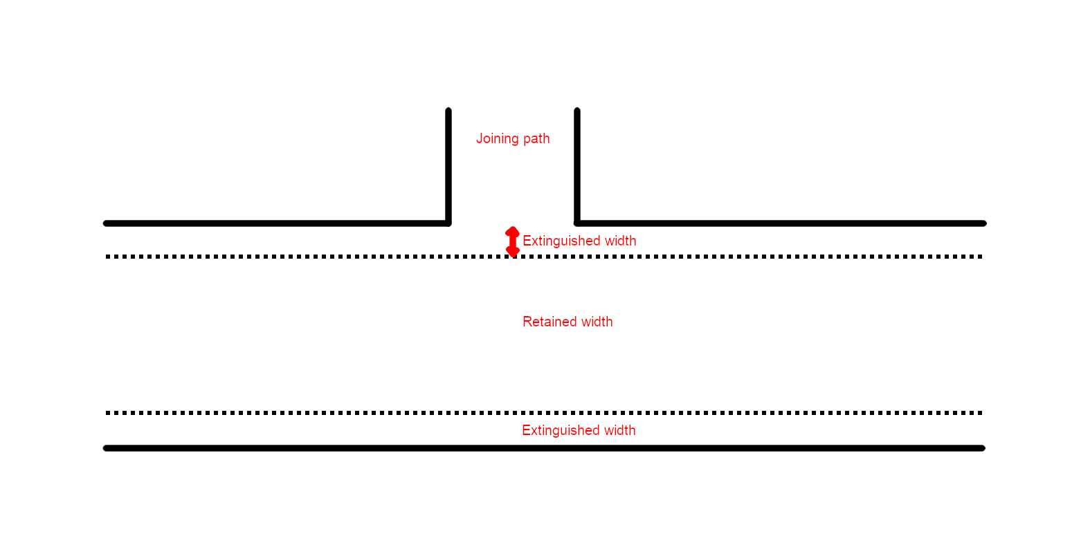
H. Reduced-width footpath or bridleway

H.1. It is a footpath or bridleway, of which part of the width has been stopped up after 1 January 1949.

H.2. It is unusual for part of the width of a footpath or bridleway to be stopped up (and still more unusual that the footpath or bridleway then failed to be recorded on the definitive map and statement).

H.3. A partial-width stopping up probably could be done by a magistrates’ court under s.116 of the 1980 Act, or under s.247 or 257 of the Town and Country Planning Act 1990. It could also be done by a partial width extinguishment order under s.118 of the 1980 Act. It seems that, where part of the width of a footpath is converted to a cycle track under the Cycle Tracks Act 1984, so that part of the width remains unaffected, the exception would not apply, because the converted part of the footpath has not been ‘stopped up’. In that (unlikely) scenario, only the unconverted part of the unrecorded footpath would be extinguished.

H.4. It is not only the footpath or bridleway over which part of the width has been extinguished which is excepted, but a continuation of the same footpath or bridleway to connect with another highway (which is not itself extinguished). For example, a bridleway lies between village A and village B, connecting with no other intermediate highway. Part of the bridleway was set out in an inclosure award at 20 feet wide. A housing estate was built abutting the bridleway in 1968, and the width of the bridleway next the housing estate was reduced to 12 feet by order under s.257 of the Town and Country Planning Act 1990. The bridleway was not added to the definitive map and statement. The whole of that way is excepted from extinguishment.

H.5. But if, in building the housing estate, the bridleway (beyond the reduced-width section) was made to connect with adopted estate roads, then only the reduced-width part, and so much more either side as connects with the adopted roads, will be excepted from extinguishment.

See subs.(2)(d), (3)(a)(i), (3)(b) and (4).

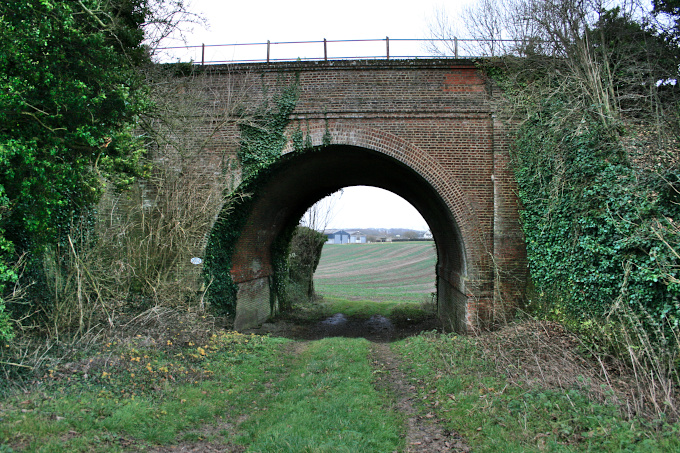
I. Bridges and tunnels

I.1. It is a footpath or bridleway ‘as passes over a bridge or through a tunnel’.

I.2. It is not only the footpath or bridleway which passes over a bridge or through a tunnel which is excepted, but a continuation of the same footpath or bridleway to connect with another highway (which is not itself extinguished). For example, a footpath lies between village A and village B, connecting with no other intermediate highway. Part of the footpath crosses a bridge. The footpath was not added to the definitive map and statement. The whole of that footpath is excepted from extinguishment.

I.3. Neither ‘bridge’ nor ‘tunnel’ is defined by the 2000 Act.

I.4. It appears to be immaterial by whom the bridge is provided. For example, it does not matter that the bridge is owned and maintained by the landowner for his or her own convenience, so long as the footpath or bridleway way passes over it.

I.5. It seems that a bridge need not be of any great substance in order to qualify as a bridge. For example, a plank over a ditch appears to be sufficient. A culvert underneath a path appears unlikely to qualify.

I.6. S.34 of the 2000 Act refers to powers to create a ‘means of access’ to access land, including ‘any bridge, stepping stone or other works for crossing a watercourse, ditch or bog’. If ‘bridge’ is used in the same sense in both s.34 and s.54, it includes quite minor works.

Narrow bridleway passes through narrow arched bridged, with woodland track passing over the top. Sides of bridleway are faced in flint and stone.
Meadow Plat Bridge: the bridleway passes underneath
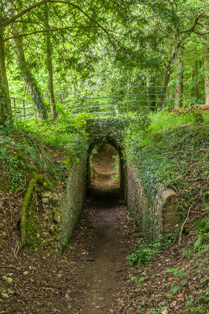
Photo © Ian Capper (cc-by-sa/2.0)

I.7. On the face of it, a tunnel suggests a subterranean passage of some length. (OED: ‘A subterranean passage; a road-way excavated under ground, esp. under a hill or mountain, or beneath the bed of a river: now most commonly on a railway; also in earliest use on a canal, in a mine, etc.’) However, such features are almost wholly absent from the recorded rights of way network, let alone unrecorded rights of way, and it would be surprising if unnecessary provision were made to except from extinguishment. It also would be surprising if a footpath or bridleway over a bridge (such as a railway bridge) were excepted, but not a path under a bridge (again, such as a railway bridge). It is unclear how one would distinguish a long under-bridge from a short tunnel: for example, some of the Lovelace Bridges (East Horsley, Surrey) have the appearance, for users, of tunnels (see, for example, Meadow Plat bridge), but were built as over-bridges for forestry purposes. A cattle creep under a railway line likewise has the appearance of a tunnel (see, for example, the creep at Charlton, Hampshire, which conveys a footpath under the railway).

Small arched tunnel under railway line with vegetation encroaching from the sides
Cattle creep near Charlton (a public footpath)

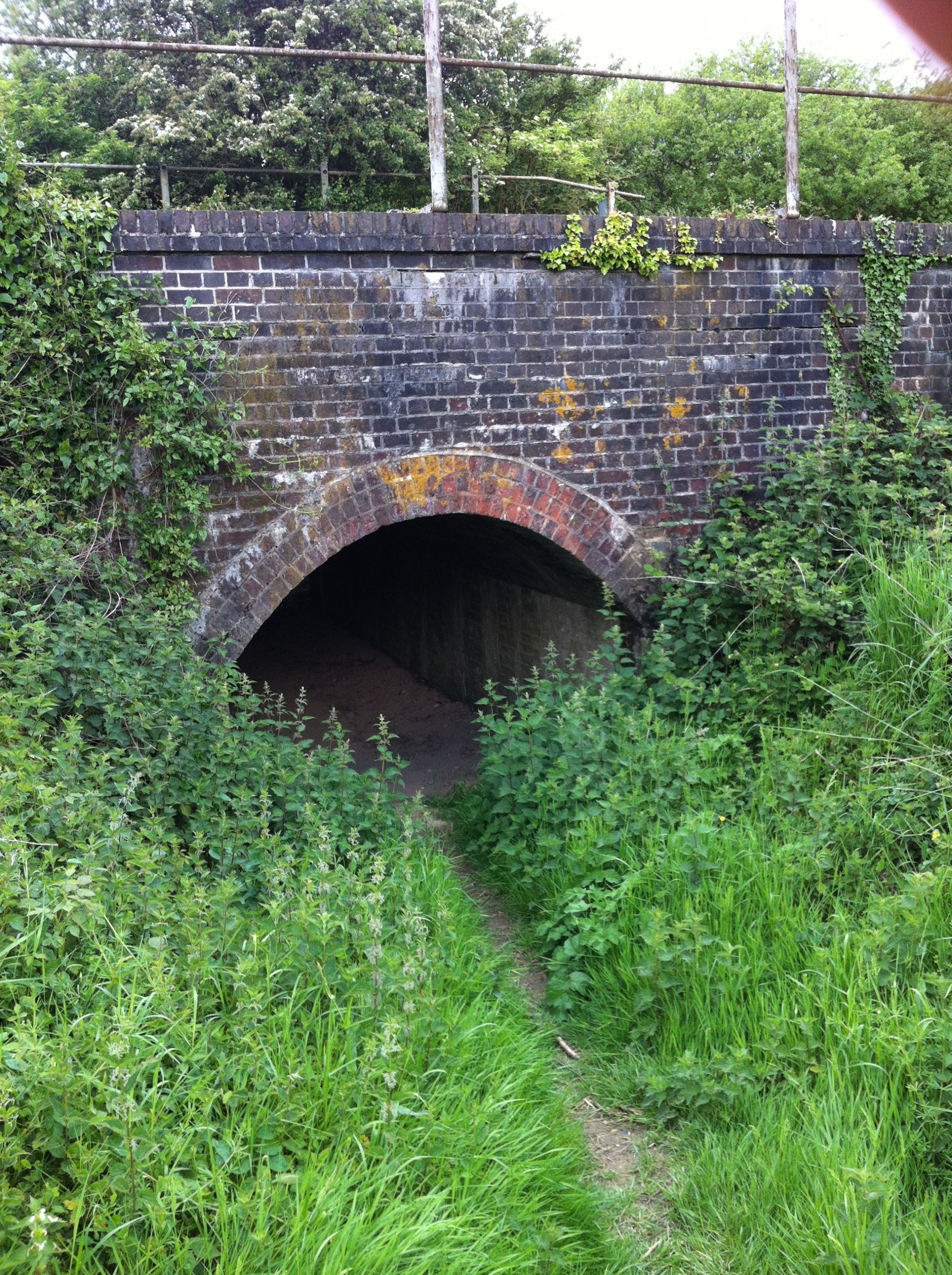
I.8. It is unclear whether the bridge or tunnel must still be in existence at the cut-off date. In the example in para.I.2 above , if it is well documented that the footpath crosses a bridge (being marked on successive editions of the Ordnance Survey County Series plans), but the bridge no longer exists, does the exception apply?

I.9. It is possible that the exception is intended to preserve from extinguishment unrecorded rights of way which benefit from infrastructure provided at public expense, or where such infrastructure was provided at private expense (such as by a railway or canal company) in order to satisfy the public interest in maintaining the right of way. If so, it would be reasonable to interpret a ‘tunnel’ to include an under-bridge, and for such infrastructure still to be in place at the cut-off date—otherwise the effect would be to require, in effect, the replacement of the missing infrastructure at considerable new expense. The use of the present tense in subs.(2)(e) reinforces that conclusion. However, if so, the position is unclear where the decking or cover has been removed from above an under-bridge, so that the infrastructure remains present and passable, but no longer functional (i.e. the roof of the ‘tunnel’ has been removed).

I.10. It appears not to matter whether the pre-1949 footpath or bridleway passed over the bridge, or through the tunnel, prior to 1949. If, for example, the footpath or bridleway passes over a motorway on a bridge constructed (inevitably) after 1949, but on a line which is consistent with the pre-1949 way, this seems to be sufficient to attract the operation of the exception.

I.11. The scope of the exception is uncertain in its impact, so that what might be excepted ranges from a footpath crossing a stream where the footbridge long has been washed away, to a former tunnel under a four-track railway line and sidings, where the line has closed and the decking removed.

See subs.(2)(e), (3)(a)(i), (3)(b) and (4).

J. Created right of way over pre-1949 footpath or bridleway

J.1. It is a pre-1949 right of way over a post-1949-created right of way.

J.2. This is best illustrated by an example. A bridleway lies between village A and village B, connecting with no other intermediate highway. It is pre-1949 in origin, and was unrecorded on the definitive map and statement drawn up under the 1949 Act. In 1972, unaware of the pre-1949 bridleway, the local authority created a footpath along part of the line of the bridleway by agreement under s.25 of the 1980 Act to facilitate access within a new housing estate. The bridle rights over that part of the created ‘footpath’ are excepted from extinguishment.

J.3. No other part of the bridleway benefits (in this class) from the exception from extinguishment.

J.4. Plainly, the exception is of relevance only where the rights which subsequently have been created are of lower status than the pre-1949 rights. If, for example, a public road is created over the line of the bridleway in the example in the previous paragraph, the exception is of no real effect.

J.5. There is an express exclusion from the operation of this exception in respect of the rights conferred for cycling under s.30 of the Countryside Act 1968.

See subs.(5)(a).

25 January 2024: paragraph G.11. added following a recent comment.


2026 and all that

Rights of Way Posted on Thu, 17 February 2022 05:58
Unrecorded way to the west of Lifton church, Devon. No longer at risk of extinguishment?

In East Kent, near Wingham, a small town with mediaeval lineage, a footpath was diverted in the late eighteenth century. Plainly, the footpath irritated the owner of the park which it traversed, and it was diverted to a new alignment which was much longer (although allegedly more ‘commodious’), and barely any shorter than walking along the road. Even at the time, the diverted path passed in front of several cottages, presumably which were tenanted and whose tenants had no say in the matter. There can be little doubt that the old path ceased to be used at this time, but it is far from clear whether the new path became established. It does not appear on the first edition of the Ordnance Survey County Series twenty-five-inch map less than a century later, and its course can only be guessed at from the inadequate plan which accompanies the order. Suffice to say, its ‘imposition’ on the householder who now occupies those cottages (they are just one dwelling today) would be distinctly unwelcome and unexpected.

Strictly speaking, the footpath exists today, for the diversion order is conclusive evidence of its legal existence, and there is no subsequent record of its further diversion or its extinguishment. An application to the surveying authority (in this case, Kent county council) for a definitive map modification order, made under s.53(5) of the Wildlife and Countryside Act 1981, adducing evidence of the diversion order, is bound to succeed. The footpath would have little utility, running parallel to a country lane (whereas the original diverted path avoids an unpleasant walk along the main road). Under reforms promoted in the Deregulation Act 2015, but not yet brought into effect, the surveying authority could suggest a modification consent order to the owners of land affected by the application, which could divert the ‘new’ path to an alternative route, perhaps outside the curtilage of the dwelling. But as the householder does not own the land outside that curtilage, he or she would be ransom to the adjacent landowner, who might agree in return for a hefty fee. In that case, the householder would be no better off than now, by which he or she might seek a diversion order under s.119 of the Highways Act 1980, and accept liability for any compensation which (if necessary) a tribunal might award to other affected landowners.

As it happens, no such application yet has been made, and I do not intend to make one. Others might yet. That this might occur from the chance discovery of an old diversion order in the county archives, arises from the legal principle best encapsulated in the maxim, once a highway, always a highway (cited by Byles J in Dawes v Hawkins in 1860). A highway endures until lawfully it is stopped up under statute, or rarely, where it ceases to exist (as where a cliff-top path subsides onto the rocks below). In that respect, highways are becoming increasingly isolated in retaining their old, common law, rules of continuing subsistence. Over the past 50 years, several other ancient principles affecting land have become regulated into the modern era. Surrender of land to adverse possession is now rendered effectively voluntary in respect of registered land. Unregistered, non-obvious easements across land are not binding on successors in title. Obligations to repair the chancel of a church must be registered. Various land charges must be registered.

That a highway proven to exist in the eighteenth century, or earlier, but not heard of since, can be resurrected in the twenty-first century, is remarkable.  The legal principle fails to discriminate between ways which have been out of use for 250 years (or more), and those which have gone out of use in more recent times owing to obstruction or oversight.  It gives equal weight (in theory) to a rediscovered way across an open moor, and a built-over way through a recently-completed housing estate.

It is doubly extraordinary that the legal principle applies in an era when we have records of known subsisting highways — the list of publicly-maintainable streets held under s.36 of the 1980 Act (which primarily records public roads) and the definitive map and statement of public rights of way held under Part III of the 1981 Act. But neither record is complete — far from it — and the process for adding new ways to either record (whether arising from eighteenth century or contemporary evidence) is cumbersome and costly. Moreover, what is missing from the record is not just long-lost eighteenth century highways, but ways which endured well into the twentieth century. Most of these were omitted from the parish surveys conducted under Part IV of the National Parks and Access to the Countryside Act 1949 either because those in charge of parish councils and parish meetings decided that they were unwanted or troublesome (often the same people in charge as were interested in the land crossed by these ways), or because local authorities convinced them that they were publicly-maintainable roads which ought not to go on the definitive map and statement (some of which subsequently were scrubbed from the record).

It hardly is surprising that Part II of the Countryside and Rights of Way Act 2000 sought to bring some measure of closure to unrecorded highways. It did so (or would have done so) incompletely, by intending to extinguish from 2026, generally speaking, only unrecorded footpaths and bridleways (but not roads) which were in existence in 1949 (and therefore might be proven through the production of historical evidence). But it also did so indiscriminately — an indiscriminate response to an indiscriminate legal principle. It did not distinguish long-existing and well-defined ways from those which have had no physical existence for centuries. And it did not distinguish unrecorded ways which remain in use today (but are pre-1949 in origin) from those which had not been used for centuries — although undertakings subsequently were given to protect the former, just so far as continuing use could be proven to the required degree of regularity and consistency.

The 2000 Act was enacted by the then Labour Government, with a commitment from the Minister that funding would be provided to voluntary bodies to enable them to research and complete the definitive map and statement before 2026 and closure. That funding morphed into a project, Discovering Lost Ways, by the then Countryside Agency (subsequently Natural England) itself to research, identify and record ‘lost ways’, which was brought to a very premature halt on the grounds that the process for claiming and recording rights of way was not fit for purpose and required reform. A stakeholder working group was established in 2008 to consider potential reforms and reported in 2010 (Stepping Forward), and those reforms, allegedly consensual, were enacted in the Deregulation Act 2015. The group’s intention was that these reforms would be delivered and monitored long before 2026, to inform enactment of the cut-off provisions. But endless delay (the group had met once in the last three years) mean that those reforms in the 2015 Act still await implementation.

On 16 February 2022, the group met again, to be informed that Defra has decided not to implement the 2026 cut-off. On the face of it, this is a cause for celebration by supporters of greater access to the countryside. Research into unrecorded ways can continue without any impending closure to new claims. What’s not to like?

Quite a lot. The first downside is that abolition of the cut-off is not sustainable in the long-term. It merely has deferred a mechanism for bringing closure to unrecorded ways, but eventually, and perhaps not before too long, political pressure will build again to enact closure. Whether that will be done according to a constructive, consensually-prepared legislative agenda remains to be seen. Alternatively, perhaps something will be done in an even more damaging form than Part II of the 2000 Act (anyone remember the sudden extinguishing effect of s.67 of the Natural Environment and Rural Communities Act 2006 on public rights for mechanically-propelled vehicles?). Will it allow for a sufficient opportunity to complete the definitive map and statement in every part of England? I am not suggesting for a moment that the present Government will renege on its commitment now to repeal the 2026 measures: but sooner or later, a Government will have to revisit the matter.

What we need is a sufficiently-funded opportunity to properly research and bring up to date the definitive map and statement in each surveying authority’s area. How could that be done? Even now, Natural England has a strong, committed cohort of staff working on completion of the English coastal route. Their roles soon will come to an end. Give them new training on rights of way research (many of them will know plenty already), and second them in turn to surveying authorities to carry out research and process the findings into definitive map modification orders. When their work is done in each authority’s area, close the definitive map to new historical evidence.

The second drawback is that there are no immediate plans to repeal the cut-off provisions in the 2000 Act. Defra will await a suitable legislative vehicle. The provisions will not (Defra says) be brought into force, but in theory, pending repeal, they could be given effect at any time up to 2031 by making a small suite of statutory instruments. There is a significant risk if there is a future change of Government not bound by today’s disclosure, if repeal has not been effected.

The third is that Defra has decided to prioritise implementation of the right to apply for public path diversion and extinguishment orders. The right is conferred on landowners affected by public paths: the tests for making orders remain unchanged, but highway authorities are required to consider every application according to the tests, and with new supportive Government guidance. The right also was enacted in Part II of the 2000 Act, but the legislation was faulty, and required correction in the 2015 Act. It then was coupled with implementation of the 2026 cut-off, and therefore delayed in the same way. Not only will implementation of the right require highway authorities to consider making a diversion or extinguishment order on the initiative of the landowner, but it threatens to divert skilled and experienced rights of way staff, in local authorities, into processing such applications, and the orders which might arise from them. It may also have the same effect on staff and inspectors in the Planning Inspectorate, who will process appeals, and orders referred to the Secretary of State for confirmation.

The fourth is that the reforms in the 2015 Act are not now seen by Defra as a priority. It does not propose to repeal them — but equally, there is no timeline for their implementation. One of those reforms would have been highly advantageous to researchers — they would have been freed of the time-consuming and costly responsibility of notifying the owners and occupiers of land affected by an application (costly because identifying ownership usually means the purchase of titles from HM Land Registry, and service of notice by recorded delivery). Other reforms would have reduced the burden on surveying authorities, responsible for administering the definitive map and statement — they would no longer have been required to advertise public notices in local newspapers, they would have been able to weed out poor quality applications at the outset, and they would have acquired streamlined powers to correct administrative errors in the definitive map and statement.

Arguably, everyone might have benefited from the provision in the 2015 Act for modification consent orders (MCOs) — though perhaps not in the case cited in the opening paragraphs of this blog — which enabled the authority to negotiate passage for a definitive map modification order without objection, by agreeing with the landowner a package including any combination of diversion, reduced width and additional limitations (such as gates) not justified by the historical evidence. While MCOs were not obviously in the interests of the applicant for an order, they did offer an opportunity to ameliorate the embarrassment which might be caused by an application for a route which had a marked impact on land management or enjoyment.

None of these 2015 Act reforms necessarily now will be introduced. Some of them might be pursued at a later date, but only if it legally is achievable. For example, it has been suggested that provision for MCOs could be enacted in isolation, and indeed, it is contained in a free-standing insertion of ss.54B and 54C into the Wildlife and Countryside Act 1981 (see para.5 of Part 1 of Sch.7 to the 2015 Act). But those sections rely on the parallel implementation of Sch.13A and Sch.14A to the 1981 Act — and in my view, those Schedules are indivisible and now unlikely ever to be implemented. It is not entirely clear that transitional provision could be made modifying references to those Schedules, if the true intention is not to give effect to those Schedules at all.

In short, Defra risks throwing the baby out with the bathwater. A wide range of reforms, seen as essential irrespective of the cut-off date, now may never see the light of day. There is cause for all interest groups to lament this potential outcome.

The fifth objection is that the glacial processing of the group’s reforms has enabled Defra to sideline everything to do with rights of way for ten years or more. Any identified need for reform has either been referred to the group, or pigeon-holed for later. Revision of the Consistency Guidelines (the Secretary of State’s policy on interpretation of historical evidence) has been referred to the group: will it ever grapple with the guidelines? New regulations on public path orders were being drafted as a necessary consequence of the reforms, bringing a welcome opportunity to update and modernise, but very likely, now there will be no vehicle at all for changes. An update to Defra Circular 1/09 on rights of way was on the agenda: now perhaps nothing will emerge. After all, Defra now will be focused on bringing the right to apply into force. Above all, the proposals for monitoring the 2015 reforms, which surely would have shown that ever-diminishing capacity in surveying authorities has derailed the entire process, will not now take place.

The sixth and final objection is that abolishing the 2026 cut-off may engender a sense that now there is no reason to press on quickly with historical research. Researchers and user groups may let up on the throttle. Surveying authorities may divert resources to higher profile activities (such as obstructed paths, or processing public path orders — see above). That may be particularly regrettable if a future extinguishing provision is enacted with much less notice and fewer protections.

There still is cause for limited celebration. The 2026 cut-off was poorly targeted and would have had colossal unintended consequences. It is right to abolish it. But it is not the end of the story.

Postscript: On 22 March 2023, Defra sort-of announced (without making any announcement) that the 2026 extinguishing legislation would be implemented after all, but with the cut-off date set back to 1 January 2031. (It subsequently published a low-key blog on 24 March.)


Extinguishing effect on widths of paths under Part II of the Countryside and Rights of Way Act 2000

Rights of Way Posted on Sun, 20 June 2021 19:15

Part II of the 2000 Act widely is understood to extinguish, by default in 2026, public paths which are not recorded on the definitive map and statement — subject to as yet unspecified savings for, for example, paths the subject of pending applications for definitive map modification orders. What is less widely understood is that, in 2015, Defra adopted the position that Part II also extinguishes any unrecorded widths of public paths — that is, any width which exceeds that recorded in the definitive statement (if any width is recorded at all). Defra has proposed that the extinguishing effect on width should be subject to a saving for such width ‘as is necessary for the safe and convenient passage of the public’. This blog analyses what impact the extinguishment of unrecorded width might have.

Black Lane, Knowlton was recently recorded on the definitive map and statement with a width (here) of 11 metres. If it had been recorded as no wider than the metalled carriageway (say 3 metres), it could, after 2026, be fenced in to precisely that width.

A. Introduction

A.1. Section 53 of the Countryside and Rights of Way (CROW) Act 2000 extinguishes certain unrecorded footpaths and bridleways of historical origin.

A.2. The Stakeholder Working Group (SWG) has been informed that s.53 bites to extinguish the unrecorded width of footpaths and bridleways of historical origin (i.e. pre-1949) which are nevertheless recorded on the definitive map and statement.

A.3. This is an analysis of the effect of s.53 in relation to unrecorded width.

A.4. Reference is made below to a ‘true width’ of a right of way, meaning the width which may be established either by dedication (express or deemed), or by statutory origin (such as an inclosure award or diversion order where a width expressly is given).

A.5. Reference is made below to ‘public paths’, meaning footpaths and bridleways (only).

A.6. ‘EEW’ refers to the extinguishing effect on width — see para.C.1 below; ‘SCW’ refers to the ‘safe and convenient’ width — see para.E.19 below.

B. The origin of widths in the definitive statement

B.1. Part IV of the National Parks and Access to the Countryside Act 1949 (the ‘1949 Act’) called for the preparation of the draft, provisional and definitive map and statement of public rights of way by surveying authorities, relying (s.28) on the provision of information by, inter alia, parish councils and parish meetings.

B.2. S.27(4) required the surveying authority to prepare:

…a statement…containing…such particulars appearing to the authority to be reasonably alleged as to the position and width [of public rights of way shown in the map], or as to any limitations or conditions affecting the public right of way thereover, as in the opinion of the authority it is expedient to record in the statement.

B.3. S.31(1)(c), (3)(c) and (5) provided for appeals to quarter sessions against the width entered in the provisional statement. S.32(4)(c) provided that:

…any particulars contained in the [definitive] statement as to the position or width [of a right of way] shall be conclusive evidence as to the position or width thereof at the relevant date…

B.4. The width of a way specified in the definitive statement is most likely to have derived from the parish survey conducted under s.28. What was recorded in the parish survey may follow from a conscientious assessment of the true width of the way, a guess or general statement of its width, or a standard formula (such as that every footpath has a width of 2 feet). Even where the width recorded in the definitive statement arises from first-hand assessment during the Part IV survey, it should not be assumed that the recorded width is reliable. It is unlikely that, on a survey of parish paths, the surveyors (in practice, parish councillors, volunteers or user group representatives) made detailed measurements of the paths. On a cross-field path, a width might be recorded which reflected the extent of any worn path on the ground; on an enclosed way, a width might be estimated as the average width between the boundary fences, walls, hedges or ditches. Even if measurements were taken, it is unlikely that they were repeated at regular intervals. The width recorded is highly unlikely to be, nor intended to be, an accurate measurement of the entire width of the way throughout its length. Indeed, it might be qualified in terms: ‘average width of 16 feet’; ‘worn path 2 feet wide’; or ‘2 foot path within lane 12 feet wide’.

B.5. Where no width was recorded in this parish survey, it is possible that a width was inserted by the surveying authority. As it is unlikely that the authority had the resources to measure every way, such a width was more likely to adopt a standard formula than an attempt accurately to record the width of the particular way.

B.6. It should be noted that, even assuming that a surveyor was equipped to take measurements, and that those measurements faithfully were recorded in the definitive statement, the surveyor incorrectly may have relied on physical features in order to make an informed assessment of the true width. In relation to a cross-field footpath, the worn width of the way might be no more than was rolled out by the farmer in that particular year; in relation to an enclosed lane, the true width might lie between the roots of the hedges and not between the inner sides of the ditches within the lane.

B.7. In relation to rights of way in the West Riding of Yorkshire, a decision was taken1 that any footpath recorded (in the draft statement) with a width of more than 6 feet summarily was to be reduced to 4 feet, and bridleways likewise more than 10 feet wide to 8 feet,

‘to define the liability of the highway authority within the limits of ways which in some cases are 20, 30 and sometimes more feet between fences.’

Subsequently, it appears that the reduced width was imposed only where an objection was made by the district council — but many such objections were made, instigated by the highway authority. Thus the decision acknowledged that the true width of those ways was often much wider. These ways now are recorded in the definitive statement with a width of 4 feet (for footpaths) and 8 feet (for bridleways). It is calculated that at least 2,140 modifications of width or status or both were made by, in effect agreement between district and county council, in the West Riding area.2

B.8. It has been suggested that other surveying authorities adopted a standard width of, for example, 2 feet in relation to every public footpath in their area — even where the footpath followed a green lane or road. 

B.9. The recorded width, if any, therefore is not necessarily a reliable or useful guide to the true or historical width of the way. It may bear no relation whatsoever to either measurement.

C. Extinguishing effect on width

C.1. Section 53 is said to have possible effect in extinguishing all or part of the width of a right of way in two circumstances:

  • where a way is recorded in the definitive map and statement but with a width defined in the statement being less than the true width;
  • where a way is recorded in the definitive map and statement but with no width specified (a ‘null width’).

This is referred to below as the extinguishing effect on width — the EEW.

C.2. This analysis does not review the correctness of the EEW as such, but proceeds on the assumption that it is correct in relation to the first case, and argues that it is untenable in relation to the second case.

C.3. In relation to the second effect, the EEW (if there is an EEW) must have effect to extinguish the way in its entirety. In the absence of any saving provision to moderate the effect of the EEW, there can be no half-way house — either the entire way is extinguished for want of a defined width in the definitive statement, or it is unaffected

C.4. It is understood that the recording of rights of way with a null width is so widespread that an interpretation which infers the extinguishment of all such ways (if they are of historical origin) in the absence of a saving provision appears inherently absurd and contrary to the intention of Parliament. There is a presumption against Parliament legislating for an absurdity, and:

the strength of these presumptions depends on the degree to which a particular construction produces an unreasonable result. The more unreasonable a result, the less likely it is that Parliament intended it3

C.5. Such an interpretation cannot be rendered acceptable if that rendering is achievable only by the enactment of a saving provision in secondary legislation which heads off the outcome effected by s.53 itself. Delegated legislation may be used as an aid to interpretation primarily where it is contemporaneous with the Act.4 Were it clear during the Parliamentary stages of the CROW Bill that it was intended to make regulations to moderate the effect of s.53 in relation to unrecorded widths, it might be possible to make a case that, taken together — the Act and the proposed regulations — were intended to extinguish rights of way with a null width subject to a specified saving of partial width. But not only was no such intention evinced at the time, and draft regulations to give effect to such a saving not published until nearly 20 years later, but (as noted above, and see section D below), there was no perception of any EEW at the time of the CROW Bill, or in the years following its enactment. Moreover, full effect can be given to s.53 for the purpose to which it is plainly addressed (‘Extinguishment of unrecorded rights of way’5) without interpreting it to have full extinguishing effect in relation to ways which are recorded with null width.

C.6. Thus it is submitted that s.53 must be interpreted without recourse to the moderating effect of any implementing regulations, and that, if there is an EEW, only the first effect is tenable. Therefore, only the first effect here is considered further.

D. Acting on the extinguishing effect on width

D.1. Part II of the 2000 Act does not make any express provision to extinguish unrecorded width of any right of way.6 Nor do the explanatory notes address any such provision inherent in the legislation. No reference was made to any EEW during the debates in Parliament on the Countryside and Rights of Way Bill.

D.2. The report of the SWG7 does not address or refer to the EEW.

D.3. The author does not recall any articulation of an EEW prior to, during or in connecting with implementation of the 2000 Act.8

D.4. Accordingly, it appears that the earliest intimation of such EEW was its disclosure to the SWG (believed to be in 2015). On 22 December 2015, Jonathan Tweney of Defra circulated a note to the SWG,9 which summarised the view of Defra lawyers and counsel that there was no EEW in relation to the first case, but an EEW in relation to the second case (see para.C.1 above), and concluded:

The question is do we need an exception for under-recorded widths ie where the width recorded is less than the true width, such that they are saved from Section 53 extinguishment.

D.5. The questions which arise in this paper are broader: whether it is appropriate that the 2000 Act should have an EEW, and what might be done about it.

D.6. As to the first, approximately 15 years (or about three-fifths) of the 25 years allowed under the 2000 Act have passed without anyone (including those in Defra responsible for the legislation) having knowledge of the EEW (or if such knowledge did exist, raising awareness of it).

D.7. As to the second, it can safely be said that there is no awareness of the EEW outside the SWG, and no steps have been taken, by any party, to address it.

D.8. Moreover, even if such awareness were widespread, how would practitioners know what ways were threatened with partial extinguishment? And how would candidate public paths for research and safeguarding (through application for definitive map modification orders) fare with a little under five years until the cut-off date (one-fifth of the time originally allowed), set against the challenge of many other ways which would be extinguished altogether?

D.9. Few are familiar with the recorded width of public paths in the definitive statement. Even those who regularly work with the definitive map might rarely check with the details of width in the statement, save where a particular issue arises — for most, it is enough that the way is recorded on the map. Thus candidates for the EEW generally will be unknown.

D.10. In some surveying authority areas, candidates for the EEW may be commonplace, where (it is said), the authority habitually recorded a standard width on the draft definitive map under Part IV of the 1949 Act (e.g. 2 feet) regardless of the context. In others, they may be uncommon, where steps were taken to estimate the true width during the Part IV survey, and to research documents showing historical origin. Therefore, in order to identify candidates, a detailed survey would be required of all public paths compared with the definitive statement, and research carried out to identify those public paths which are attributable to an abstract specified width as opposed to survey.

D.11. Alternatively, a view could be taken that little or nothing should be done to prevent the EEW (perhaps by prioritising the safeguarding of unrecorded historical ways). If no saving provision were included in implementing legislation, then — where relevant — the EEW would substitute the width given in the definitive statement for the true width. In some contexts, this would substitute a width which bears no relation to need (e.g. 2 feet for a bridleway), or which leaves the way vulnerable to inclosure at an insufficient width (e.g. fencing a cross-field footpath to a width of no more than 2 feet).

D.12. Alternatively, if a saving provision is conferred, see the discussion which follows.

E. Analysis of the extinguishing effect on width

E.1. This section explores the issues which may arise from the EEW.

What is extinguished?

E.2. If part of the width of a public path is to be extinguished, the question arises as to which part will be extinguished? If, for example, a path is recorded with a width of 1 metre, but its true width is 3 metres, what is it which is extinguished in reducing the path with from 3 metres to 1 metre? Is the width reduced equally from both sides? So that 1 metre is eroded from one side and a further metre is eroded from the other side? Or is all the width lost from just one side? As there is no process prescribed in the legislation to apply the reduction in width to the specific circumstances of a particular public path, it must be assumed that the legislation works in the same way in relation to every path.

E.3. It may be that the definitive statement records the width of a public path in relation to defined features: for example, ‘3 feet out from the wall on the south side’. In that case, the EEW might be expected to have effect in relation to any part of the true width which lies beyond the recorded width (i.e. anything beyond 3 feet from the wall). But this will be exceptional.

E.4. If, say, a green lane bridleway is recorded in the definitive statement as ‘3 feet’ and the green lane is 12 feet wide, it could be said that the 3 feet is whatever 3 feet were in use at the time of the Part IV survey. If the path at the time of the survey then ran up the side of the green lane, then the retained 3 feet (following the EEW) would be the ‘original’ 3 feet at the side of the lane (and not a three foot strip up the middle). Of course, what part of the green lane was in use at the time of the Part IV survey may not be consistent with the part that is in use today, or indeed, pre-1949. Theoretically, this approach has some merit, in that it relates the definitive width to what was perceived at the time of the Part IV survey. But in practice, it is completely impossible to operate for want of knowledge of what was being used 70 years ago. If it were to be the correct approach, then plainly it is unworkable.

E.5. It is submitted that the only plausible and logical effect of a reduction in width, where the width in the definitive statement is not defined with precision in relation to any particular physical feature, is that the width equally is pared away from both sides of the path. While there may be circumstances (as to which, see immediately below) where it would make more sense if the width were lost entirely from one side of the path, it is impossible to conceive how the legislation could not have a universal impact applicable in every case.

E.6. This universal impact will have curious and undesirable effects. For example:

  • If the path physically is enclosed on both sides, half the width will be extinguished between the fence (or other delimiting obstacle) and the new boundary of the path on each side, notwithstanding that the extinguished width on either side is unlikely to be of any use to any person other than the public using the path.
  • If the path physically is enclosed on one side, half the width will be extinguished between the fence (or other delimiting obstacle) and the new boundary of the path on that side, again notwithstanding that the extinguished width is unlikely to be of any use to any person other than the public using the path. Whereas the owner of the land on the unenclosed side of the path will gain only the other half of the extinguished width.
  • If the path comprises a metalled way eccentrically located within a broader strip of highway, or simply is maintained so that only a narrow trod is available to one side of the strip, it may be that part or all of the extinguished width will Include all or part of the metalled way or trod. Thus, what is left may comprise only the unimproved surface of the highway.
Illustration 1: Church Lane, Sholden, Kent

E.7. The photograph above shows Church Lane, recorded as a footpath. No width is recorded in the definitive map and statement, but let us assume that a width is recorded of 2 feet, and that the boundaries of the true extent of right of way are comprised in the wall and hedge on each side, amounting to a true width of 15 feet. If we are correct to infer that the EEW will occur on both sides of the right of way, what will be preserved is a 2 foot strip roughly centred on the right hand side of the paved footway. If a saving operates to preserve a greater extent, presumably what will be preserved is unlikely to be greater than the width of the paved footway (say 8 feet). Nevertheless inevitably some part of that paved footway will be extinguished, because half of what remains to be extinguished must be lost from the left hand side of the true extent of the right of way as a whole.

E.8. It is not clear what will be the outcome where a public path subject to the EEW is joined by another public path: see the example in Illustration 2 below. It seems that the EEW may cause part of the width of the path to be extinguished at the junction with the joining path (as elsewhere), creating a discontinuity between the two paths.

Illustration 2: Path junction affected by EEW

How much is extinguished?

E.9. What is extinguished must be that part of the way which is not recorded in the definitive statement as part of the specified width of the way (but see above about what part is extinguished).

E.10. Any saving contained in regulations may reduce or abrogate the EEW, to the extent that there may be no reduction in width whatsoever.

E.11. As we have seen (section B above), what (if anything) is recorded in the definitive statement as the width of a public path is by no means likely to be an accurate measurement of the true width of the path at the date of the Part IV survey. It may be a casual estimate of the path width, a guess as to width, an assessment of width of part of the path (only), or an administrative convenience. Nevertheless, the EEW removes such of the true width of the path which is not specified in the width entered in the definitive statement.

E.12. It is not clear what is the EEW where the width specified in the definitive statement is:

  • uncertain (e.g. ‘average width of 5 feet’) or variable (‘between 5 feet and 8 feet wide’, or ‘narrowing from 8 feet to 5 feet’);
  • not necessarily intended to specify the full width of the way (e.g. ‘tarred path 3 feet wide along green lane’);
  • of uncertain extent (e.g. where a way is specified with an initial width of 12 feet along a farm drive, but later diverges from the farm drive without any acknowledgement of a change of width);
  • ambiguous (it is commonplace in Surrey that the definitive statement includes both a ‘width’ and a ‘width fence to fence’).

E.13. Leaving aside any saving for unrecorded width (see below), the EEW may reduce the width of a public path to less than what is necessary to its use. This is a particular issue for horse riders: if the recorded, i.e. beaten width, of a bridleway is say 1 metre or 3 feet, then any further width will be subject to the EEW. If such a way is fenced to the recorded width, it will be impossible for two riders to pass. Moreover, if the path is of any length, and riders cannot, or do not, see that another rider is approaching from the other end, the situation will be quite serious — at best, one rider would have to dismount and coax the horse to back up over a possibly considerable distance, an action which is no more natural nor comfortable for a horse than for a human.

E.14. Many footpaths have been recorded with a width of say 2 feet. Such a width leaves insufficient room for two people to pass save with varying degrees of embarrassment, depending on the size of the individuals concerned.

E.15. If any public facility, such as a bench, post box or notice board, lies within the unrecorded width, the facility both would be isolated from public access, and (if installed reliant on powers in relation to highways) liable to be removed or relocated. Similar considerations might arise in relation to other features, such as a public well or access to water for livestock.

E.16. Where highway structures lie within the unrecorded width — such as ditches, drains, safety barriers, gates, stiles — these will cease to form part of the highway. The owner of the unrecorded width cannot be obliged to maintain (for example) a ditch which drains the highway, but forms no part of it.

E.17. It seems likely that many items of highway furniture, intended to control or facilitate passage by highway users — particularly gates and stiles — will be sequestered within the unrecorded width, or partly within it and partly within the remaining width of the highway. If so, the responsibility of relocating such furniture presumably lies with the landowner.

A saving for unrecorded width

E.18. It has been proposed that regulations might except from the EEW the unrecorded width of a public path in specified circumstances. At the time of writing, current drafting proposes that what should be excepted is:10

So much of the part of the [unrecorded] width…as is necessary for the safe and convenient passage of the public

E.19. Such provision of a ‘safe and convenient’ width (SCW), if made, could have a mitigating impact on the EEW. How would it operate?

E.20. The first point to note is that the SCW saving would operate only on the unrecorded width of the public path.

E.21. It is not stated in the draft regulation what SCW would be ‘necessary for the safe and convenient passage of the public’. A determination of the SCW must be applied as at the date of the cut-off (even if the determination itself is not made until later — as inevitably will be the case). Thus, for example, a cross-field footpath must, at the cut-off date, have some innate SCW, and if, ten years after the cut-off date, a definitive map modification order is made to determine the width of the footpath, that the footpath has now been fenced on both sides is irrelevant — the determination of the SCW is founded in a SCW as at the cut-off date.

E.22. As time elapses after the cut-off date, a determination of what was the SCW at the cut-off date will become increasingly difficult, where the context of the public path has been developed or otherwise modified — just as it is increasingly difficult to identify roads ‘whose main lawful use by the public during the period of [2001–06] was use for mechanically propelled vehicles’, for the purposes of establishing whether there was an extinguishing effect on public rights to use mechanically propelled vehicles.11

E.23. It is unclear whether the SCW might vary between public paths in different contexts. For example, it might be said that a footpath along a cliff-top ought to have a greater SCW than one along the edge of a grazed pasture. But that argument may rely on the special context of a cliff-top footpath, where the footpath lies close to the edge of the cliff-top, and the EEW would pare away at the offside width further away from the cliff-top, as well as the nearside next the clifftop.

E.24. But would a cross-field footpath, or bridleway, have a greater or lesser SCW than one enclosed between fences? It is not obvious that it should, in that the SCW ought to take account of the space necessary to ‘safe and convenient passage’ regardless of whether the public path is bounded by physical features. So for example, BHS guidance states that12:

A useable width [of 3m for a bridleway] is likely to require at least an additional half a metre to each side giving an overall width of 4 metres (bridleway)…to avoid such as overgrowth reducing the useable width between cuts, particularly adjacent to barbed wire or thorny plants… .

E.25. It is submitted that such widths cannot be reduced on the basis that the bridleway is not physically constrained, if the effect is that, in order to maintain ‘safe and convenient passage’, a user may need to trespass off the extent of the highway.

E.26. Would a public path along a farm track demand a greater safe width than one following a discrete alignment solely for path users? For example, if a horse rider met a combine harvester using the track, the rider might need the whole of the true width (and more) in order to enable safe passage. Even a horse rider passing a motor car might demand 5 metres in width to enable passage

E.27. But note that, where a public path becomes subject to use by vehicles after the cut-off date, the SCW will be what was necessary at the cut-off date, and cannot be influenced by subsequent change of circumstances (unless perhaps those changed circumstances reasonably were foreseeable at the cut-off date — for example, if planning permission had been granted for development). Similarly, if a bridleway is seldom used by horse riders or cyclists at the cut-off date, but owing to local development, becomes frequently used by both some years later, no account can be taken of the increase in use in determining what was a SCW at the cut-off date.

E.28. The likelihood is that the proposed saving for a SCW would demand specific consideration in relation to every public path subject to the EEW, even if, in the majority of cases, the outcome ought to be consistent between public paths of the same status and context.

E.29. But the identification of the safe width will remain unknown until some subsequent cause for determination (such as the confirmation of a definitive map modification order, or a successful prosecution for partial obstruction). Until such a determination is made, the legal width of a way affected by the EEW can be only a matter of conjecture: it will be a width which is not less than the recorded width, and not greater than the true width, and it will be a width which is sufficient for ‘safe and convenient passage’.

E.30. It may be assumed that the EEW will lead to a number of applications for definitive map modification orders to record the amended widths where the EEW is known to have had effect, although land owners and occupiers may generally be content to rely on the recorded width shown in the definitive statement. Thus it seems more likely that such applications will be sought by path users, and their representative organisations.

E.31. Because the EEW was not contemplated during passage of the CROW Bill, the regulatory impact assessment does not consider or quantify its effect. It is submitted that the regulatory impact assessment for implementing legislation should do so, taking into account any proposed savings.

E.32. In practice, the effect of the EEW taken with the saving for a SCW will be to substitute for what is often either known (e.g. a width stated in an inclosure award) or unrecorded but discoverable evidence (e.g. the width of a green lane between walls), with a value which is uncertain (the width recorded in the definitive statement, together with the SCW). Given the likely scale of the EEW, that substituted width may never be determined and recorded.

Bespoke savings

E.33. Further provision could be made to provide savings for bespoke contexts, including to address some of the issues noted above. A saving provision could diminish or exclude the operation of the EEW in specified circumstances.

E.34. Such provision would need to operate in precisely identifiable circumstances, and moreover, in circumstances which might need to be identified as having subsisted at the cut-off date, if the legal width of the way is to be determined by a definitive map modification order (or in any other needful situation, such as a planning consent allowing for development either side of the public path) many years later.

E.35. A saving provision which expressly addresses the context of Church Lane, or similar contexts, might provide that less of the paved footway is extinguished, and more of the grassy verge. But such provision would need to be tailored to that particular context, and would raise potential difficulties — for example, what sort of surface would quality, how wide, for what distance (compared to the path as a whole), and in what state of repair?

E.36. A saving provision theoretically could address a context where the beaten bath were eccentrically positioned within the true width of the way. But it is hard to conceive how such provision satisfactorily could address a context which may be ephemeral. It is not unusual, for example, for the beaten path within a wider corridor (for example, an overgrown green lane) to vary over time, the alignment being affected by, for example, private vehicular use, fallen trees, highway authority vegetation cutting activity and encroachments. If the part of the way to be subject to the EEW were to be defined by that part in use at the cut-off date, it is not obvious how that part could be identified many years later for the purposes of a definitive map modification order.

F. Grant of private rights

F.1. It has been proposed that, where a way is extinguished on the cut-off date, provision should be made to preserve a private right of way, where13:

immediately before that extinguishment, the exercise of the right of way— 
(a) is reasonably necessary to enable a person with an interest in land to obtain access to it; or
(b) would have been reasonably necessary to enable that person to obtain access to a part of that land if the person had an interest in that part only.

F.2. It is not clear whether such provision would apply in the context of the EEW.

F.3. Where a landowner, as frontager, owns land adjoining a public path subject to the EEW, and the frontager’s title may be presumed (or is recorded as) extending to the centre line of the path,14 the frontager is entitled to access to the path from that land.15 The EEW will have no effect on the frontager’s access to the path, because the frontager owns the land at the side of the path over which is extinguished the public right of way. Any difficulties which might conceivably arise in relation to a tenancy of the frontager are not explored here.

F.4. But what if the frontager does not own the land comprised in the public path itself — if, for example, the land comprised in a public path is registered as belonging to another party? The EEW will create a thin ‘ransom strip’ between the frontager’s land and the public path — perhaps no more than a few centimetres wide.

F.5. In such a case, it may be that provision to preserve a private right of way may secure the frontager’s access to the public path. If so, it is not clear how it would operate. In relation to a public path subject to extinguishment on the cut-off date, it is clear that the provision operates to preserve a private right of way over the extinguished public right of way. But in relation to the ransom strip, does the frontager acquire a private right of way over the entirety of the ransom strip, or only over enough of it to maintain convenient access? If the latter, where is the right of way granted in relation to the length of ransom strip? Would it lie opposite to an existing gate giving (former) access onto the public path, and if so, how wide? What if (prior to the cut-off date) there were two or more such gates? What if there were no physical barrier, and the frontager took access wherever it happened to be convenient?

F.6. If a private right of way were granted, and applies along the length of the ransom strip, then the owner of that ransom strip (and of the public path) potentially is placed in a still more inflexible place than were it still subject to a public right of way, because any variation to the private right is a matter for negotiation with the frontager, and not subject to variation by a public path order.

F.7. Not all requirements to preserve access over the ‘ransom strip’ would be satisfied by the conferral of a private right. For example, if the public path abuts a public park or other public place, but the whole width of the public path lies in separate hands to the public place, any EEW is likely to sever access from the public path to the public place. It is not clear that a private right of way, such as is proposed to be conferred on the owner of the public place (for example, the local authority), would be sufficient to enable general public access over it.

G. Other exceptions to extinguishment

G.1. The EEW may be excluded if the right of way is otherwise excepted from extinguishment. For example, it is expected that ways recorded on the list of streets16 will be excepted from extinguishment.17 Thus it might be expected that ways recorded on the list of streets (but with a width less than the true width specified in the definitive statement) will also be excluded from the EEW. But if so, the provision will lack coherence: why should the EEW have effect on a way with a width less than the true width specified in the definitive statement, but not if the way also appears in the list of streets — which itself contains no specification of width?

G.2. Similarly, consideration is being given to whether ways in urban areas should be excepted from extinguishment. It might then be expected that such ways will also be excluded from the EEW.

G.3. It is further expected that historical ways which remain, broadly speaking, in regular use will also be excepted from extinguishment.18 It is unclear whether such an exception could be applied to any right of way otherwise subject to the EEW. If, potentially, it could, it would raise the question of whether, and if so, what evidence would be required to show that the full, or some lesser, part of the true width of a right of way, beyond the width recorded in the definitive statement, remained in regular use at the cut-off date.

G.4. For example, where the full width comprises a metalled road, it might be inevitable that the full width remains in regular use, and would be excepted from extinguishment. But what if part of the road were obstructed by a shipping container for a period of some years prior to the cut-off date — would that be sufficient to prevent the exception arising, and if so, over what distance (apart from the length of the container itself)?

G.5. In relation to Church Lane (see Illustration 3 below), what evidence would be required or could be adduced that the grassy verge remained in regular use (as opposed to the paved footway)? Would such evidence be required in relation to every part of the grassy verge, so that the right of way over parts might be found to have been extinguished (for want of evidence of regular use), and that over other parts might not?

Illustration 3: Church Walk, Thames Ditton, Surrey (courtesy Jack Cornish)

G.6. Church Walk in Thames Ditton (Illustration 3 above) is designated Esher footpath 19. The definitive statement records a width of 14 feet.19 Parts of the footpath exceed 14 feet in width between (typically) the picket fences associated with dwellings with frontage along the footpath. It may be that the EEW will be excluded in its operation here because of any of the above exceptions to extinguishment (but it is not obvious how any width additional to 14 feet would be necessary to a SCW). Assuming that it is not excluded, the EEW will enable frontagers to move forward their picket fences by one half of the extent of the EEW.

H. Conclusion

H.1. It is suggested that:

  • The EEW, so far as it has effect, is an unintended consequence of the legislation.
  • The EEW was unknown until recently, and still remains generally unknown.
  • No steps have been taken to preserve public paths from the EEW, by seeking to record the true widths of EEW-candidate public paths, because there has been no understanding of any need to do so, and the identification of EEW-candidate paths is beyond the capacity and resources of the public, user organisations and surveying authorities.

H.2. The EEW, if given effect, even with a saving for SCW, will have a widespread effect on public paths so as to reduce width to a SCW, where the EEW confers no real benefit on any person — such as in relation to enclosed tracks and green lanes. But it will also enable landowners to enclose land from public paths which is recognisably ‘public’.

H.3. Notwithstanding savings, the EEW will have numerous unintended consequences, such as extinguishing the very part of a wide public path which is kept clear for public use, or causing a public bench to be isolated on now private land.

H.4. These consequences are likely in some cases to be high profile, and reflect poorly on Government, local authorities, and the landowners concerned.

H.5. The outcome of the EEW will not create greater certainty about the width of public paths, but less. Many public paths eligible for the EEW will acquire an undefined width which is known to be of or less than the true width, but of or more than the width given in the definitive statement. That width will be incapable of determination without costly public proceedings.

H.6. Therefore, it is submitted that:

  • If the EEW is indeed a consequence of s.53, it should be excluded from operation.
  • If the EEW is not excluded from operation, its impact will be so widespread, arbitrary and unfathomable that, far from delivering greater certainty about the extent of public rights of way, it will diminish and harm such certainty.


————————


Footnotes

1 Memo of the West Riding County Engineer and Surveyor, addressed to the county clerk, of 2 December 1954.

2 Failure to record rights under NPACA 1949 in the West Riding, National Federation of Bridleway Associations Paper 2, March 2007. The figures do not include Area 4 (Barnsley, Royton etc.). The modifications were not required to be advertised.

3 R (on the application of Edison First Power Ltd) v Central Valulation Officer, [2003] UKHL 20 per Lord Millett at para.117.

4 Hanlon v Law Society [1981] AC 124

5 Heading to s.53.

6 S.54(2)(d) provides that an historical right of way is not extinguished if part of that way was stopped up after 1949 as respects only part of its width. It therefore is not an extinguishing provision, but a saving provision as respects the entire way.

7 Stepping Forward, 25 March 2010

8 The author worked in Defra (and its predecessor, DETR) between 1998 and 2003 on Part I of the 2000 Act, and had regular contact and discussions with those involved in Part II.

9 The question of widths and the potential impact of CRoW Section 53 extinguishment at the 2026 cut-off date.

10 The Excepted Highways and Rights of Way (England) [draft] Regulations, product 4b exceptions version_5b 180318, rr.5 and 6.

11 Natural Environment and Rural Communities Act 2006, s.67 (see the exception to extinguishment specified in subs.(2)(a)).

12 BHS guidance on Dimensions for width, area and height

13 The Excepted Highways and Rights of Way (England) [draft] Regulations, product 4b exceptions version_5b 180318, r.9. R.9 is modelled on the Natural Environment and Rural Communities Act 2006, s.67(5)–(7).

14 i.e. applying the presumption ad medium filum.

15 Marshall v Blackpool Corporation [1935] AC 16.

16 Held under s.36(6) of the Highways Act 1980.

17 The position remains unclear in relation to a way which is an unrecorded bridleway or restricted byway over a recorded footpath or bridleway (respectively) which is also recorded in the list of streets.

18 The proposed exception would apply to a footpath or bridleway which has been in frequent and consistent use by the public, and to an extent congruent with its status, throughout a full period of five years ending with the cut-off date. The Excepted Highways and Rights of Way (England) [draft] Regulations, product 4b exceptions version_5b 180318, rr.3 and 4.

19 The statement records an opening width of 14 feet, but is not clear whether that width applies throughout.


Luppitt 2: the Devonian disease — contagion

Rights of Way Posted on Fri, 11 September 2020 21:33
Western slopes of Dumpdon Hill
Footpath 61 runs along the hedge identified by the arrow
Photo © Derek Harper cc-by-sa

Looking back now, from the perspective of the 2020 pandemic, the ‘Devonian disease’ (blog, 10 May 2019) does not seem the most apposite expression to describe the subject of that blog. But it is too late now — and besides, the Devonian disease has struck again. Fortunately, this is one outbreak which it has proven possible to control.

As the original blog explains, Devon County Council made two definitive map modification orders to add to the definitive map and statement three footpaths in the parish of Luppitt, in east Devon: the Devon County Council (Footpath No. 62, Luppitt) Definitive Map Modification Order 2017 (‘order A’) and the Devon County Council (Footpaths Nos. 60 and 61, Luppitt) Definitive Map Modification Order 2017 (‘order B’). The orders are available embedded with the start notice here (at the bottom of the Devon list). The paths had been omitted from the definitive map drawn up under Part IV of the National Parks and Access to the Countryside Act 1949. In addition to the evidence that was available at the time of the 1949 Act process, new material had been discovered arising under the Finance (1909–1910) Act 1910 which lent further support to the public status of the paths.  The Ramblers therefore argued that, taking the evidence as a whole, there was sufficient evidence that the footpaths had long existed, and should be added to the definitive map.

The matter came before an inspector (acting on behalf of the Secretary of State) in 2018, who was tasked with deciding whether to confirm the orders. The inspector’s decision is here (scroll down to the relevant decision).  You can read about the detail of the evidence in the original blog, and in the inspector’s decision. The inspector decided not to confirm the orders. He said, among other things, that the decision to omit the paths from the definitive map drawn up under the 1949 Act process (the paths were identified, but a decision subsequently was taken to omit them, though by who and on what authority was unclear) was itself evidence that no right of way was believed, by the parish council, to exist at the time. That evidence should be weighed in the balance, and was sufficient to outweigh the existing and new evidence that a right of way did subsist.

The Ramblers, with support from the Open Spaces Society, sought to challenge the inspector’s decision, primarily on the ground that the inspector had placed excessive reliance on the probity of the decision to omit under the 1949 Act. The decision was undocumented (save for the terse instruction on record cards to ‘omit’ the paths), and it could not now be known on what considerations the conclusion had been reached, still less that there had been a thorough evidential analysis. And even if there had, who could say whether, in the light of the new Finance Act evidence — not then publicly available — a different conclusion might have been reached?  Leave was granted by the High Court for the Ramblers to seek judicial review, and at that point, the Secretary of State decided to consent to the decision being quashed.

Fast forward around eighteen months, and a second inspector was appointed to make a fresh determination of the orders, in the light of the original determination being quashed.  You might think that, on appointment as an inspector to determine orders where a previous decision had been quashed by consent order, you would be informed of the history and seek to avoid making the same mistake again. But no: the inspector rehearses a similar analysis to that done the first time around — you can see the decision letter here. In his consideration of order A, at para.43, he reviews the evidence about the omission of the paths from the draft map, and concludes: ‘The absence of any objection to the omission of the map from either the draft or provisional map stages of the process is in my view a significant factor which sits in the balance in favour of the objectors to the Order.’  At para.52, he concludes that, ‘there is evidence of reputation in one side of the scale which supports the Ramblers contention that the Order route is a public right of way. However, much of that evidence (save for the tithe and Finance Act records) is likely to have been considered and rejected at the time of the 1949 Act survey. In the opposite scale is the fact that, despite this supposed reputation, no challenge was made to the omission of the path at either the draft or provisional map stage.’ The inspector concludes that the claimed path has not been shown to exist and refused to confirm the order.

In respect of order B, the analysis goes the same way. But there is more. Part of the land crossed by the paths was claimed to be in settlement between 1824 and 1920, and the objectors said this excluded the possibility of dedication because the tenant for life had no capacity to dedicate (it was not, as it happens, entirely clear that capacity was absent). You might think that this was of little moment, for the paths might well have been dedicated at any point in the last millennium (or even further back), as so many of our country paths were. But the inspector concludes that: ‘An inference of dedication prior to [1824] cannot be drawn as no evidence has been submitted to show that OR60 or OR61 existed or were in use by the public prior to that date.’ Which was quite correct — but equally, there was no suggestion that the paths had come into use or been dedicated after 1824.  In such a case, where an objector seeks to show that some exception applies to prevent dedication, one would expect the onus to lie with the objector to show that the alleged dedication must have occurred during the period of settlement — not for the applicant for the order to show that it did not.

Unsurprisingly, the Ramblers again sought to challenge the decision, now of the second inspector, and this time the Secretary of State declined to support the inspector’s decision, but instead submitted to a consent order quashing the decision. The order recites that the “Inspector’s reasoning was inadequate… . In particular, undue weight was given to evidence relating to the outcome of the initial consideration – carried out by Luppitt Parish Council, Honiton Rural District Council and Devon County Council as part of the survey of public rights of way pursuant to the National Parks and Countryside Act 1949 – of the question of whether to recognise the paths covered by the 2017 Orders as public rights of way.’ One might comment that, to lose a decision to a quashing order is evidence of unlawfulness, but to make the same mistake again is evidence of incompetence.

And so the orders are now remitted back to the Secretary of State for a third determination. Let’s hope that the inspector assigned to the orders reads in on their history.

Perhaps he or she ought to read up too on the history of the Luppitt parish survey under the 1949 Act. The original survey by Luppitt Parish Council in 1951 produced a map and details of 53 footpaths and three bridleways submitted to the County Council. Forty-eight of the routes surveyed were proposed to be omitted, with some described as not required [note: not that they were not reasonably alleged to be public rights of way, which was the statutory test] and others were said to be roads or private, or were disputed. The remaining nine footpaths and three bridleways were recorded for consultations at the draft map stage in 1957, and two other additional footpath routes were included on the provisional map, with those 14 routes recorded on the definitive map. Some 56 paths reduced to 14, and yet we struggle to get recognition for just three of those which were omitted, on the grounds that the parish council did such a good job at the time that its decisions should not be revisited.

Postscript: The orders were determined a third time, with decisions issued on 4 November 2021 (references ROW/3188551R2 and ROW/3188550R2, available via here). The order for footpath 62 was confirmed, and the order for footpaths 60 and 61 not confirmed. One out of three being better than none, it was decided not to pursue a further challenge.


Revocation and variation of public path orders

Rights of Way Posted on Tue, 19 May 2020 13:38
Whitley Willows Mill, Kirklees, the target of one of very few orders varying a previous public path diversion order cc-by-sa/2.0 – © Stanley Walkergeograph.org.uk/p/900307

This article takes a look at powers to revoke or vary previously-confirmed public path orders. It was previously published in Waymark (2020, vol.34/3, p.6, the journal of and available to members of the Institute of Public Rights of Way and Access Management) and is reproduced here by kind permission of the editor. References to secondary legislation are to the position in England.

Introduction

Local authorities, in common with Ministers and some other public bodies, have powers to make legal provision under secondary legislation — whether by regulations, in byelaws, or by orders (such as in relation to public rights of way). From time to time, those who make this secondary legislation change their mind (or realise that they have made a mistake), and want to change what has been done. Fortunately, s.14 of the Interpretation Act 1978 provides, in relation to Acts of Parliament passed after 1978, that where an Act confers a power to make secondary legislation by statutory instrument, then, unless a contrary intention appears in the Act, a power is implied to amend or revoke any instrument previously made. This is hardly surprising. Unless Ministers are under a duty to make the instrument (so that it cannot be revoked without being replaced by another one), they are free to abolish what has been done, perhaps under a previous Government. 

However, public path orders, whether made under the Highways Act 1980 or the Town and Country Planning Act 1990 (the ‘1980 Act’ and the ‘1990 Act’ respectively), are not made by statutory instrument. Section 14 of the Interpretation Act 1978 therefore does not apply. Yet both the 1980 and 1990 Acts confer express powers to revoke and vary such orders. For what purposes can those powers be used? There have been remarkably few orders relying on these powers, and very little consideration of their use.  Highway Law (5th ed., Stephen Sauvain QC), is silent on the power; Rights of Way: A Guide to Law and Practice (4th ed., John Riddall and John Trevelyan), notes (para.7.2.11) that the ‘same procedures’ apply but contemplates the revocation of an order ‘re-creating the former path’.

Revocation and variation under the Highways Act 1980

Section 326(5) of the 1980 Act (as amended by the Countryside and Rights of Way Act 2000, Sch.6, Pt.I) states:

an order to which this subsection applies confirmed by the Minister, or the Secretary of State, or confirmed as an unopposed order by the authority making it, may be revoked or varied by a subsequent order made or confirmed in the like manner and subject to the like provisions, except that an order confirmed in either way may be revoked or varied by an order confirmed in the other way.

This subsection applies to a public path creation order, a public path extinguishment order, a rail crossing extinguishment order, a special extinguishment order, a public path diversion order, a rail crossing diversion order, a special diversion order or an SSSI diversion order… .

This provision applies to all the familiar (and some not-so-familiar) public path orders which may be made under s.26 and ss.118 to 119D of the 1980 Act.

It’s worth looking at what this provision tells us.

The first requirement is that it is only possible to revoke or vary an order which has been confirmed. Thus it cannot be used to sweep away, or amend, a defective order which has not been confirmed precisely because of the defect. The order-making authority will have to resolve not to confirm such an order or, if there are objections, either ask the Secretary of State to modify the order, or if she is unwilling to do so, to refuse to confirm it.

The second is that the revocation or variation is done ‘by a subsequent order made or confirmed in the like manner and subject to the like provisions’. Thus the new order appears to be subject to the same process and requirements as the original order: it must be notified in the like manner and so on, and it is subject to the same tests for confirmation and so on. The only exception is that the new order may be confirmed by the order-making authority or the Secretary of State in the usual way, regardless of who confirmed the original order.

Thus there is no such thing as a ‘variation order’ or a ‘revocation order’: instead, there is a new public path order (most likely, a diversion order), which may include provisions to vary or revoke the original order. What might such an order be used for, and what would it look like?

It should be said that there are some things that very probably cannot be done. For example, to revoke an extinguishment order which has already been made and come into force. Why not? Because the effect of such an order, apparently to resurrect the stopped-up path, is so absurd it cannot have been contemplated by Parliament. There is provision in s.121(2) of the 1980 Act for compensation to the landowner whose land is crossed by the resurrected way. But whereas an order under s.118 can be made by the authority only if ‘it is expedient that the path or way should be stopped up on the ground that it is not needed for public use’, it is to my mind impossible to see how that test, or indeed the tests for confirmation in s.118(2), sensibly can be applied to an order which has precisely the opposite effect to that intended by the section. Such an order would also be open to criticism on the grounds that the public and affected landowners would not be alerted to what is done by a notice of an order entitled ‘public path extinguishment (revocation) order’.

And above all, there is a perfectly rational alternative: for the authority to make a public path creation agreement or order, either of which does provide for sensible criteria. This alternative also ensures that there is certainty about the public path which is created, in terms of alignment, width and limitations, whereas a revocation order merely would revive the uncertainties about the original path, perhaps ill-defined in the definitive map and statement. It is still further inconceivable that a way extinguished by, for example, a rail crossing extinguishment order (s.119A), might be revived by revocation of that order. How could such an order be made ‘in the interests of the safety of members of the public using’ the crossing? (It is conceivable that the railway might have ceased operating — in which case, the correct approach would be to consider diverting the path back to the original crossing point under s.119.)

And the same criticism must apply to varying an extinguishment order, whether the effect purports to extend the length of the extinguished way (why not make a further extinguishment order instead?) or resurrect part of some previously extinguished path (why not make a creation order instead?).

These constraints are not quite so acute in relation to a diversion order. Consider an order which seeks to revoke a previously made and confirmed diversion order, so that the line of the way reverts to its original line. The tests for making and confirming an order under s.119 sensibly can be applied to the new order. Subs.(4) arguably enables the new order to impose new limitations on the revived original way which were not originally present. But if such an order conceivably might be made, what would be the point? The same outcome could be achieved more rationally, and more overtly, by making a conventional s.119 order. It is hard to understand why an authority would wish to proceed down the revocation route. (It is still less likely that a case could be made for revoking a special diversion order, such as under s.119D for protection of sites of special scientific interest, unless perhaps the wildlife context had changed, and even then, a further order under s.119D would be more sensible, justified according to the usual tests.)

However, there are circumstances where revocation or variation might make more sense, and indeed, some orders have been made in just these circumstances.

The first is where an order contains a mistake or omission. For example, a diversion order may provide that the new way is to be aligned along the south side of a hedge, but the intention was that it should be on the north side. Undoubtedly, the order-making authority could make a further diversion order to achieve that outcome, but a diversion (variation) order would more obviously relate the modification to the defect in the original order, and focus interested parties’ minds on that context. Even so, the same tests would apply in either case: that the order effecting the modification must be in the interests of the landowner or the public, the proposed new (but originally intended) way will not be substantially less convenient to the public than where the way is now (rightly or wrongly), and so on. (However, in confirming an order to vary a previously-made diversion order so as to more precisely locate the new way, an inspector appeared to rely on no criteria for confirmation other than that there was an error in the original order plan: FPS/Z4718/4/32V, decision dated 8 June 2012.)

I find it more difficult to understand how an order could be made to vary the original diversion order in terms of width of the replacement way or to rectify omitted limitations on the new way. That is because s.119(1) provides that it must appear to the authority ‘expedient that the line of the path or way…should be diverted’, and variations of this kind do not amount to a diversion at all. Thus one is in the position of making a diversion order which does not divert anything. How does one apply the tests in s.119 to a diversion where the way is not relocated? Nonetheless, orders have been made for this purpose.

Could an extinguishment order be varied so as to correct a mistake in the original order? One could conceive of circumstances which might demand a variation. For example, if it emerges that the extinguished way accommodated statutory undertakers’ services for which no saving is conferred by the original order, and there is a likelihood that the services will require costly relocation in consequence. It might be said, why not vary the extinguishment order to confer a saving of the kind contemplated by s.121(5)? (And see art.2 of Form 3, public path extinguishment order, in Sch.1 to the Public Path Orders Regulations 1993 (SI 1993/11).) Perhaps so, but the difficulty is the one already adverted to above: how does one apply the tests for making and confirming an extinguishment order in s.118 to an order which stops up nothing, but serves only to make a variation of this kind?

The second set of circumstances where variation or revocation might be attractive is where an order has been confirmed but not yet taken full effect. Suppose that a landowner requests a diversion for land management purposes, the diversion order is made and in due course confirmed, the new way is legally effective (say) seven days after confirmation, and the old way is to be extinguished following certification of the new way as fit for use. The land changes hands, and the new owner prefers the original arrangements. But both the new way and the old way are now legally in existence (albeit the new way may not yet be capable of public use). (See s.119(3) of the 1980 Act, as substituted by Countryside and Rights of Way Act 2000, Sch.6, Pt.1, para.9(3), which provides that, where work requires to be done to bring the new site of the way into a fit condition for use by the public, the extinguishment of the original way is not to take place until the new way has been certified as fit.) A new diversion order cannot assist (because it cannot divert the new way back onto an original line which still subsists), and an extinguishment order would require to satisfy a different and arguably more demanding test. A diversion (variation) order could revoke the original order, and, as we have seen, would have to show that reverting the way back to its original line satisfies the usual statutory tests for diversion. That need not be an insuperable hurdle: it is conceivable that diverting a way might satisfy the tests in s.119, and that they might be satisfied again to move it back, even though the physical context remains unchanged. There would be no need to take account of the lingering existence of the old way itself, because the purpose of the order would be achieved not by diversion as such (which cannot be done in this context), but by revocation of the original order. This seems to me to be a legitimate use of the powers conferred by s.326(5).

It does not seem that the same approach could be used in relation to an extinguishment order which has been confirmed but which has not yet taken effect. That is, to revoke the extinguishment order before the way itself is actually stopped up. Not least because the landowner is unlikely to get cold feet about the extinguishment, such an order invariably takes effect at or soon after confirmation (leaving no time to proceed with an order of revocation), and, as we have seen, it is far from clear how such an order can be ‘made or confirmed in the like manner and subject to the like provisions’. How does it make sense to adopt the tests in s.118 to decide whether the revocation of the original order should be confirmed? It is tempting to reverse the statutory tests (that is, to determine whether the way is, after all, needed for public use), but that is not what s.326(5) calls for, and in any case, the original order was made on the basis that the way was not needed for public use.

Could orders be made revoking a combined creation and extinguishment order, whether before or after they have effect? Yes, in the sense that s.326(5) expressly includes power to revoke a creation order (as well as an extinguishment order). But this possibility also suffers from the disability that these orders too must satisfy tests which are not remotely appropriate.

The difficulty with this analysis is that it seems to leave no obvious role for an order revoking an extinguishment order. Yet s.326(5) expressly provides that an extinguishment order may be revoked or varied. However, it does so within the constraint that the subsequent order is ‘subject to the like provisions’, without explaining how those ‘like provisions’ ever might be satisfied. The words in s.326(5) first appeared in s.110(2) of the National Parks and Access to the Countryside Act 1949 and applied to any order made under Parts IV to VI of the Act, including orders applying the definitive map provisions to county boroughs, access orders, and orders designating National Parks and Areas of Outstanding Natural Beauty. When the public path order provisions alone were moved into the Highways Act 1959, the draughtsman used the same formula as in the 1949 Act, but restricted to the Minister the power to revoke or vary. The 1980 Act removed that restriction, but retained similar words. It is very likely that none of the Parliamentary draughtsmen has ever thought through how the power might be employed (still less tried to employ it) in the specific context of an extinguishment order; though it must be said that the courts will strive to give effect to Parliament’s words.

Revocation and variation under the Town and Country Planning Act 1990

The 1990 Act also makes provision for variation and revocation.  S.333(7) says that:

any power conferred by any of the provisions of this Act to make an order, shall include power to vary or revoke any such order by a subsequent order.

The language is somewhat terser, but the effect does not seem to be much different to s.326(5) of the 1980 Act. We probably may assume that an order may be varied or revoked by a subsequent order, regardless of whether the original were confirmed by the order making authority or the Secretary of State, although the relevant words, present in s.326(5) of the 1980 Act are absent from s.333(7) of the 1990 Act. Again, what is conferred is a power which is to be exercised ‘by a subsequent order’, that is, subsequent to the original. So it seems that a further order may be made under s.257 (or possibly under s.247, by an order made by the Secretary of State), but so as to ‘include power to vary or revoke’. This seems to require that the order exercising these powers must be one for ‘stopping up or diversion’ in the manner contemplated by s.257, including provision for any of the purposes in subs.(4); creation and extinguishment, diversion, improvement, undertaking of works and so on, and that what is done must be ‘necessary…in order to enable development to be carried out’ in accordance with planning permission.

Thus it is suggested that a s.257 order cannot simply revoke a previous extinguishment order if the development no longer calls for extinguishment of the way, or the development is not undertaken before the permission expires, because neither of the subs.(1) tests can be satisfied. That seems inconvenient and regrettable, because it would be obviously beneficial to revoke a s.257 diversion or extinguishment order once the intended development was off the agenda. However, an order revoking the original order is hardly necessary to enable development. As with an order under the 1980 Act, it is tempting to apply a reversal of the usual test in these circumstances: that an order revoking the original order is justified because the original diversion or extinguishment is no longer necessary to enable development; but that is not what is in s.257, nor does it seem to be called for by s.333(7).

A more favourable context might be where planning permission is granted for development on the assumption that a way is relocated and an existing highway is improved, following which new planning permission is granted which no longer calls for the changes originally contemplated but demands a different diversion. In that case, the new order made under s.257 might revoke the original and promote a different diversion starting from a ‘clean slate’: that would have the advantage that the commitment to highway improvements in the original order also would be rescinded. Given that the original order may not even have been brought into effect at the time of the new order, revocation of the original order works better than attempting to re-divert the way a second time.

Revocation and variation in regulations

There is a further difficulty in the way of making an order which revokes or varies another order, whether under the 1980 or 1990 Act. Regulation of the form of order makes no provision for these circumstances. The Public Path Orders Regulations 1993 (SI 1993/11, as amended) provide that an order under the 1980 Act ‘shall be in the appropriate form set out in Schedule 1…, or in a form substantially to the like effect’ (r.2(1), as substituted by SI 1995/451, r.4(a)). And the forms — Sch.1, form 1–3 (as substituted by SI 1995/451, r.4(b)) — needless to say, contain no provision for revocation or variation. But as the 1980 Act confers an express power to revoke or vary, it seems that the Secretary of State merely has overlooked the need to make regulatory provision for the exercise of that power, and amendment of the form of order so far as is necessary must be within the power of the order-making authority. The same principles apply to orders made under the 1990 Act under the Town and Country Planning (Public Path Orders) Regulations 1993 (SI 1993/10, as amended) although in this case, the regulations helpfully provide (r.2(1)) that the order must be as set out in Sch.1 ‘or in a form substantially to the like effect, with such modifications as may be required‘. Inserting an additional article to revoke or vary another order to give full effect to the order must be a ‘required’ modification.

The Wildlife and Countryside Act 1981 and combined orders’

There seems to be no reason why an order revoking or varying a previously-made order should not include consequential provision modifying the definitive map and statement, in accordance with s.53A of the Wildlife and Countryside Act 1981, provided that the order satisfies the usual tests in s.53A(1). Such an order, being made under s.26 or ss.118 to 119D of the 1980 Act, and merely relying on the power in s.326(5) to revoke or vary, or likewise being made under s.257 of the 1990 Act relying on s.333(7), inevitably is within the classes of order prescribed by the Public Rights of Way (Combined Orders) (England) Regulations 2008 (SI 2008/442) And equally, there is no reason why such an order cannot revoke or vary, as may be necessary, provision in a previously-made order for the purposes of s.53A of the 1981 Act. S.53A(2) makes clear that such provision is part of the public path order (notwithstanding the expression ‘combined order’ used in the 2008 Regulations), and therefore it too must be susceptible to revocation or variation by a subsequently-made order.

Finally, it should be said that the Wildlife and Countryside Act 1981 confers no power of revocation or variation in relation to definitive map modification orders. The explanation must surely be that, if such an order is made in, or contains an, error, the answer is to make a further order to correct the error.

Conclusion

This article suggests that there is a limited but potent role in public path orders to revoke or vary previously-confirmed orders. Provision is more likely to be appropriate in relation to diversion orders, and it is hard to conceive of circumstances where it would be appropriate to revoke or vary an extinguishment order (and hard to conceive how to apply the tests to make and confirm an order for one of those purposes).

However, in the few instances where orders to revoke or vary have been made to date, it seems that these have usually been made to correct errors in a preceding diversion order. While such corrections may be within scope of the power to vary, the order made for that purpose should still be a diversion order, and should have the function of a diversion order. It is far from clear that an order which varies a previous diversion order, but does not alter the alignment of a way, can qualify as a diversion order at all. If that is correct (and the Planning Inspectorate does not yet seem to have published advice on revocation and variation), then the scope of what can be done by way of variation nevertheless is somewhat curtailed.


Next »