Blog Image

PannageMan

About this blog

An occasional blog about commons, village greens and rights of way. New posts will be tweeted at @PannageMan. Any views expressed here entirely my own. Full index to blogs: http://www.craddocks.co.uk/pannageman/index.htm.

The Devonian disease

Rights of Way Posted on Fri, 10 May 2019 09:41

This blog was edited on 15 May 2019 to include new text on the ‘presumption of regularity’ and the principle of res judicata.

The Planning Inspectorate does not like having rights of way inspectors. They are inflexible (because they are trained primarily to deal with rights of way and common land casework), and they cost too much (they are on a higher grade than the basic planning inspector intake grade). And besides, the Inspectorate is focused on delivering planning casework to fulfil the Government’s ambition to promote development: anything else is a distraction.

So increasingly the inspectorate assigns rights of way and commons casework to a wider cadre of inspectors, whose ‘day job’ is to deal with humdrum appeals against refusal of planning permission. In theory, these inspectors will be trained for the purpose — but just how effective is that training? And initially they will be supervised by more experienced inspectors — but how effective is that supervision?

A decision by one such inspector, in relation to two definitive map modification orders to add three footpaths to the definitive map for Devon, suggests that the answer to both questions is ‘minimally’.

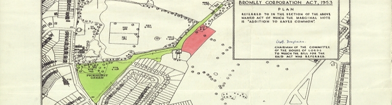
The orders are the Devon County Council (Footpaths Nos. 60 and 61, Luppitt) Definitive Map Modification Order 2017 and the Devon County Council (Footpath No. 62, Luppitt) Definitive Map Modification Order 2017. The orders are available embedded with the start notice here (at the bottom of the Devon list). There are three claimed footpaths:

  • Footpath 60 (referred to in the decision letter as part of order A), from just east of Wick Cross, southeast near the southern boundary of Dumpdon Hill, south (to the east of Crown All Wood), picking up the track to Woodhayes, then south to the road just short of the parish boundary.
  • Footpath 61 (referred to in the decision letter also as part of order A), from Lower Wick Farm, southeast, through the southern end of Crown All Wood, then picking up the track to Woodhayes by joining footpath 60.
  • Footpath 62 (order B) is further north, from Luppitt village, branching off footpath 1, generally a little south of southwest to join the road at the bend a little south of Greenland.
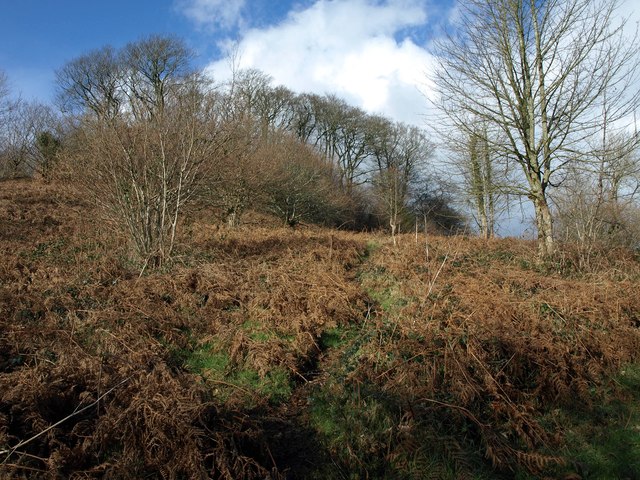
Dumpdon Hill, Devon
View of the hillfort from footpath 60
Photo © Derek Harper cc-by-sa

The paths are all visible on old Ordnance Survey County Series mapping, at least up until the Second World War, and in the case of footpath 62, it was still being shown on the Ordnance Survey National Grid plan as late as the 1960s — see, for the County Series first edition, the links to 60, 61 and 62 (you may need to zoom in or out to view the relevant OS map, and can switch to later editions to compare).

The inspector’s decision letter is available here (scroll down to the relevant decision). The orders were sought on behalf of the Ramblers, and contested by some local landowners: the inspector does not bother to record who objected, only who represented the objectors.

There are a number of factual difficulties with the analysis. Let’s begin with these, first in relation to footpaths 60 and 61.

Paras.15–18, on historical mapping evidence, are not obviously reconcilable with the facts so far as they are disclosed in the decision letter. The inspector refers consistently to ‘one-inch’ maps, but appears to be confused, possibly meaning to refer in certain places to 1:2,500 (i.e., twenty-five inch) maps. For example, at para.15, he states that: ‘By 1889, the OS one-inch, first edition map shows the whole of the route along the line of FP60.’ But the first edition one-inch map (the Old Series) was published at the start of the nineteenth century, and doesn’t show the way — nor would one expect it to show a cross-field footpath. Nor does the Revised New Series one-inch map. Presumably, he means to refer to the Ordnance Survey County Series first edition 1:2,500 map published around 1889 — which does show the way. If a rights of way inspector cannot even get this right, what is he doing determining rights of way cases? (For that matter, this isn’t a very promising basis on which to approach planning casework.) In the next sentence, the inspector says that: ‘The route is again shown on the 1946 one-inch map…’: perhaps this is a reference to the New Popular edition, which certainly shows the route.

But if this was an isolated slip, it is hard to make sense of the first sentence of para.16: ‘FP61 does not appear on any map until the 1946 one-inch map.’ Well — yes it does, it too is shown on the Ordnance Survey County Series first edition 1:2,500 map published around 1889. Now, if the inspector was indeed referring only to the one-inch map, that appears to be correct — although it would be a very odd if the supporters of the order referred only to one-inch maps to document a footpath — few footpaths were shown on nineteenth century Ordnance Survey one-inch maps. But as the previous reference in para.15 to the ‘1889…OS one-inch, first edition map’ appears to be a reference to the 1:2,500 map, it is hard to see that the inspector has a proper grasp of the map scales.

The position in relation to footpath 62 is more straightforward. The inspector simply records, at para.29, ‘There appears to be no dispute between the parties that the claimed route appears on a variety of OS maps dating from 1809 to 1937.’ Well, leaving aside that footpath 62 continues to appear on maps after 1937 (see below), I can find no trace of the way on the Ordnance Survey one-inch Old Series map of 1809 — nor would I expect to (unless the way were in fact an old lane now being used as a footpath)

As it happens, the County Series 1:2,500 maps show all three routes consistently from the County Series first edition published around 1889, but footpaths 60 and 61 have disappeared from the 1964 National Grid plan — whereas footpath 62 remarkably is still shown, some years after the definitive map had been published without it. (As an aside, it is interesting how the publication of public paths on Ordnance Survey one-inch mapping from the 1960s onwards, and only on 1:25,000 maps from the 1970s and 1980s onwards, had a chilling effect on the use of non-definitive rights of way: up until then, many ways, still marked on maps as a physical feature, continued to be used on the assumption that they were rights of way, until the new Ordnance Survey mapping implied that they were not, because they were not shown on the definitive map.)

Accordingly, the inspector’s conclusion at para.18 in relation to footpath 60 and 61 that, ‘The case for the physical existence of the FP61 is at best highly questionable’ is plainly incorrect, particularly when read alongside his statement at para.16 that, ‘Both sections of the Order route [i.e. footpaths 60 and 61] are marked F.P. on the 1948 edition map.’ (The ‘1948 edition map’ appears to be the 1:25,000 map referred to in para.15.) How can the physical existence be in doubt if it is marked on the map as a footpath? One might also conclude that the evidence in relation to footpaths 60 and 61 is therefore not ‘patchy’ (para.18) — only that the evidence does not greatly help with public status, because Ordnance Survey maps purport not to distinguish private and public rights of way. Perhaps the inspector merely means that there is only post-war evidence of the existence of footpath 61 — but that is only if one looks at smaller scale maps

And the conclusion (para.40) that the ‘historical mapping evidence is ambiguous with regard to Order route A [i.e. footpaths 60 and 61] but supports the physical existence of a path along the line of Order route B [i.e. footpath 62] during the first half of the 20th century and possibly before’ must also be wrong. While ‘ambiguous’ might be a reference to public/private status, it is clear from the following words that this is not what the inspector has in mind. But the historical mapping is all one way: the paths are shown consistently over several editions of large scale mapping, being omitted only after (and in the case of footpath 62, long after) the definitive map implied that there was none. And indeed, the statement as regards footpath 62 (‘supports the physical existence of a path…during the first half of the 20th century and possibly before’) is a contradiction of what was said in para.29: ‘…the claimed route appears on a variety of OS maps dating from 1809 to 1937.’ Admittedly, the inspector’s conclusion in para.29 as regards the 1809 map is wrong — but the way was certainly shown on the County Series first edition 1:2,500 map in 1889.

To be fair, we cannot tell from the decision letter exactly what evidence was provided to the inspector by either party (the surveying authority took a neutral stance) — but we can be quite sure that nineteenth century one-inch maps had nothing to offer, because early one-inch maps seldom showed cross-field footpaths.

Moving on, at para.27, the inspector notes a tree in Crown All Wood (through the southern end of which passes footpath 61) which is said to have blocked footpath for 150 years — yet the inspector has observed (para.16) that the footpath is shown on the 1948 map (and as we have seen, it has been marked on maps since the late nineteenth century).

Only one of the ways, footpath 62, appeared on the tithe map (para.29). There is some further weighty evidence cited in relation to footpath 62: quoting the inspector (para.35): ‘The Parish Council minute books show a consistent record of public money being spent to repair/replace footbridges on the Order route up until prior to the preparation of the Definitive Map. As it is most unlikely that the Parish Council would have spent public money on a private route, I consider that during the early part of the twentieth century there was a widespread belief that the Order route was a public right of way.’

None of these ways was admitted to the definitive map and statement originally compiled under Part IV of the National Parks and Access to the Countryside Act 1949 — obviously, else the orders would not have been made. Why not? Well, this was not a case where the ways were simply ignored (for whatever reason). Footpaths 60 and 61 were shown on the Luppitt parish map (prepared by the parish council, as was required under s.28 of the 1949 Act). But they were not shown on the surveying authority’s draft map (save for a section of footpath at Woodhayes Farm). It was proposed to add footpath 60 north from Woodhayes Farm on a review in 1959, but objections meant that nothing came of it. As the inspector states (para.22), ‘the exact reasons why the routes were proposed and then omitted at the various stages is not fully known today.’

Footpath 62 was recorded in the parish survey, and it was noted that it was shown in the map prepared under the Rights of Way Act 1932. But the claim schedule was marked ‘omit’, and the way was not included in the draft map. Again, the inspector notes (para.33) that, ‘It is not known why or who added these comments’.

In relation to all of footpaths 60, 61 and 62, the Ramblers had adduced evidence prepared under the Finance (1909–1910) Act 1910. The 1910 Act caused every property in England and Wales to be identified on maps and to be valued. The primary purpose was to charge a tax (increment levy) on any increase in value when the property was later sold or inherited. Two aspects of the valuation process relate to highways. First, public vehicular roads were usually excluded from adjoining landholdings and shown as ‘white roads’ (i.e. uncoloured) on the maps. Secondly, discounts from the valuation could be requested for land crossed by footpaths or bridleways: whether such a discount was sought was up to the landowner (it didn’t always pay to reduce the valuation, and anyway, landowners then as now might not want to record the existence of rights of way on formal documents). However, none of the records of the 1910 Act survey was available to the public until the 1980s.

The Ramblers’ evidence showed that deductions had been allowed for paths passing through the specific parcels of land crossed by all three claimed footpaths: given that there was no evidence of any other paths across these fields, it strongly suggested that the landowner recognised the public status of the paths at the time of the valuation.

The landowners, as objectors, pointed out that the ways had seen no use in living memory. This was hardly surprising: the ways were cross-field paths, not shown on modern maps, and presumably impassable. It was also stated that the estate crossed by the ways had been in strict settlement between 1824 and 1920, so that there was no-one with capacity to dedicate. However, the inspector does not explore the question in any more detail, such as whether the ways might have been dedicated before 1824.

So much for the facts. What about the analysis? In seeking to modify the definitive map, one must show not only that the claimed rights of way exists, but also that there has been a discovery of evidence: that is, that there is new evidence which, if the claimed way was previously under review, was not considered at that time. Thus, one cannot simply reopen a claim which was considered at an earlier date, on the basis of a fresh look at the same facts previously available. Having satisfied the ‘discovery’ test, the decision maker is then required to review all the evidence, taken together, to decide whether the claimed right of way exists, on the balance of probability.

In this case, there is no doubt that there is new evidence — that from the 1910 Act survey. So the ‘discovery’ test is satisfied, and the inspector can move on. But he does not. At both paras.29 and 30, the inspector is focused on whether evidence (the Ordnance Survey maps and the tithe map) is new: but it should not matter. This is repeated at para.36 in relation to the parish council minutes of work done on the footbridges. The inspector has accepted the discovery of new evidence, and that should be the end of the matter. What is the relevance of whether the other evidence is new or not? It is quite clear that the inspector is discounting anything which was previously available to the 1949 Act process — regardless of whether it was taken into account, and regardless of whether the decision-making process was reliable.

Let’s have a look at the assessment of the tithe evidence. In relation to footpath 62, the inspector notes (para.32) the observations in the parish survey form that, ‘The reasons for its inclusion are given as: “mentioned in P.C. minutes”‘. The comments of the Rural District Council are recorded as: ‘This footpath is shown on the map prepared under the Rights of Way Act 1932 as a public right of way.’ But the inspector also finds the tithe map supportive (para.29). The survey form is evidence that the tithe map was not used in the parish survey, else it would have been recorded in the survey form. Yet the inspector concludes (para.30) that, ‘…this evidence [i.e. the tithe map, along with old Ordnance Survey maps] cannot be considered to be new, as it was likely that is was available at the time when the DMS was being produced.’

The same issue arises with the parish council minutes of work done to footbridges on footpath 62. The inspector states (para.36), that, ‘This inevitably leads me to the conclusion that the minutes are not new evidence and that that (sic) their contents were properly taken into account in reaching the decision to omit the path from the Definitive Map process.’

Yes, the evidence was certainly available, but that does not mean it was used, and there is evidence that some of it was not used. We know that many parish councils relied primarily on parish opinion and memory (‘the evidence of the oldest inhabitants then living’) — not on documentary evidence. Strictly speaking, it should not matter whether the tithe or parish council minutes evidence is new or not — it is sufficient that there is discovery of new evidence from the 1910 Act documentation. But, given the way the inspector approached the determination, it clearly mattered to the inspector.

At para.34, the inspector gives ‘consideration weighing squarely’ against confirming the order to the omission of footpath 62 from the draft map, and the absence of any objection to the omission. But if there had been an objection, and the way were included, then there would be no order. And if the way had been included and an objection to its inclusion had been maintained, there would have been some determination of the matter, perhaps in a hearing before the county council committee, or in due course at quarter sessions. If it is right to place weight on the exclusion, for unknown reasons, of a way from the draft map, then every attempt to add a way to the map now starts from a huge disability — it will be said it cannot be a right of way because the parish council did not volunteer it for the draft map: the parish council knew best.

But parish councils were not a fair and impartial tribunal to judge whether a way was a public way, and should be included on the draft map. For a start, parish councils generally did not have or seek access to the common historical sources available to researchers today. Most rights of way were recorded by parish councils because they were reputed to be public paths, and were believed to have been used by the public for many years — not because there was documentary evidence of their existence. Often acting on poor advice, a parish council may have omitted a way from the parish map where the way was eligible to be recorded on the map, because:

  • The parish council may have overlooked the way (including where the way was mainly in a neighbouring parish).
  • The parish council may have considered the way, but concluded it was not a public right of way on the information then available to it (which may not have included any documentary evidence at all.)
  • The parish council may have concluded that the way was not a candidate to be recorded on the definitive map and statement, because it was a public road, lane or drove and perceived not appropriate to a record of ‘footpaths’.
  • The parish council may have decided not to claim the way as it was little used, intrusive, burdensome to maintain, or otherwise undesirable from the councillors’ or other local perspective, or taking into account other improper considerations.
  • Or the council may have recorded a road or bridleway as a footpath, because there was little awareness of, and little perceived need to protect, higher rights, and minimal recreational equestrian use of ways to remind people of their true status.

Frequently, no record survives of how decisions were made (in the case of footpath 62, only a terse note of a decision — by whom? — to omit the way). And, perhaps the most telling defect in giving weight to such decisions, invariably we know nothing of the balance of evidence for and against the inclusion of a particular way. It is all very well knowing that, somehow, the parish council arrived at a decision to exclude a particular way — but was that a tough call, in which the parish meeting tested the evidence of witnesses and landowners, scrutinised old parish records, heard the reports of those who had walked the way during the parish survey, was split down the middle and the chairman exercised a casting vote to exclude it? Or was there ample evidence that there was no public right of way (perhaps witness evidence no longer available) and the decision to exclude was overwhelming? Or for that matter, was the decision to ‘omit’ taken by the parish chairman in a telephone call with the County Surveyor, without ratification by anyone else? We do not know, and with the increasing elapse of time since the 1949 Act survey, we shall never know.

The inspector treated the original decisions to omit the paths as effectively res judicata — decisions which carry considerable weight, and should not be overturned lightly. In relation to all three ways, the appearance (paras.20 and 32) is that the decisions to exclude the ways was taken or assented to by the parish council (footpath 60 was also reconsidered on what appears to be a review in 1959). The inspector’s reliance on the strength of those decisions to exclude is wrong for three reasons:

  • The parish council did not have all the evidence before it — the 1910 Act evidence was not available, and the implication is that it did not consider the tithe map evidence in respect of footpaths 61 and 62. And if it had had all the evidence before it, we cannot know what the outcome would have been.
  • The parish council took into account irrelevant reasons in reaching a conclusion — this is not only a general observation (see above), but it is a matter of fact recorded in para.27 of another inspector’s decision letter of 14 December 2017 in relation to footpath 21, Combe Raleigh and 59, Luppitt, where the inspector notes that: ‘The minutes of Luppitt parish meeting of 27 March 1956 records…that “Many of the paths were considered to be now not used and were crossed off”. At a further meeting on 24 April 1956 it was recorded the “Further footpaths were discussed, many were found to be of no public use and omitted”.’ In the present case, the inspector records (para.5) that he ‘assessed these Orders on their individual merits, I recognise the importance of consistency in such matters. Accordingly, I have had regard to [the previous] decision insofar as it is relevant to my consideration of these Orders.’ So the inspector was aware of the weakness of the parish decision-making process.
  • The parish council was not intended to be a fair and independent tribunal for the purposes of its functions under the 1949 Act. And it was not one. It was not normally legally advised, and it may have had very little understanding of the law. It did not have to offer anyone an opportunity to be heard (apart, perhaps, from at a parish meeting). It was heavily influenced by the weight of opinion voiced at parish meetings, from those who were prepared to speak up. Those in charge of the process (the chairman of the parish council) were frequently not disinterested, but local landowners.

Accordingly, the decisions of the parish council to exclude the paths should have been afforded little or no weight. They should not have been treated as res judicata, a convincing vindication that the way does not exist. Still less where, as here, there is convincing new evidence — the 1910 Act evidence — which could not have been taken into account at the time.

The inspector does not mention res judicata, although that principle seems to have been on his mind. Instead, constantly the inspector refers to the presumption of regularity. At para.38, the inspector states that he: ‘must assume the County Council carried out their duties with proper diligence and therefore the “presumption of regularity” applies.’ Is there any evidence that the county council took the decision, or was even involved in it, to omit the way from the draft map? Indeed, we do not even know why the parish council ignored footpaths 60 and 61, and decided to omit footpath 62. At para.40, the inspector says that, ‘the Parish Council minutes in respect of Order route B would have been before the County Council when it made its decision to omit the route from the definitive map in the early 1950s.’ How does he know the parish council minutes were before the county council? And is there evidence that it was the county council which took that decision? What is the relevance of the presumption of regularity? Even a kangaroo court might observe its own rules — but that does not mean its verdict ought be afforded any more respect. What is wrong with the inspectors’ decisions is that they afford a degree of respect to the very part of the 1949 Act process which was, and was intended to be, its least reliable and most pragmatic element: the parish survey and submission.

What the inspector has done, particularly in relation to path 62, is to discount any evidence which either was before the local councils in the 1949 Act process, or could have been; concluded that the decision to omit the paths was correctly arrived at (assuming that proper process was sufficient to synthesise a correct decision) and founded in relevant evidence (as opposed to irrelevant evidence, such as the lack of need for the path); and looked for new evidence to the contrary, of such cogency that it could outweigh the decision to omit. This he fails to find in the 1910 Act evidence — which is hardly surprising, because the weight of the evidence to omit is unknowable. It is as if the inspector fears that the parish council had possession of a stopping up order, now lost. But there is no evidence of that. The likelihood is that the parish council, influenced by landowner objections, decided that there was no need for the ways, notwithstanding evidence that they were public rights of way, and decided to omit them. That, no doubt, is why the decision to omit is documented only by the one word itself — ‘omit’ (para.32). That was an unsurprising flaw in the 1949 Act process. But it does not deserve to undermine applications to rectify those flaws today.

The inspector’s decision in this case is insupportable. It is not only muddled, but it espouses an entirely new principle: that the exclusion of a way from the 1949 Act map represents a glorious synthesis of the opinion of the key participants at the time — local people, landowners, farmers, the parish council, the district council and the county council. But in so many cases, it was no more than a matter of oversight, or a shabby transaction conducted without adequate scrutiny.

Worse, this is not the only decision to adopt this principle: look at the determinations for Devon in 2019, and the decisions in respect of (Bridleway No.15, Thelbridge and Bridleway No. 14, Washford Pyne) Definitive Map Modification Order 2012 and the (Footpaths No. 21, Combe Raleigh and No. 59, Luppitt) Definitive Map Modification Order 2016. Both adopt a similar approach. This is the evidence for the Devonian disease of the title to this blog — three decision letters, broadly contemporary in date, all in relation to Devon, all passing over good quality historical evidence in favour of the sanctity of the 1949 Act process. Two of those decisions were taken by an experienced rights of way inspector, and one — the present case — by a less familiar ‘planning’ inspector. Was this coincidence? Or was the planning inspector under the tutelage of the more experienced rights of way inspector, by which the Devonian disease was contracted? Quite why an experienced inspector has fallen victim to the disease in two successive inquiries in the same area, and passed it on to a colleague, is unclear.

The Open Spaces Society has provided assistance with reviewing all three cases. The other two decisions were both considered by user groups at the time — the British Horse Society (BHS) looked at the Thelbridge decision, and the Ramblers at the Combe Raleigh decision. The BHS sought counsel’s opinion, but the prospects for success were insufficiently certain. Happily, the Ramblers has responded by challenging the Secretary of State on the Luppitt decision. Although he initially defended the decision, a judge granted leave for the matter to go to trial, and the Secretary of State then agreed to quash the decision (not before time). The decision has now been quashed (as is recorded on the gov.uk website), and the order will have to be redetermined. The Ramblers will now be able to address the issues raised by the inspector’s quashed determination at a future public inquiry, and we must hope that the outcome makes more sense. And I have prepared a paper for the BHS on ‘the parish role in preparing the definitive map’, which will enable those in support of such orders to show the weaknesses in the 1949 Act process, and why a decision to exclude a way cannot be relied upon as probative. It is too late for the Thelbridge and Combe Raleigh orders (though if further new evidence can be found, new applications can be made for definitive map modification orders), but the orders for the Luppitt ways will be redetermined, one hopes with the Devonian disease banished.

Postscript: see the subsequent blog, Luppitt 2: the Devonian disease — contagion for the next stage in this saga.


What makes an application? Dealing with s.53(5) applications

Rights of Way Posted on Mon, 15 April 2019 07:10

This article was first published in Waymark, Winter 2018–19 (£, vol 31/3), the journal of the Institute of Public Rights of Way and Access Management, and is reproduced here by kind permission of the then editor. It was prepared by me for and on behalf of the Open Spaces Society. The version here incorporates amendments to the original article in the light of subsequent correspondence — I’m grateful to those who have highlighted any shortcomings. The article refers to the current law in England, but while the relevant provisions of the Deregulation Act 2015 do not extend to Wales, I believe the present position broadly to be the same in Wales.

An application for a definitive map modification order to record this way, at Dane Hill, near Palmstead, Kent, was registered within one week, prior to the application being notified. Not all surveying authorities are willing to register prior to notification.

The promise (if that is the right word) of the reforms to rights of way contained in the Deregulation Act 2015 (the 2015 Act: ss.20–26) appears like a mirage — always shimmering on the horizon, but never quite within reach. So the news, announced in autumn 2018 by Defra, that implementation has been put back a further six months, and now cannot be sooner than late 2019 (but don’t bet on that target), means that we must live with existing systems for recording rights of way for at least another year, and perhaps a good deal longer. And as rights of way user bodies begin to shift into a higher gear on promoting and co-ordinating research into historical rights of way, and volunteers (and in the case of the BHS, professional contractors under its Project 2026) raise the rate of application for definitive map modification orders (DMMOs) under s.53(5) of the Wildlife and Countryside Act 1981 (the 1981 Act), the operation of the existing legislation for handling such applications deserves continuing scrutiny. Not just because surveying authorities — at least in some parts of the country — are now receiving considerable numbers of applications for historical routes, but because proposed transitional arrangements under the 2015 Act will rely on the correct processing of applications by the authority to which they are made.

The 2015 Act, taken with Part II of the Countryside and Rights of Way Act 2000, will — if brought into force — extinguish historical (i.e. pre-1949 in origin) footpaths and bridleways if they are not recorded on the definitive map and statement by the ‘cut-off date’ of 31 December 2025. Under draft regulations considered by the stakeholder working group (which commended the 2015 Act reforms), a historical way will be excluded from extinguishment if it is identified in an application for a DMMO — but only if the application has been registered. Registered means the application must be included in a register held by the surveying authority under s.53B of the 1981 Act. Applicants ought to be (or at least, will in future be) keen to ensure that every application founded in historical evidence is duly registered, so that the application way endures past the cut-off date. There remains some uncertainty about what will happen to applications made close to the cut-off date which are not registered in time, but we can probably assume that specific provision will be made.

The procedure for an application for a DMMO is set out, for now, in Sch.14 to the 1981 Act. But practice varies between surveying authorities. Some register an application soon after receipt, while others do nothing until they have received (under para.2(3) of Sch.14) a certificate of service of notices on owners and occupiers of land. A few — perhaps unfamiliar with applications — appear to have no register at all. What does it take to get an application registered?

The starting point is that an application must be made in accordance with para.1 of Sch.14 — that means in the prescribed form (Sch.7 to the Wildlife and Countryside (Definitive Maps and Statements) Regulations 1993), with a map to at least a scale of 1:25,000, and copies of the evidence. There seems little doubt that authorities can waive some non-compliance with those para.1 requirements — Dyson LJ in R (on the application of Winchester College & Anor) v Secretary of State for Environment, Food and Rural Affairs expressly allowed for local authority discretion where the extinguishment of rights for motor vehicles is not in issue (see para.55 of the judgment): anyone who tells you that Winchester is authority for demanding strict compliance in the general context of a DMMO application doesn’t understand the judgment. But if the authority wants to insist on rectifying non-compliance, now is the time to do so — not after registration, and certainly not some years later when an officer finally grapples with the detail of the application.

Under the Public Rights of Way (Register of Applications under section 53(5) of the Wildlife and Countryside Act 1981) (England) Regulations 2005 (the 2005 Regulations), an authority must register an application within 28 days of receipt (r.3(6)(a)). The 2005 Regulations do not define ‘application’. So what is an ‘application’, the receipt of which triggers the 28 day countdown?

It seems that the authority must, prior to registration, look at what it has received simply in order to establish whether it is indeed a para.1 application. For example, if the authority received a letter stating (in so many words) that there was a historic right of way between A and B, and please would the council make a definitive map modification order — the authority would not wish to register that as an application. (An irony of the requirements imposed on an applicant by para.1 of Sch.14 is that such a non-compliant letter might nevertheless alert the authority to evidence of the existence of an unrecorded right of way, and trigger its duty under s.53(2)(b) and (3)(c)(i) of the 1981 Act anyway to make a DMMO. It is only because this general duty is widely ignored that applications are so important.)

That is not to say that the authority must, before registration, determine the application, or even carry out a preliminary assessment (as it will be required to do after the 2015 Act is brought into force). At this stage, it must be enough to exercise common sense — check for the correct form, properly completed, map to sufficient scale, list of evidence, evidence attached (not whether the evidence is sufficient), signed, dated. This is not the time for an investigation, but a cursory check. But if there is anything present (or not present) which, later on, would cause the authority to decide that it cannot even determine the application (as opposed to refusing it), then it should be identified and communicated right away.

if the application looks properly made in accordance with the requirements of the legislation, it can be registered — and if it isn’t, the authority should write back and point out the mistakes.

This might also be a good time for the authority to offer any advice to the applicant about the ownership or occupation of the land affected by the application, if the authority has particular knowledge. Whether an authority can communicate that knowledge to an applicant (who, after all, by virtue of para.2(1) is under a duty to serve notices on the owners and occupiers) without breaching data privacy is an interesting question to which I do not have the answer.

But it is at this stage that some authorities’ practice differs, with an insistence that the authority will take no action on an application until the applicant has proceeded to comply with the requirements of para.2 — the service of notices, and certification of compliance. It may be said by the authority that there is no ‘application’ at all, and that the requirements of the 2005 Regulations do not bite, until the applicant has got past para.2. That insistence may be wrong, for several reasons.

First, there is the plain language of the 1981 Act itself. Para.1 provides that ‘An application shall be made in the prescribed form’, and sets out what must accompany the form. Para.2(1) then requires that, ‘the applicant shall serve a notice stating that the application has been made…’. This makes clear that ‘the application has [already] been made’. What is required of the applicant by para.2 is notice of something that has already happened — the application.

Thus, where the 2005 regulations refer to an ‘application’, they must bear the same meaning as in the parent Act — and that is that an ‘application has been made’ when the requirements of para.1 are satisfied.

Secondly, there is Defra’s Register of definitive map modification order applications — Guidance for English surveying authorities to accompany Statutory Instrument 2005 No 2461 (i.e. to accompany the 2005 Regulations). Inevitably, Defra’s guidance is no longer maintained on gov.uk, meaning it has a zero profile, and leaving one uncertain whether Defra means that it still should be relied upon (in practice, the absence of a profile simply reflects Defra having lost control of its web presence). It is available archived [scroll down to Registers of modifications, applications and declarations.]. The guidance states at footnote 2, that:

‘While, by virtue of paragraph 3(1) of Schedule 14 WCA 1981, the obligation to investigate the matters stated in the application does not arise until a surveying authority has received a certificate under paragraph 2(3) of Schedule 14 WCA 1981, by virtue of regulation 3(6) [of the 2005 Regulations] the obligation to include an entry in the register relates to the date the application is received by an authority. Thus, the obligation to include an entry in the register is independent of the receipt of certification that paragraph 2 of Schedule 14 WCA 1981 has been complied with. Of course, the fact that there is an entry on the register in relation to an application does not affect: (i) the date on which an authority must begin investigating the application, or (ii) the notice requirements set out in paragraph 2 of Schedule 14 WCA 1981.’

The third reason relies on an amendment made by the Deregulation Act 2015 (Sch 7, Pt 1, para.4), to insert new s.53B(4A) into the 1981 Act (this amendment, in common with the 2015 Act reforms generally, has not yet been brought into force). The amendment provides that (following implementation of the 2015 Act), the 2005 regulations can be amended so as to provide that an entry need not be made in the register until after the authority has served notice of the application on owners and occupiers (under the 2015 reforms, the authority takes on from the applicant responsibility for service of initial notices). Such an amendment would be redundant if an application was not complete until notices had been served. It suggests that the 1981 Act (and therefore the 2005 Regulations) contemplate an application being complete after compliance with para.1 — and before compliance with para.2.

The fourth is a matter of practicality. It is unhelpful to wait until the applicant has wasted his or her time, the notified owners’ and occupiers’ time, and the officer’s time, by serving notices and providing a certificate of service (still less by posting notices on site where required under para.2(2)), and then point out, after all of this has been done, that the application was non-compliant — and please could the applicant fix it and start all over again? The applicant surely is entitled to be informed, soon after application, whether the application is considered sufficiently whole to be entered on the register, and to be notified to the owners and occupiers. The applicant can then proceed to para.2 notification. Owners and occupiers need be troubled only when the applicant, and the authority, are confident that the application is duly made.

And for the fifth, we must turn to the 2005 Regulations. The provision, in r.3(6)(a), demands that: ‘An entry in the register [relating to an application] shall be made by the later of: (a) the date falling 28 days from the date such application is received by a surveying authority’ — not the date that the para.2(3) certificate is received by the authority. The regulations demand that the application (referred to as such) is registered within 28 days regardless of whether, and if so, when, it is certified. If the regulations intended to allow 28 days from the date of receipt of the certificate, vice the application, they ought to have said so.

It is not that para.2 notification is dispensable. An applicant may in certain circumstances be content that the application remains on the register potentially indefinitely, and see no need to comply with para.2. But para.3 is clear that the authority is under no obligation to determine an application, and the applicant cannot after one year ask the Secretary of State to direct determination, unless the para.2(3) certificate of service has been received. That is a powerful driver for compliance with para.2, at least for most applicants.

It must be said that some eager applicants — aided and abetted by misleading guidance published by some authorities and others — sabotage the legislative scheme in Sch.14 by making a ‘rolled-up’ application which purports to comply with both para.1 and para.2 — that is, the application is accompanied by the certificate of service, presumably which together were despatched by the applicant at the same time as the notices were served. This cannot be right: an application cannot be made, the notices served, the notices received and the certificate issued, all on the same day (at least, not without some incredibly nifty footwork involving personal delivery at all stages) — even assuming that the applicant does not need to be assured of successful service through recorded delivery or other tracking mechanisms (a point which deserves an article of its own). In R v Isle of Wight County Council ex parte O’Keefe and O’Keefe [(1989) 59 P & CR 283, [1989] JPL 934], one of the grounds of challenge to an order was that the relevant notices had not been served (the judgment wrongly refers to the duty being on the authority to serve notices). Macpherson J said:

‘The point is taken that the date of the relevant notice addressed to Mr. O’Keefe (…11th May 1987) is the same as the date on the paragraph 2(3) certificate (…). Therefore there could not have been service on everybody before the certificate was signed on 11th May 1987.’

Applicants accordingly should be advised to take paras.1 and 2 step by step:

  • apply (para.1)
  • await validation of application as ‘duly made’
  • await registration (s.53B and the 2005 Regulations)
  • following registration, serve notices (para.2(1), and para.2(2) if relevant)
  • certify service of notices after the applicant is confident that the para.2(1) notices have been received (and if relevant, the para.2(2) notices have been erected on site) (para.2(3))

Each of these elements should be taken sequentially.

Some surveying authorities resist registering applications ahead of certification partly because, in consequence, a landowner may be astonished to discover a registered application (of which the landowner has not been notified), still more one which the authority has no duty to determine, yet is destined to remain on the register indefinitely — a blight on the property. Perhaps so — although the authority cannot be held liable for implementing the legislation in accordance with its duty.

But consider the position where a person acquires land following a clean pre-purchase search, only to discover subsequently that the surveying authority was in receipt of a duly made application to record a right of way across that land, and that the application did not appear on the register (and was not notified on the search) because, owing to the para.2(3) certificate being outstanding, the authority had failed to register it within 28 days in accordance with the 2005 Regulations. The authority may well be liable for nonfeasance, because the authority would be in breach of its duty to register, and the failure to register may have serious consequences for the purchaser. The primary duty must be for the authority to register applications — not to concern itself with the consequences of registration where the registration is done lawfully.

In any case, any open-ended sterilisation of land arising from a registered application which has not been certified will, on current expectations, be brought to an end by regulations implementing the 2015 Act. These may well require surveying authorities to carry out a preliminary assessment on all registered applications, whether they have been notified or not. If those arrangements are confirmed, expect to see more applicants resile from para.2 service in the run up to the implementation date. Otherwise, the service of notices by the applicant generally is a pre-requisite to determination. But it is not a pre-requisite to registration, and common sense suggests that authorities should confirm whether applications are duly made within a short time of receipt — and if they are, add them to the s.53B register within the 28 days allowed.


From a Wild Frontier to the Promised Land?

Rights of Way Posted on Wed, 10 April 2019 20:47

I am pleased that John Andrews has agreed to post here his review of a lifetime spent battling to save and maintain public rights of way in Suffolk. John lived in Suffolk for forty-odd years, and as a doughty member of the Ramblers’ Association, did much to revive the network in Suffolk, and pursued applications to add paths to the definitive map long before such applications fully entered onto the radar screens of the user organisations (driven by the Countryside and Rights of Way Act reforms).

John is also the claimant, admirably supported by the Ramblers, in both the original and follow-up actions against the Secretary of State, which eventually showed (as was obvious then and now) that inclosure awards made under the Inclosure (Consolidation) Act 1801 could appoint new public rights of way less than 30 feet wide — for more about that, see my blogs 1, 2, 3 and 4!

By way of introduction, John writes:

‘As the years have drifted by since I moved away from Suffolk nearly 12 years ago, I have had a steadily increasing feeling that some of the episodes through which I and my friends in Suffolk Ramblers lived, notably in the 1970s and 1980s, now seem so remarkable as to make me begin to suspect that they were nothing more than products of my imagination. However, they did all happen and I hope that, in recalling them in this way, I have made it just a little harder for the events of those times to remain unknown or become lost to memory.’

Do read John’s review: it is hard to imagine now just how pioneering it was in the 1970s and 1980s, campaigning for rights of way in a rural, arable county such as Suffolk.

From a Wild Frontier to the Promised Land? — Discovering Suffolk paths


A limitation on TCPA orders?

Rights of Way Posted on Sun, 08 July 2018 11:30

This article was first published in the Spring 2018 issue of Waymark, the journal of the Institute of Public Rights of Way and Access Management, and is reproduced here with kind permission of the editor.

Section 257 of the Town and Country Planning Act 1990 confers broad powers on the local planning authority, by order, to stop up, divert or improve a footpath, bridleway or restricted byway (which I shall refer to indiscriminately as a ‘public path’) where it is necessary to enable development to be carried out in accordance with planning permission.

A widespread view is that paths diverted by s.257 may not be made subject to limitations. This article poses the question — why not?

An A-frame stile at Queensbury Bradford
Can a s.257 order authorise this structure on the diverted path?
Photo © Humphrey Bolton cc-by-sa

A limitation is not defined in statute law, but is generally thought to be a constraint nominally imposed by the landowner on the otherwise lawful public entitlement to use the highway. A stile or gate is the most obvious and commonplace limitation encountered on public paths.

S.257 contains no express provision about imposing limitations in an order made under that section. But if we compare it to the other widely used power to divert public paths, in s.119 of the Highways Act 1980, s.119(4) provides for:

‘A right of way created by a public path diversion order may be either unconditional or…subject to such limitations or conditions as may be specified in the order.’

This variance in drafting is often held to mean that s.257, lacking the express power to impose limitations found in s.119(4), cannot be used to create a new public path subject to limitations (let’s leave aside here the question of conditions, the meaning of which is elusive). But we should make some allowance for the diverse origin of these provisions: s.257 originates in s.94 of the Town and Country Planning Act 1968 (and before that, for highways generally, in s.49 of the Town and Country Planning Act 1947), while s.119 originates in s.42 of the National Parks and Access to the Countryside Act 1949. Thus s.119 was conceived in the 1949 Act which established the definitive map and statement — including s.27(4), which provided for the statement to contain any ‘limitations or conditions affecting the public right of way’. It was hardly surprising that Parliamentary counsel, drafting both clauses in Part IV of the Bill, saw a need for diversion orders expressly to amend the definitive statement in relations to limitations, and put words in s.42 to do just that.

And while the provision for limitations in s.119 has, because of its neighbouring familiarity, found its way into other powers subsequently inserted in the 1980 Act to divert paths — ss.119B (schools) and 119D (SSSIs) but not, oddly, s.119A (railways) — and is seen in the powers to create paths (ss.25 and 26), which also originated in the 1949 Act, it is not found in s.30 (dedication of highway by agreement with parish council). Why not? Because the 1980 Act is a consolidating act (it draws into one place provisions found previously in many acts), and s.30 does not derive from the 1949 Act, but from s.8(1)(g) of the Local Government Act 1894. It was drafted in another era, and no-one saw fit, in 1959 (when highways legislation was first consolidated) or in 1980 (when the legislation was consolidated again), to revise it to bring it into line with other provisions in the host Act. Does this mean that s.30 agreements cannot include limitations? No more nor less than s.257 orders.

Section 30 of the 1980 Act, and s.257 of the 1990 Act, have something in common. They both enable works to be carried out on the new way (whether created under s.30, or diverted under s.257). S.257(2)(b) provides that:

‘(2) An order under [s.257] may…provide—

(b) for authorising or requiring works to be carried out in relation to any [public path] for whose stopping up or diversion, creation or improvement provision is made by the order’

Whereas s.30(2) provides that, where there is a s.30 agreement:

‘(2) [the parish council] may carry out any works (including works of maintenance or improvement) incidental to or consequential on the making of the agreement or contribute towards the expense of carrying out such works, and may agree or combine with the council of any other parish or community to carry out such works or to make such a contribution.’

Subs.(2) above was added to the 1959 Act, to expand on what was originally contained in s.8(1)(g) of the 1894 Act, and remains part of s.30 of the 1980 Act.

What sort of works are contemplated by these provisions? Under s.257, the works can be done on the diverted way, or on an alternative way which is to be improved under subs.(2)(a) (it seems that the works can be done even on the way stopped up, perhaps physically to prevent continuing use). Such works might include:

  • improving the surface;
  • widening the path (if improving an existing way under s.257(2)(a));
  • street furniture (such as benches or litter bins);
  • a bridge;
  • safety apparatus (such as a chicane, or barrier adjacent to a carriageway);
  • a stile or gate;
  • a cattle grid and bypass;
  • a private road crossing with gates.

But some of these works would amount to a limitation on the newly created public right of way — for example, a gate or chicane. Can an order under s.257, or an agreement under s.30, provide for them, notwithstanding the absence of express words about imposing limitations?

Section 257 is a pretty flexible provision: it facilitates development on land crossed by public rights of way (and s.247 does something similar for land crossed by highways generally). It enables stopping up, or diversion, or combined stopping up and creation, or stopping up together with improvement of an existing highway. It enables a replacement way to be of a different status to the one stopped up (although if the replacement way is a carriageway open to mechanically propelled vehicles, it seems there can be no provision for works under subs.(2)(a)). Beyond the initial ‘necessity’ mandate, it imposes no statutory tests on the confirmation of an order other a simple merits assessment. Why should we infer that, despite this flexibility, and despite a power to provide for works, those works cannot limit the right of way in any respect?

There is no obvious reason why s.257 should address limitations: it is enacted in an Act about planning, not highways. Limitations are not mentioned in the 1990 Act (nor in the 1968 Act) in this context. It would be very odd to read ‘works’ as being confined to things which do not amount to limitations, particularly because such an interpretation would greatly limit the scope of the developer to remedy the constraint imposed by the existence of a highway across the development site. If the site is being developed for housing, that may not always be a problem — but what if it’s being developed with an agricultural barn, and stiles or gates are essential to the alternative route — can it really be intended that s.257 is useless for such purposes, and recourse must be had to s.119? What if the diverted way begins in a field, and then crosses a housing estate: must the necessary gate out of the field be authorised under s.147?

Section 30 had different antecedents. But it is now nearly 125 years old. It would be an empty power if a parish council could not agree with a landowner to create a new highway unless it was free from limitations. It would be impossible to create a public path across fields (no stiles or gates allowed).

Apart from s.30 (and s.119A), s.116 of the 1980 Act also lacks a power to impose limitations. S.116 enables a highway to be diverted in the magistrates’ court. Its origins are found in s.16 of the Highways Act 1773, and quite possibly earlier than that. But neither s.116, nor the provisions from which it is derived, have anything to say about limitations or even works. Yet many readers will have encountered court orders diverting public paths which inevitably provided for the negotiation of field boundaries by gates or stiles. Some are still made with such limitations today. Is the presence of these limitations unlawful even now — after all, limitations cannot be legitimised by the passage of time?

Or can we conclude that the express power to impose limitations in the s.119 suite of provisions is an ‘avoidance of doubt’ provision — there to make clear that the power exists (and should be employed where appropriate), but not to be taken so that its absence from other provisions implies that the power is then wanting? After all, the creation of a new public path is a bargain between the local authority acquiring new rights across land on behalf of the public, and the landowner conceding those rights. Why should it be an ‘all or nothing’ arrangement by which the landowner is compelled to retain nothing of benefit (such as the right to maintain a gate)?

Even if the answer is ‘no’ (and that would have a pretty radical impact on the efficacy of s.116 orders), we can still rely, for the purposes of s.257 and s.30, on the power to construct works. Works specified in a s.257 order or s.30 agreement may well not be limitations, and need not be recorded in the definitive statement — but they may be, in which case, they should be. It surely is a bizarre interpretation of s.257 which requires the works contemplated by s.257(2)(b) carefully to be sifted out to decide which do not amount to limitations and so are capable of authorisation, without any clear words to impose such a requirement. If the draughtsperson intended such an outcome, why was the expression ‘works’ not expressly constrained in any way?

But what about the prescribed form of s.257 order? R.2(1) of the Town and Country Planning (Public Path Orders) Regulations 1993 provides that:

‘A public path order shall be in the relevant form set out in Schedule 1…or in a form substantially to the like effect, with such modifications as may be required…’.

Form 1 in Sch.1 allows for the order to recite (in art.2) how the new way will be improved, or (in art.4) how works will be carried out to it, and these improvements or works should be described in the schedule to the form of order. Once one accepts that the order may specify works which amount to a limitation on the public right of way, and those works are recited in the schedule to the order, it remains only to record those works as limitations in the definitive statement via the consequential legal event modification order made under s.53(3)(a) of the Wildlife and Countryside Act 1981, or in a combined order. For example, the order might provide:

‘4. The following works shall be carried out in relation to the highway described in Part 2 of the Schedule: installation of gate to British Standard 5709:2006 at point X on the order plan.’

and Part 2 of the Schedule might read:

‘Description of site of alternative highway

…passing through a gate at point X, grid reference TQ05677650…’

Such drafting is consistent with r.2(1), and the gate is a work contemplated by s.257(2)(b). Why should the gate now not be recorded as a lawful limitation in the legal event modification order?

The express reference to limitations in s.119 of the 1980 Act is helpful, and ensures that provision for limitations is considered in the context of any public path diversion order. But it should not be taken to establish the benchmark for all other provisions enabling the creation of new public paths, which originate in other enactments, from other eras, with other purposes. There need be no limitation on the use of limitations.


DMMO applications: paragraph 1 compliance

Rights of Way Posted on Sun, 27 August 2017 16:50
Roman Road, Sutton next Ripple, Kent: PannageMan applied under para.1 in November 2016 to record this short length of Roman Road as a restricted byway (the paved road turns left here)

A previous blog explored applications under s.53(5) of the Wildlife and Countryside Act 1981 to surveying authorities for a definitive map modification order (DMMO), so as to amend the official definitive map and statement to add a right of way, to modify the details of an existing recorded right of way, or to delete a right of way already shown. It looked at the procedure in para.3(2) of Sch.14 to the 1981 Act for the Secretary of State to direct an authority to determine such an application where it remains undetermined one year after the date on which the application had been certified by the applicant as compliant with para.2. This blog looks at the requirements of a s.53(5) application, and in what circumstances such an application might be rejected for non-compliance.

An application under s.53(5) is to be made in a certain form set out in para.1 of Sch.14. It must be ‘made in the prescribed form’ — that is, prescribed by the Wildlife and Countryside (Definitive Maps and Statements) Regulations 1993 (SI 1993/12), ‘accompanied by—(a) a map drawn to the prescribed scale and showing the way or ways to which the application relates’ (the prescribed scale being 1:25,000: see r.2 applied by r.8(2)), ‘and (b) copies of any documentary evidence (including statements of witnesses) which the applicant wishes to adduce in support of the application.’ R.8(1) provides that an application must be in the form set out in Sch.7 to the Regulations, ‘or in a form substantially to the like effect, with such insertions or omissions as are necessary in any particular case.’

Many such applications are made, often by applicants who have little or no interest or practice in rights of way as such, but are motivated by particular circumstances which befall them — a challenge to a long-used path, or a conviction that a path through their premises was wrongly recorded. Surveying authorities often provide a template of the Sch.7 form to assist applicants (with words to be inserted or crossed-out as the case may be), but even if the form is correctly completed (and it may not be), there is still room for error in getting the map wrong, or providing the right copies of documentary evidence. Indeed, one question to which PannageMan seeks an elusive answer is what amounts to a copy of documentary evidence: if an application relies on the entry in a deposited railway plan and book of reference, is it sufficient to supply a copy of the particular intersection of application path and proposed railway in the plan, and the relevant entry in the book of reference, or must one supply a copy of the relevant pages in both, or of the entire set of plans and book of reference?

But what if, as is likely, an application fails quite to comply with the requirements of para.1, including those prescribed in the 1993 Regulations? Is the application invalid, and to be disregarded, or must it be treated as an effective application anyway?

Some commentators turn for assistance to R (on the application of the Warden and Fellows of Winchester College and Humphrey Feeds Limited) v Hampshire County Council and the Secretary of State for Environment, Food and Rural Affairs, decided in the Court of Appeal. This was a judicial review of the decision of the defendant council to make DMMOs to record two byways open to all traffic across the claimants’ land. The DMMOs had been made in response to two s.53(5) applications. Rights for mechanically propelled vehicles (MPVs) along the ways were potentially extinguished by s.67 of the Natural Environment and Rural Communities Act 2006, but s.67 provided that the rights were excluded from extinguishment if the s.53(5) applications were made before a certain date (they were) and if the applications were: ‘made in accordance with paragraph 1 of Schedule 14’. In fact, the applications were defective, because they listed the documentary evidence supporting the applications, but did not provide copies. The court decided that the applications were not ‘made in accordance with paragraph 1’ for the purposes of s.67, and so they were not valid applications for the purposes of excluding the extinguishment of rights for mechanically propelled vehicles under s.67.

Winchester is sometimes taken to mean that a s.53(5) application must be fully compliant with the requirements of para.1, or it is not a valid application. But that is not what Winchester decided. As Dyson LJ (who gave the only judgment) made very clear in Winchester, ‘It is important not to lose sight of the precise question raised by the first issue [before the court]. It is whether, for the purposes of section 67(3) of the 2006 Act, the Tilbury and Fosberry applications were made in accordance with paragraph 1 of Schedule 14 to the 1981 Act.’ [Emphasis from the judgment, not me]

He went on to repeat the point: ‘I wish to emphasise that I am not saying that, in a case which does not turn on the application of section 67(6), it is not open to authorities in any particular case to decide to waive a failure to comply with paragraph 1(b) of Schedule 14 and proceed to make a determination under paragraph 3; or to treat a non-compliant application as the “trigger” for a decision under section 53(2) to make such modifications to the DMS as appear requisite in consequence of any of the events specified in subsection (3).’

When the Supreme Court reviewed the decision in Winchester, in R (on the application of Trail Riders Fellowship and another) v Dorset County Council, Lord Carnwath started, ‘from the general principle that procedural requirements such as those in the 1981 Act should be interpreted flexibly and in a non-technical way. …Such a flexible approach is particularly appropriate in the context of an application to modify the definitive map. …under section 53 of the 1981 Act the primary duty to keep the definitive map up to date and in proper form rests with the authority, as does the duty (under section 53(3)(c)) to investigate new information which comes to their attention about rights omitted from the map. An application under section 53(5), which may be made by a lay person with no professional help, does no more than provide a trigger for the authority to investigate the new information (along with other information already before them) and to make such modification “as appears to [them] to be requisite. …”‘

The judgments in both Winchester and TRF make clear that the judicial interpretation of the requirements of the saving for MPV rights in s.67 of the 2006 Act should not be extended to decide whether an application under s.53(5) should be treated as validly made or otherwise questioned: in that respect, s.67 has no relevance to most s.53(5) applications. In his judgment in TRF, Lord Carnwath refers to the speech of Lord Steyn in R v Soneji (para 23) as summarising the modern judicial approach to deciding whether a decision is invalidated where the decision maker fails to abide by some legislative procedural requirement imposed on it, in which Lord Steyn said that the emphasis is: “on the consequences of non-compliance, …posing the question whether Parliament can fairly be taken to have intended total invalidity.” That is the approach which, in theory, a court could apply if deciding whether a defective s.53(5) application is valid.

But for two reasons, that analysis will seldom if ever be called for. First, because a surveying authority, on receiving such an application, must decide whether the application is duly made (i.e. whether it is what it purports to be — a validly made s.53(5) application) and if it is, include it on its register of such applications held under s.53B of the 1981 Act. Under the Public Rights of Way (Register of Applications under section 53(5) of the Wildlife and Countryside Act 1981) (England) Regulations 2005 (SI 2005/2461, as amended), an application must be registered within 28 days of the date the application is received by the authority (r.3(6)(a)). If the authority decides that the application is invalid, and it is not minded to waive the invalidity or to seek to resolve it, then the application is not an ‘application’ under s.53(5) and it need not be registered. It follows that, if the authority registers the application, it must be satisfied that the application is validly made, or by implication, it has decided to waive any outstanding non-compliance.

One could enter into a debate as to the extent of the surveying authority’s powers to waive non-compliance. After all, para.1 does impose certain requirements on an application. Such a debate would have to consider the principles enunciated in Soneji to decide whether Parliament intended non-compliance with those requirements to promote total invalidity (noting again the expectation of Lord Carnwath in TRF that such an application, ‘may be made by a lay person with no professional help’).

But the debate would be sterile, and that leads us to the second reason why. The effect of an application is to alert the authority to events which call for the modification of the definitive map and statement. But the application is no more than a signal to the surveying authority that it has a duty under s.53(2) to ‘keep the map and statement under continuous review and as soon as reasonably practicable after the occurrence, on or after that date, of any of those events, by order make such modifications to the map and statement as appear to them to be requisite in consequence of the occurrence of that event’.

When the Wildlife and Countryside Bill was introduced to Parliament in 1980, it did not contain provision for applications to be made to the surveying authority for the purposes of triggering a DMMO. This provision was introduced in the House of Lords by Lord Bellwin on behalf of the Government, responding to criticism of the omission. And so the provision for applications was bolted on to s.53 and Sch.14, without quite resolving the tension created by those amendments — why does a member of the public need to make a formal application for a DMMO if the authority itself has a duty to act ‘as soon as reasonably practicable after the occurrence…of…events’? An authority cannot be omniscient, but surely, at least in theory, it would have been sufficient for a member of the public to write to the authority pointing out that certain events had taken place, and wouldn’t the authority (pursuant to its statutory duty) like to investigate and, if it thought fit, make a DMMO? Conversely, why impose regulatory requirements on an applicant, if a simple letter ought to be all that is necessary? The Minister, speaking to his amendment, said, ‘that to protect authorities from frivolous applications a formal procedure such as is provided for in the amendment was essential. That a person takes the time and trouble to produce the necessary evidence and plan is a clear indication that the claim is not frivolous, and that his application merits serious consideration.’ But an authority receiving a frivolous letter need have done nothing at all.

Even if the application is defective in some way, the surveying authority will be on notice that events have occurred which trigger its duty to make a DMMO. It therefore does not greatly matter that the application may be defective in some way: it has achieved its purpose, which is to nudge the authority into performing its standing duty. Of course, if the application is so defective that the authority does not have the slightest idea why the applicant thinks that a DMMO is called for (in which case, it ought to have been rejected at the time of the application as not duly made), or having weighed the evidence, the authority concludes that, on the balance of probabilities, there is no case to make a DMMO, it need do nothing (apart from refusing the application).

But what if, at this stage, the application is identified as defective in, for example, lacking copies of certain documents listed in the application, or the scale of the attached map is less than the prescribed 1:25,000? Neither of these flaws impairs the communication to the surveying authority of the nature of the events referred to in it. Therefore, what basis can there be for the authority to reject the application as defective and to refuse to make a DMMO if the evidence otherwise stacks up?

If a surveying authority does wish to rely on the legislative requirements for an application, the proper time to impose such requirements is within 28 days of the date of application, before the application is registered in the s.53B register, by refusing the application as not duly made. In PannageMan’s opinion, once the application is registered, the authority must, in due course, determine the application as if it were validly made, on the strength of the evidence submitted.


« PreviousNext »